Location: 32.90409N 21.96733E
Let me put things straight: I have never been to Apollonia (I did not go further than Leptis Magna) but I met some of the most knowledgeable persons (Nic Flemming, André Laronde (†), Jean-Pierre Misson, Claude Sintès) who convinced me that Apollonia hosts the most important ancient port remains, preserved mainly because they are now under water. I would not feel entitled to write anything on this port, were it not that Jean-Pierre Misson showed me some underwater pictures made in the sixties and in 2012 that are not yet published elsewhere. Moreover, Nic Flemming accepted to comment on the relative Sea Level Rise (SLR) which is a complex problem in Apollonia.
They did me great honour to accept publication on this web site.
I therefore rely heavily on quotations from several authors.
Apollonia is a unique ancient port
Knucklebones on a lead anchor stock
In Nic Flemming’s words (personal communication, 9/2/2014):
“I have seen hundreds of other ports. […] Apollonia is unique.
The unique features of Apollonia are:
• Relatively early date, 6-7th century BC, and later during the epoch of trireme warfare. No other complete harbour of this date.
• Completeness of port area, shore side, and dock structures. It is a complete ‘deck of cards’ so to speak, with nothing missing. A complete range of different structures and ancient technological functions, some still unexplained.
• Completeness (although collapsing) of the original sea defences, sea walls, cut wave traps, rubble breakwaters, as a complete system.
• Multiple layers preserved in stratigraphic context of at least 3 generations of structures on the dockside, all submerged, in the period 600 BC to Hellenistic/Roman.
• Numerous structures and rock-cuttings which are still unexplained, like the nine ‘quays’.
• Excellent clear water, easy place to film or work, and layers of sand accumulated which will preserve pottery and other artefacts. Hardly any excavation in the underwater city, so a great deal still to be learned.
• Evidence that micro-features such as lead dowels, carvings, statues, pottery and other small items neglected in previous surveys still survive.”
Quoting Kalliopi Baika (2013) on the History of Apollonia:
“The ancient harbour of Apollonia in Cyrenaica was the epineion (out-port) of Cyrene, which lay 18 km inland. It is in a broad open bay, delimited to the east by Cape Naustathmos (Ras el-Hilal) 20 km away, and to the west by Phycus ([near] Ras Aamer).
The natural harbour must have been in use since the foundation of Cyrene in 631 BC as a Greek colony from Thera. Apollonia is recorded as established in ca 600 BC as the ‘harbour of Cyrene’. Cyrenaica became a dependency of the Ptolemaic kingdom under Ptolemy I Soter in 322-321 BC. The cities of Cyrenaica became independent in 97 BC, after the kingdom passed to Rome. It received the name Apollonia. Mark Antony restored Cyrenaica to the Ptolemaic empire, and after the Battle of Actium it was combined with Crete, under Roman rule. Apollonia was an excellent naval base in a very strategic position in Cyrenaica, and Roman fleets were maintained there. The city was renamed Sozousa, when it became the capital of Upper Libya, a province created by Diocletian.”
Quoting Kalliopi Baika (2013) on the Port of Apollonia:
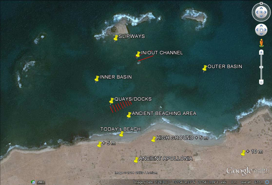
“Apollonia was served by two harbour basins accessible in all weathers, the prevailing winds on this coast being from the north-west. The basins were formed on the rocky coastline by a projection on the west, and by a projection (which is now two islands, Îlot Hammàm and the smaller Îlot Sharkéa on the east) which protects them from the north.
The western harbour, that was an inner harbour communicating with the eastern one via a channel, probably originally had an entrance on its north. The eastern harbour was open on its eastern side, between Îlot Sharkéa and the coast, with a lighthouse located on the southern end of this island. The channel connecting the two basins was later walled and protected on each side by two fortification towers that were part of the city fortification system. The western harbour, which was partly included in the city walls, contained the main complex of slipways. In general, the harbour underwent several reconstructions from the Classical period onwards. The channel between the harbours was deliberately filled in late antiquity so that the eastern harbour became the only harbour.
The western harbour had at least five rock-cut complexes on its perimeter. However, only one group is now identified with certainty as slipways. This is located on the Îlot Hammàm in the north-east corner of the western basin.
The small complex in the eastern harbour on Îlot Sharkéa, which was thought to be shipsheds, is now, after underwater exploration, identified as a quarry. The other harbour remains and rock-cut structures on the west and south edges of the western harbour and now submerged could have been ship-building areas, quays or warehouses.”
According to the latest research, the Glacial Hydro Isostatic Sea Level Rise in this region was only 0.30 to 0.50 m during the past two millennia (Morhange, 2014). However, the relative SLR was much different in many places as it includes tectonic movements: in Apollonia, mainly subsidence.
Quoting Kalliopi Baika (2013) on the Relative Sea Level Change at Apollonia:
“[…]. The French team that carried out supplementary investigations at the entrance towers to the western harbour estimated a difference in sea level of 3.50 m, with a small variation for the small tides. This evidence was based on indications of lithophaga on the sides of the fortification towers facing the channel. This level was tested on all features submerged in the harbour and gave satisfactory results for 90 per cent of them. In addition, in the channel the surfaces of the walls below the ashlar superstructure are rock-cut, suggesting that they were once above sea level. The artificial blocking of the channel, which terminates at the same level as the lithophaga lines, offers additional support for the suggestion of a difference of 3.70-3.80 m since the beginning of the Christian period.”
Quoting Nic Flemming on the Relative Sea Level Change at Apollonia (personal communication, 15/11/2014):
“Knowledge of the numerous possible causes of change of local relative sea has increased greatly since the early days of research at Apollonia in the 1950’s to 80’s. Thus early observations in the field are generally correct, but the explanations in published articles are limited by the contemporary knowledge.
Factors which are now known to have influenced the local sea level are:
• Glacial Hydro Isostatic Adjustment (GIA), that is the response of the sea level and the earth’s crust to the melting of the ice caps at the end of the last glaciation. The most accurate estimations of this cause of relative sea level change on the Tunisian-Libyan coast are by Anzidei et al. (2011) and Lambeck & Purcell (2005).
• For tectonic processes see Ambraseys (1984, 1994).
• For an up-to-date analysis of how all the various causes interact, see Tsimplis et al (2011).
Estimation of the total net change of relative sea level at different parts of the city of Apollonia produce different results, and there is no reason to doubt these values. In order of depth:
• French MAF results: the Lithodomos borings are at -3.0 m-3.8 m in the Christian era.
• Piscina, Fish tank, Flemming (1971): the walk way is at -2.5 m, therefore the sea level was lower than this in the Roman Empire period, probably around – 2.8 m. The floor of the slipway on thick deposits of rubble is at -3.0 m, and the solid floor is deeper than this. (The fish tank is cut into solid rock, as were many piscine all over the Roman world, so they had no problem in cutting rock below the sea level).
• West island slipways (early period around 600-500 BC): the bottom of slips is at -2.8 m.
• Grid building: the depth on the harbour end of the grid, not on the masonry, is at -2.8 m.
• Grotto Reef tunnel: the ceiling of tunnel is just awash, so the floor of the tunnel is a bit shallower than – 2.0 m, and the sea level change must have been more than 2.0 m.
• ‘Quays’: the depth in the neighbourhood of the seaward end of the quays is 2.4 m (with some, unknown sand thickness on the seabed); and 2.2- 2.3 m depth at landward end of quays.
Further discussion of the sea level evidence yields:
• If we take the 3.0 m or more from the French data, then the slipways on the west island are completely high and dry. They would be useless. Since there are small walls built on top of the slipways, and other walls built on the sea floor in the harbour basin below the foot of the slipways, this is consistent with a change of level between 500 BC and the time of the Roman Empire.
• The walkway of the Piscina would be dry by about 50 cm with a sea level change of 3.0 m, which seems a bit much, but not impossible. (A sea level of -3.5 m would make the piscine almost dry!) So, maybe the uplift continued into the Christian era.
• The evidence from these two dates, about 500 BC, and the Empire/Christian period indicate that the city of Apollonia was uplifted by about 50 cm between these two dates, possibly more. This must have been due to earthquake activity (tectonic) since there is no evidence at other archaeological sites for a GIA drop of sea level during this period.
• During the last 2000 years the city has subsided by a total of about 3.0 m, and this relative change of level is made up of about 0.30-0.50 m of rising GIA sea level, and 2.5-2.7 m tectonic subsidence.
• The reversal of tectonic direction is quite common. Close to a subduction or normal fault the ground is dragged one way in a “stick” mode, and then an earthquake allows the fault to “slip”, and the ground moves the other way.
• If these figures are correct, the relative sea level was about 2.5 m lower than at present in the early years/centuries of the city after its foundation. The bottom of the slipways was at least 30 cm underwater, and the sea lapped between the ‘quays’.
• In the following centuries BC the city was uplifted about 50 cm, and the slipways and the ‘quays’ became high and dry. The diameter of the inner harbour contracted, and a secondary group of structures was built on a smaller diameter, varying from 25-50 m in from the earlier circumference or water-front.
• Finally, during the late Roman Empire, or later (perhaps in a famous earthquake), the city was submerged by about 3.0-3.5 m.
Concluding: the dates and events listed above are rough estimates, but it is absolutely evident that the buildings are adjusted to two different relative sea levels at different dates. After the uplift phase, the inner harbour basin contracted in radius by about 25-50 m, and some of the earlier waterfront structures became unusable. The outer harbour would then have been much more important.”
In any case,
the oldest structures which are now 2 m under water
were initially around 0.5 m above water!
Maps & pictures
NB: you can “save” the pictures as HD JPEG images.


The first map was drawn by Nic Flemming on the basis of original drawings by the architect Nick Wood, a member of the diving team led by Nic Flemming, back in the late fifties. It can be found in the Geographical Magazine for 1959 and 1960. It was redrawn for publication in the book “Cities in the Sea” 1971 and we provide a clean HD copy here. It is still considered as an accurate reference.


Nine Quays
These ‘quays’ are located in square E9 of Flemming’s map.
I choose to write ‘quays’ with inverted commas because the initial purpose of these structures is not agreed by all parties at this time. To put it in a few words, some believe these structures are quays for loading/unloading small oared battle ships, some believe they are warehouses.
Let’s try to present the available information here.
Quoting Nic Flemming (1971):
“The ‘quays’ are not closely similar to any structure in other harbours, either ancient or modern, but can only have been used for the berthing of slender ships, either civil or military. […] the spacing of the ‘quays’ is only 3.5 m. Whether this is the maximum beam of the largest vessel, or whether only smaller vessels were berthed at the ‘quays’, is not certain. The docks between the ‘quays’ are 25 m long, and if the ships were this length they would have had a length-to-beam ratio of 7:1, which is high for a cargo boat, but very likely for a fast boat built more to be rowed than to carry a large sail area. From the rough rule that a stable rowing boat draws one third of its beam, these boats would have drawn about 1 m.
The top courses of stone on the ‘quays’ are complete in several cases, with the upper surface only 2 m wide, surprisingly narrow. It would have been impracticable to handle large cargoes in such a small area, and in any case, the heavy cargo ships of the second century BC and later had a beam of 10 m, though they were usually only 30 m long. Thus, if the ‘quays’ are of late date, they can only have been used for harbour lighters and local coastal boats and fishing boats, but if they were of early construction they may have been used for oar-powered military and light cargo vessels. Possibly both suggestions are partly correct, and as time went by, the docks which had once been suitable for the mightiest ships afloat were relegated to the status of a fish market much as the Vieux Port of Marseille is now restricted to fisherman and pleasure boats, while ocean-going cargo ships dock in the modern harbour outside.”
Quoting Baika (2013):
“Flemming investigated nine rectangular structures spaced 3.5 m apart and 2 m wide, identified as ‘quays’. The docks between the ‘quays’ were 25 m long. The ‘quays’ are constructed of ashlar masonry and the top courses are complete in several cases, with the upper surface 2 m below the water. If the identification is correct, they are too narrow to accommodate big commercial ships of any period. According to Flemming, because of their ‘exceptional breadth and solidity, they may have been used as ‘quays’ for small merchant vessels’. These installations were surveyed recently by the French mission, which concluded that they are warehouses, and excluded the possibility that they could be used as docks.”
But if warehouses existed at this place, where are the remains of their roofs (tiles) and of their side walls?
We should note also that according to William Murray (personal communication 10/4/2014):

“quays that are exposed to waves tend to use headers rather than stretchers for the walls exposed to sea action. A long rectangular structure with nothing but headers in the foundation courses would seem to indicate you had a quay instead of a warehouse. […] Your structures seem to have been built in quieter water and thus could have used stretchers.”
The pictures below show some details of the ‘quays’ which are numbered from 1 to 10 starting on the west side. Hence, ‘quays’ 2 to 9 are free standing, while ‘quay’ 1 and ‘quay’ 10 are leaning against land. It is noteworthy that no back wall was found, i.e. the docks between the ‘quays’ end on the beach.


Interpretation by JP Misson
“In Libya, at the time, there were practically no roads inland: the communications were mainly by sea with the major settlements located along the coast. The Libyan coast is rather unprotected: practically no island where to shelter and several stretches of rocky shore where the beaching of a fragile galley is impossible. The oared vessels that were used for the task had to be slim and light to be fast. This was the only way to cover the non-beachable stretches of coast on a day’s duration. It was extremely rare for galleys to navigate after sunset. The galleys were undecked and had a very small draught when empty of their crew. This is what allowed their crews to beach them when needed and where possible.
Because of the lack of roads and because most of the settlements were along the coast, there were surely tens of swift galleys in the harbour of Apollonia (port of the capital Cyrene) ready for dispatching, patrol , escort and such tasks that required rapid deployment for action. In the inner harbour of Apollonia, the simultaneous beaching or launching of several galleys (especially in windy conditions) would not have been easy. The ‘quays’ may have been built for the dockers in charge of hauling the galleys in and out of the water to stand on a hard surface (not in sand) and for crews to embark and disembark in an orderly way. If the ‘quays’ were only needed for the crews to walk on firm ground the ‘quays’ could have been just awash (flush with sea level). If the ships were galleys with practically no cargo except crew, food and water; all easy loading and unloading: no need for a particularly ‘dry’ quay. In any case (prior to the subsidence) the inner harbour must have been a calm water area, much better protected from the open sea than today. The longitudinal axis of all the ‘quays’ is pointing to the centre of the basin of the inner harbour. This allowed the galleys to safely navigate after the launch or when returning to shore.
The ‘quays’ were used as mere ‘walkways’ to enable the people in charge of manoeuvring the galleys to work under dry conditions and for the crew to board or disembark at ease. Executing the launching or beaching operations with people breast-deep in the water would have required a lot more people if not been altogether impossible when several crafts had to be handled simultaneously. The galleys were moved from/into the water to/from the dry land behind. This was the practice in those times for the small and light galleys. Galleys of this size (20-30 m) could be beached by their only crew, during a voyage (where beach slope made it possible) to rest and resupply. With the ‘quays’ in Apollonia these operations were made easier and faster. Assuming that there were many more galleys on the beach behind the docks, the simultaneous launching or beaching of 9 galleys at a time must have been possible at Apollonia. The galleys were probably kept in-between the ‘quays’ for a limited amount of time: beaching or launching operations with corresponding unloading or loading. They were probably never ‘berthed’ there. Without a back wall, the galleys could be hauled on the beach, to be parked somewhere on the terrain south of the ‘quays’. The ‘quays’ could therefore be called ‘hauling quays’.
The docks in-between the ‘quays’ must have therefore been a good 70 to 80 cm deep.
Galleys 20-30m in length would surely have been easily floated and handled in these docks as their draught was very limited, surely much less than one meter.
Moreover, it would not have mattered had the keel of the galleys touched the seabed in the docks even halfway through their length: there would have been sufficient ‘quay’ length on each side to conduct any operation such as hauling, loading and unloading of the vessels. With a depth of as little as 50 cm at shore end, the docks would have been useable.
As for the top layer on the perimeter of the ‘quays’, seemingly above the level of the heavy slabs at the root of each quay: it could well be a raising of the structures after it appeared that the bedrock on which they were standing had started to subside. The space between the additional layer of blocks might have been simply backfilled on top of the initial slabs, and this backfill vanished with later wave action.
Concluding:
• The ‘quays’ were high enough above the bedrock and seabed to create docks in between two adjacent ‘quays’, which were deep enough to float a 20-30 m galley, as the draught of a galley of that length would have been under 80 cm.
• The docks (on average 25 m long and 3.5 m wide) correspond to the 7:1 length/width ratio of a longship.
• The parallel ‘quays’ are oriented towards the centre of the inner harbour where water is calm and deep, enabling an easy approach of the docks.
• The comb-like configuration of the ‘quays’ and docks allowed for the simultaneous launching or beaching of 9 galleys at a time.
• The docks show no back wall making it therefore possible to haul the galleys onto the only sandy shore in the harbour, behind the ‘quays’; although this area is now submerged, it was above sea level in the past.”

This interpretation by Jean-Pierre Misson makes good sense from a pragmatic point of view, but it is hypothetical and would obviously need to be confirmed by more field investigations, as …
Such an arrangement is unheard of in any other ancient port.
… or do we have a similar construction at Punta Sottile near Trieste (Auriemma (2008), p 138) ??
For further information on beaching ancient ships, see Greg Votruba, 2017 « Did Vessels Beach in the Ancient Mediterranean? An assessment of the textual and visual evidence », The Mariner’s Mirror, Vol 103:1, (p 7-29).
Knucklebones on a lead anchor stock

Let’s quote Harry R. Neilson’s abstract of a paper about “Aphrodite (Venus) Euploia on Greek and Roman lead anchor stocks” (2009):
“To date, over one thousand Greek and Roman lead anchor stocks have come to light from the depths of the Mediterranean Sea. Of these, over one hundred are decorated with reliefs. The majority of these decorations comprise symbols relating to Aphrodite (Venus) Euploia. The presence of these symbols demonstrates a close connection with the sea-going manifestation of the goddess whom ancient mariners venerated as a protectress of navigation. An anchor stock recently discovered off western Sicily displays the epithet, Eiinkotu. Four stocks display dolphins and sea shells, well-known attributes relating to Aphrodite’s birth from the sea. Most significantly, over seventy stocks display images of astralogoi (knucklebones) which relate to the high scoring “Venus throw” in the game of chance popular in antiquity.
Through an analysis of the inscription, the attributes, and the astralogoi, this paper illustrates that, in addition to her general association with ships and ports, mariners specifically relied upon Aphrodite Euploia while anchoring. The large number of anchor stocks with astralogoi reveals the superstitious nature of sailors who equated the precarious manoeuvre of dropping and setting the anchor with a “dice throw,” betting that Aphrodite Euploia would guide the anchor to security and hold the ship fast.
Furthermore, that Greek and Roman ships carried on board as many as eleven anchors is a testament to how ancient mariners attempted to beat the odds while anchoring.”
The anchor stock below was retrieved in 1967 by JP Misson and is now on display in the Museum of Marsa Susa (ancient Apollonia).


References
AMBRASEYS, N.N., 1984, “Material for the investigation of the seismicity of Tripolitania (Libya)”, Boll. Geof. Teor., Appl., 26, (p 143-153).
AMBRASEYS, N.N., 1994, “Material for the investigation of the seismicity of Libya”, Libyan Studies, 25, (p 7-22).
ANZIDEI, M., ANTONIOLI, F., LAMBECK, K., BENINI, A., SOUSSI. M., & LAKHDAR, R., 2011, “New insights on the relative sea level change during Holocene along the coasts of Tunisia and western Libya from archaeological and geomorphological markers”, Quaternary International. V.232, (p 5-12).
BAIKA, K., 2013, “Apollonia” in “Shipsheds of the Ancient Mediterranean”, Cambridge University Press, eds. D. Blackman and B. Rankov, (p 294-306).
FLEMMING, N.C., 1959, “Underwater adventure in Apollonia”, Geographical Magazine, v. 31, (p 497-508).
FLEMMING, N.C., 1960, “Apollonia revisited”, Geographical Magazine, v. 32. (p 522-530).
FLEMMING, N.C., 1964, “Underwater survey of Apollonia; preliminary report”, in Taylor, J. du Plat (ed). Marine Archaeology. Hutchinsons, London, (p 168-178).
FLEMMING, N., 1971, “Cities in the Sea”, Doubleday & co, New York, (222 p).
FLEMMING, N., 2021, “Apollonia on My Mind, The Memoir of a Paraplegic Ocean Scientist”, Honor Frost Foundation, Sidestone Press, (550 p).
See also his film on the 1958-59 expedition to Apollonia.
LAMBECK, K. & PURCELL, A., 2005, “Sea-level change in the Mediterranean Sea since the LGM: model predictions for tectonically stable areas”, Quaternary Science Review, 24, (p 1969-1988).
LARONDE, A., 1996, “Apollonia de Cyrénaïque : Archéologie et Histoire”, in Journal des savants, Janvier-Juin 1996, (p 3-49).
LARONDE, A., & QUEYREL, F., 2001, “Un nouveau portrait de Ptolémée III à Apollonia de Cyrénaïque”, in Comptes Rendus de l’Académie des Inscriptions et Belles-Lettres, 145e année, N° 2, 2001, (p 737-782).
MORHANGE, C., 2014, “Ports antiques et variations relatives du niveau marin”, Géochronique N°130, (p 21-24).
QUEYREL F., 1987, “Le motif des quatre osselets figuré sur des jas d’ancre antiques”, Archeonautica, N°7, 1987, (p 207-212).
QUEYREL F., 1997, “Le motif des quatre osselets sur un jas d’ancre du Musée d’Apollonia de Cyrénaïque”, Libya Antica, N°3, 1997, (p 113-117).
SINTÈS, C., 2010, “Les neosoikoi d’Apollonia de Cyrénaïque”, in “Ricoveri per navi militari nei porti del Mediterraneo antico e medieval”, Atti del Laboratorio di Ricerca: Ravello 4-5 Nov. 2005, eds. D. J.
TSIMPLIS, M., SPADA, G., MARCOS, M., AND FLEMMING, N.C., 2011, “Multi-decadal sea level trends and land movements in the Mediterranean Sea with estimates of factors perturbing tide gauge data and cumulative uncertainties”, Global and Planetary Change, doi: 10.1016/j.gloplacha, 76, (p 63-76).