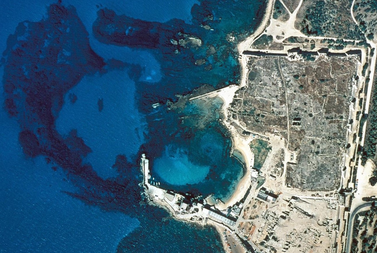
Location: 32.503N 34.890E
The port of Sebastos (the Greek name for Augustus), in the town of Caesarea Maritima, is one of the largest ancient port ruins still visible today. It was built by King Herod between 22 and 10 BC, more than half a century before Rome’s Portus, but later than Agrippa’s naval base of Portus Iulius, near Pozzuoli, in 37 BC. It features the most advanced Roman building techniques ever found by archaeology for coastal structures.
(https://web.uvic.ca/~jpoleson/ROMACONS/Caesarea2005.htm)
Excavations have been conducted on land and under water for several decades at the end of the 20th c. and much has been said on this famous ancient port. Too much perhaps, and it may be useful here to list a few synthetic publications:
- Raban, 1995, providing a synthetic description of the port structures,
- Galili, 2017, providing a synthetic description of the port structures,
- Raban, 2009, providing a complete description of the port structures,
- Raban, 1996, on the inner harbour,
- Oleson et al., 2014, Romacons Project on Roman concrete blocks,
- Galili et al., 2021, on subsidence of the port structures.
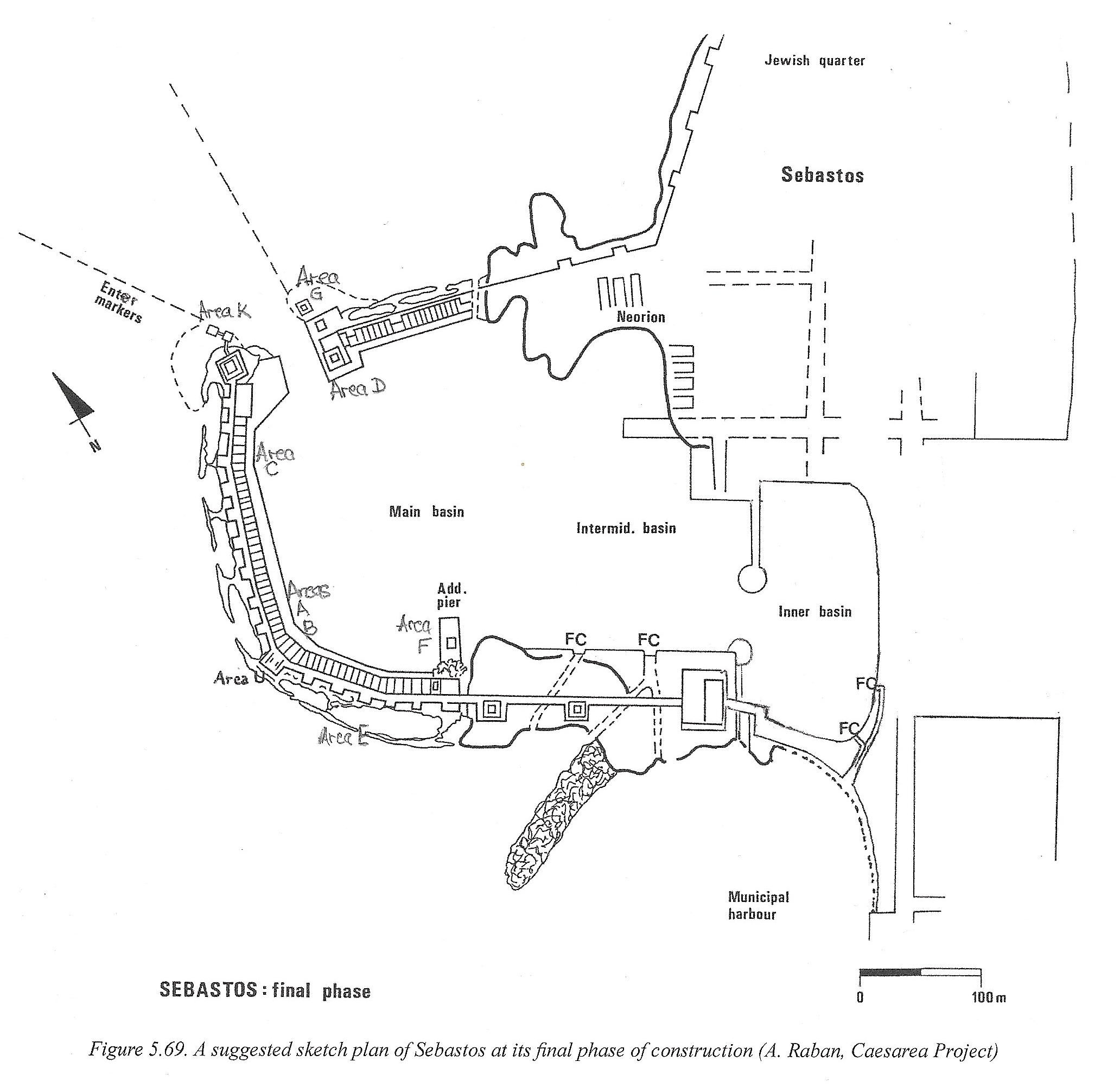
Three harbour areas are usually distinguished:
- Inner harbour, eastern basin, now inland, probable location of the pre-Herodian Stratonos Pyrgos limen kleistos closable harbour.
- Middle harbour, central basin, intermediate basin, built by Herod, with possible shipsheds (“Neorion”) and flushing canals (“FC”), also used by crusaders, and still partly used today by small boats sheltering north of the southern breakwater.
- Outer harbour, western basin, main basin, built by Herod, now submerged, with a 30-50 m wide (closable?) entrance and a probable lighthouse (Drusion).
For the sake of simplicity, let’s assume that the eustatic sea level change was no more than 0.5 m since Roman times (Yasur-Landau, 2021).
We shall not go into a detailed description of the harbours here, as this can be found in the references mentioned above. We would like to select a few aspects that need further explanation and present a few sketches of the breakwater structure.
Prokumia (outer breakwater)
The cross section below is adapted from Raban (2009, p 96) in order to include some measures which are obviously quite approximate. The outer breakwater “BW” was excavated in area E on the southern breakwater and the inner quay was excavated in area C at the northern part of the western breakwater (see harbour layout above). This cross-section is therefore a hypothetical reconstruction of the whole western and southern breakwater structure.
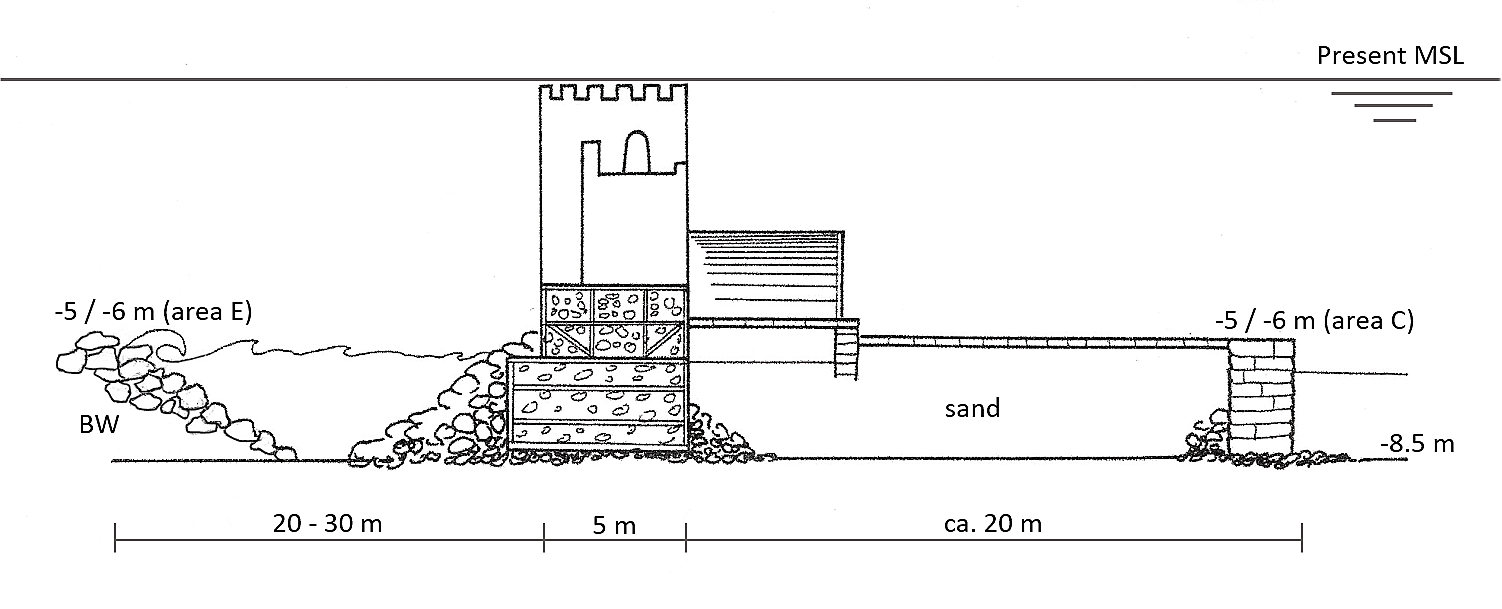
All vertical levels are related to the present Mean Sea Level (MSL). It is usually said that subsidence of the whole outer harbour amounts to 5-6 m since Roman times.
The ancient seabed was found in several places in the outer harbour at ca. -8.5 m below present MSL, and the top of the inner quay-wall at was around -6 m. The centre line (“spinal line”) of the western breakwater was found to consist of large concrete blocks. Oleson (2014) measured them to be 4.7 x 3.6 m and 1.7 m high, near area E, but they seem to be present over a distance of 165 m between areas A-B and C. These blocks were placed one to several meters from each other, with rubble placed in-between them and as shoulders on both sides of them. The area between the spinal line and the quay-wall was filled with sand and covered by large ashlar slabs (1.8 x 0.7 x 0.6 m).
On the sea side of the spinal line, an outer breakwater (“BW”) was found at 20-30 m of the main breakwater, possibly corresponding to the “prokumia” (wave breaker) mentioned by Josephus Flavius (Jewish War, 1, 21 (or 412) & Jewish Antiquities, 15, 9 (or 334)). The excavators found its crest at around -5 m below present MSL and its total height was estimated to 2-3 m, which leads to its base being located around the same -8.5 m as for the inner quay-wall.
In addition, the excavators found one “large concrete block” in area E and conjectured that it may have been part of the prokumia which would thus be a dashed line made of concrete blocks with rubble in-between and running over the whole sea side length of the western and southern breakwaters (Raban, 2009, p 104).
Let’s now raise this structure by ca. 6 m and consider it with modern engineering eyes.
It may be said first that the concept of a double-line breakwater is used quite seldomly today because of its cost. It may be justified in cases where a low crested structure providing an open view to the sea is required in an area with a severe wave climate. It was recently used at the Beirut Central District land reclamation with an outer breakwater consisting of a wide rubble berm and a main breakwater consisting of vertical concrete wave-absorbing caissons.
Modern engineers use the concept of design wave to design breakwaters and other maritime structures. The design wave in Beirut and on a large part of the Levantine coasts is Hs = 9 m (“Significant wave height” of a “one in hundred years” storm) which is among the highest in the Mediterranean Sea. These large storms come from the west and NW. Fortunately, when travelling from offshore to the coast, such large waves break when reaching shallow waters and it may be accepted that no wave larger than ca. 5 m would reach the outer breakwater which was located on a ca. 8.5 m water depth and slightly emerging above the Roman sea level. Storms with Hs = 5 m occur once a year, as an average, in the Levantine area. Depending on the stone size, breakwater failure would occur during these repeated storms and the rubble mound breakwater would flatten out on the seabed, but the concrete blocks would resist, except for scouring and undermining.
Subsidence in the outer harbour
The top of five large Roman concrete blocks on the western breakwater (area K) is now at -2.5 to -3.5 m below the present Mean Sea Level (MSL) (Oleson, 2014, p 275-279). The “sunken floor” (Raban’s area F) on the SE side of the outer port, 50 m west of the head of the modern southern breakwater, is now at 5 m below MSL (Raban, 2009, p 110). If these levels were raised 6 m, the sunken floor would be at +1 m in ancient times and the breakwaters would culminate at +3 m, which both make good sense, respectively as a harbour platform and as a harbour protection structure. Similarly, in the middle harbour, a quay-wall is now at -0.6 m below MSL (“LW” in Raban, 2009, p 193) and should be raised about 1 m to be operational. These observations led many scholars to assume tectonic movement (in addition to limited 0.50 m eustatic sea level rise) that would rely upon a north-south fault that would be located on the limit between the middle harbour and the outer harbour (Raban, 2009, p 198).
This is challenged by Galili (2021) who provides several other possible explanations for such a subsidence and argues against any tectonic movement of the Caesarea coast.
It has been shown in our section on subsidence that wave-induced local scour of the sandy bed in front of the main breakwater would undermine the offshore toe of the main breakwater rubble and large concrete blocks, possibly causing some tumbling of the large concrete blocks towards the sea, but not a uniform subsidence of the whole structure.
A 40-cm thick layer of rounded cobbles (up to 35 cm diameter) was found underneath one large concrete block of the Caesarea western breakwater (Raban’s area CO, close to his area U, Votruba, 2007 and Oleson, 2014, p 79). This foundation layer is supposed to avoid piping and undermining, but it does not respect modern requirements for granular filters and would allow a strong flow within the layer. However, in this specific case of Caesarea, this flow is considerably reduced by the presence of the ca. 20 m stretch of sand filling between the large concrete blocks and the inner quay-wall. Hence, undermining of the whole structure is not possible in this case.
Repeated storms have been put forward as a possible explanation for the breakwater subsidence due to wave-induced liquefaction. As explained in our section on subsidence this would induce a larger subsidence at the outer side than at the inner side of the breakwater and tumbling of large concrete blocks towards the offshore side would be observed rather than a uniform vertical subsidence.
Other explanations include earthquakes inducing tsunamis and/or liquefaction of the sandy seabed of the whole outer harbour. Many earthquakes were felt in Antioch, Cyprus, Egypt and other places in the Levant (around 25 are known in the first 500 years AD) and may have affected Caesarea (Goodman-Tchernov, 2015).
It is acknowledged that not every tsunami is a devastating monster with a massive hydraulic power of destruction like the ones we have witnessed around the world in the 21st century, but the 365 AD tsunami might be one of them. It is also acknowledged that not every earthquake will induce a tsunami, but it might be accepted that out of the 25 earthquakes mentioned above, several (5-10?) tsunamis may have reached Caesarea during that period. At least four are known from ancient authors: one in 115 AD, one in 551 AD, one in 749 AD and another in 881 AD. However, smaller tsunamis may have occurred without leaving any trace in ancient literature, but adding to the gradual breakwater destruction.
Tsunamis would possibly push large blocks of Roman concrete placed on top of the breakwater into the port, rather than generating a uniform vertical subsidence.
Another possible explanation for subsidence of the western and southern breakwaters might be found in compaction of the sub-soil underneath these structures, because the initial seabed consisted of loosely packed sand provided by longshore transport of Nilotic sediment (Zviely, 2007). Furthermore, vibrations due to wave action and to seismic action, induced additional compaction of the sub-soil. Depending on the thickness of the sand layer, compaction could possibly amount to a few meters.
In addition, consolidation might occur if a layer of clayey materials was found underneath the surface layer of sand. Depending on the thickness of that layer, consolidation could possibly add a few more meters of subsidence.
Obviously, more detailed geotechnical data is badly missed here (Shtienberg, 2016 for Hadera, Galili, 1993 for Atlit-Yam).
Earthquake-generated liquefaction as explained in our section on subsidence, would be a convenient explanation as it is likely to affect a large area covered with cohesionless water-saturated sand in the outer harbour, and liquefaction would not affect the rocky seabed of the middle harbour. Longshore transport of Nilotic sediment provides this kind of liquefiable sand in the nearshore area down to a water depth of ca. 10 m (Zviely, 2007).
At the end of this overview, it can be seen that local phenomena (local scour, piping and undermining, local liquefaction, and even tsunamis) may have initiated limited destruction of port structures, but do not suffice to explain the observed overall subsidence of the breakwaters in the outer harbour. Only larger-scale phenomena like tectonic movement or earthquake-generated liquefaction and compaction/consolidation might provide an adequate explanation.
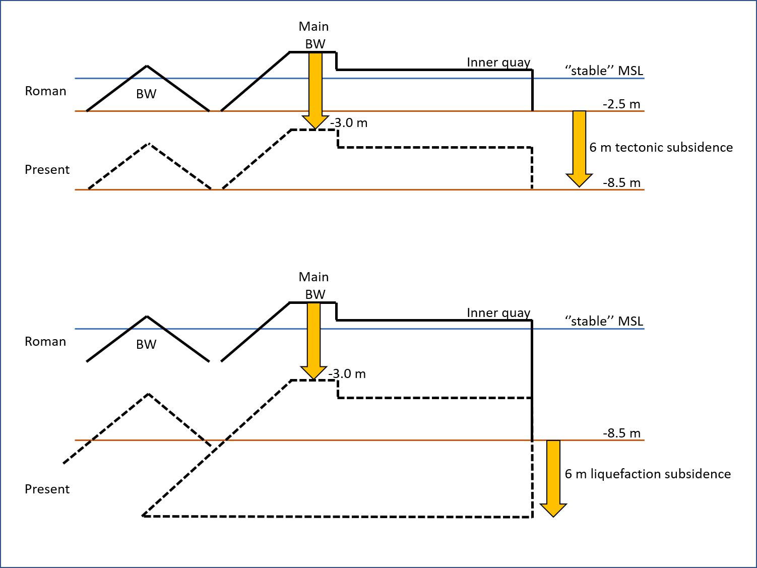
With an assumed tectonic subsidence of 6 m, the outer harbour structures would have been built on a 2.5 m water depth and the western breakwater would be ca. 6 m high from its foundation at -2.5 m to its crest at say +3.5 m. The remains of this are still visible under water today.
With a subsidence due to liquefaction and without any tectonic subsidence, the outer harbour structures would have been built on an 8.5 m water depth and the western breakwater would be ca. 12 m high from its foundation at -8.5 m to its crest at say +3.5 m. The remains of only the top of this structure would be still visible under water today, and a further 6 m of the structure would be buried in the sub-soil underneath.
The second option would be an unprecedented large marine structure in its time, but it would be closer to Josephus Flavius’ descriptions mentioning a water depth of 20 fathoms (36 m). Even if this value is probably exaggerated, it surely means “deep water”, i.e., more than the 2.5 m water depth of the first option. According to geologists (Sivan, 2010) and to Galili (2017, 2021), the tectonic subsidence option is out of the question in this area.
Hence, the earthquake-generated liquefaction option, possibly combined
with long-term compaction and consolidation,
is the only option remaining at this stage.
Further geotechnical study by means of corings might yield some new insights.
This scenario would explain how the breakwaters subsided into the underground, allowing offshore waves to penetrate the harbour basin, inducing its sedimentation, i.e., the port authorities witnessed meters of subsidence after one of the earthquakes (possibly 127-130 AD, 303 AD with tsunami, 363 AD, 419 AD, 425 AD) and refrained from further maintenance that would have been too costly, such as adding new layers of hydraulic concrete on top of the breakwater. The port of Caesarea lost its importance, as mentioned by Procopius of Gaza just before 500 AD, and the much older port of Akko, which did not suffer from subsidence, took over (Gertwagen, 2024).
.
References
GALILI, E., SALAMON, A., GAMBASH, G., ZVIELY, D., 2021, “Archaeological and Natural Indicators of Sea-Level and Coastal Changes: The Case Study of the Caesarea Roman Harbor”, Geosciences 2021, 11, 306, (26 p).
GALILI, E., 2017, “Ancient Harbors and Anchorages in Caesarea”, in “Ancient Caesarea, Conservation and Development of a Heritage Site”, Israel Antiquities Authority, Jerusalem, (p 11- 25).
GALILI, E., DAHARI, U., SHANIT, J., 1993, “Underwater surveys and rescue excavations along the Israeli coast”, International Journal of Nautical Archaeology (1993), 22.1, (p 61-77).
GOODMAN-TCHERNOV, B., AUSTIN, J., 2015, “Deterioration of Israel’s Caesarea Maritima’s ancient harbor linked to repeated tsunami events identified in geophysical mapping of offshore stratigraphy”, Journal of Archaeological Science, Reports, 3, (p 444–454).
NAVIS II, 2002, The Navis II Database Project, European Commission Directorate General X: https://www2.rgzm.de/navis2/home/frames.htm (go to Harbours/Harbour Information/Israel/Caesarea). This RGZM site does not function presently and will be transferred to www.leiza.de: https://www2.leiza.de/navis/
OLESON, J. & BRANDON, C. & HOHLFELDER, R. & JACKSON, M., 2014, “Building for Eternity – The history and Technology of Roman Concrete Engineering in the Sea”, Oxbow Books, (327 p).
RABAN, A., 1995, “The Heritage of Ancient Harbour Engineering in Cyprus and the Levant”, Cyprus and the sea, international symposium, Nicosia 25 – 26 September 1993, (p 139-188).
RABAN, A., 1996, “The Inner Harbour Basin of Caesarea: Archaeological Evidence for Its Gradual Demise”, chapter 38 in “Caesarea Maritima, a retrospective after two millennia”, ed. Brill, Leiden, (p 628-666).
RABAN, A., 2009, “The Harbour of Sebastos (Caesarea Maritima) in its Roman Mediterranean Context”, edt. Artzy, Goodman & Gal, BAR International Series N° 1930, Oxford, (222 p).
REINHARDT, E. & RABAN, A., 1999, “Destruction of Herod the Great’s harbor at Caesarea Maritima, Israel—Geoarchaeological evidence”, Geology, Vol. 24, N° 9.
SHTIENBERG, G. et al., 2016, “Late-Pleistocene evolution of the continental shelf of central Israel, a case study from Hadera”, Geomorphology 261 (2016), (p 200–211).
SIVAN, D., et al., 2010, “What can a sessile mollusk tell about neotectonics?”, Earth and Planetary Science Letters 296, (p 451–458).
VOTRUBA, G., 2007, “Imported Building Materials of Sebastos Harbour, Israel”, International Journal of Nautical Archaeology, 2007, 36.2, (p 325-335).
YASUR-LANDAU A, SHTIENBERG G, GAMBASH, G, SPADA G, MELINI D, ARKIN-SHALEV E, et al., 2021, “New relative sea-level (RSL) indications from the Eastern Mediterranean: Middle Bronze Age to the Roman period (~3800–1800 y BP) archaeological constructions at Dor, the Carmel coast, Israel”, PLoS ONE 16(6): e0251870, (25 p). https://doi.org/10.1371/journal.pone.0251870
ZVIELY, D., KIT, E., KLEIN, M., 2007, “Longshore sand transport estimates along the Mediterranean coast of Israel in the Holocene”, Marine Geology, 238 (1-4), (p 61-73).
Ancient references
The following ancient authors mention the port of Caesarea (in chronological order):
ZENON’s papyri (259-255 BC)
ANONYMOUS (2nd-1st c. BC), Stadiasmus, 272
STRABO (ca. 65 BD – 25 AD), Geogr, 16, 2
LUKE (1st c. AD), Acts, 18.22 & 21.8
JOSEPHUS FLAVIUS (37-100 AD), Jewish War, 1, 21 & Jewish Antiquities, 2, 2 & 15, 9
PROCOPIUS (ca. 500-560 AD), Anastasius, 19
Descriptions by Josephus Flavius
Jewish War, 1, 21 (or 410), dated around 78 AD
(transl. W. Whiston, 1737, London)
[…] for the case was this, that all the sea shore between Dora and Joppa, in the middle between which this city is situated, had no good haven, insomuch that every one that sailed from Phenicia for Egypt was obliged to lie in the stormy sea, by reason of the south winds that threatened them; which wind, if it blew but a little fresh, such vast waves are raised, and dash upon the rocks, that upon their retreat the sea is in a great ferment for a long way. But the king, by the expenses he was at, and the liberal disposal of them, overcame nature, and built a haven larger than was the Piraeus [at Athens]; and in the inner retirements of the water, he built other deep stations [for the ships also].
Now although the place where he built was greatly opposite to his purposes, yet did he so fully struggle with that difficulty, that the firmness of his building could not easily be conquered by the sea; and the beauty and ornament of the works were such, as though he had not had any difficulty in the operation: for when he had measured out as large a space as we have before mentioned, he let down stones into twenty fathom water, the greatest part of which were fifty feet in length, and nine in depth, and ten in breadth, and some still larger. But when the haven was filled up to that depth, he enlarged that wall which was thus already extant above the sea, till it was two hundred feet wide; one hundred, of which had buildings before it, in order to break the force of the waves, whence it was called Procumatia, or the first breaker of the waves; but the rest of the space was under a stone wall that ran round it. On this wall were very large towers, the principal and most beautiful of which was called Drusium from Drusus, who was son-in-law to Caesar.
There were also a great number of arches where the mariners dwelt; and all the places before them round about was a large valley, or walk, for a quay [or landing place] to those that came on shore; but the entrance was on the north, because the north wind was there the most gentle of all the winds. At the mouth of the haven were on each side three great Colossi, supported by pillars, where those Colossi that are on your left hand, as you sail into the port, are supported by a solid tower, but those on the right hand are supported by two upright stones joined together, which stones were larger than that tower which was on the other side of the entrance.
Jewish Antiquities, 15, 9 (or 331), dated around 93-94 AD
(transl. W. Whiston, 1737, London)
[…] and what was the greatest and most laborious work of all, he adorned it with a haven, that was always free from the waves of the sea. Its largeness was not less than the Piraeus [at Athens:] and had towards the city a double station for the ships. It was of excellent workmanship; and this was the more remarkable for its being built in a place that of itself was not suitable to such noble structures, but was to be brought to perfection by materials from other places, and at very great expenses. This city is situated in Phenicia; in the passage by sea to Egypt; between Joppa and Dora: which are lesser maritime cities, and not fit for havens; on account of the impetuous south winds that beat upon them: which rolling the sands that come from the sea against the shores, do not admit of ships lying in their station: but the merchants are generally there forced to ride at their anchors in the sea itself. So, Herod endeavoured to rectify this inconvenience: and laid out such a compass toward the land, as might be sufficient for a haven, wherein the great ships might lie in safety. And this he effected by letting down vast stones of above fifty foot in length; not less than eighteen in breadth, and nine in depth, into twenty fathoms deep: and as some were lesser, so were others bigger than those dimensions. This mole which he built by the sea side was two hundred foot wide: the half of which was opposed to the current of the waves, so as to keep off those waves which were to break upon them: and so was called Procymatia, or the first breaker of the waves: but the other half had upon it a wall, with several towers: the largest of which was named Drusus: and was a work of very great excellence, and had its name from Drusus, the son-in-law of Cesar, who died young. There were also a great number of arches where the mariners dwelt. There was also before them a quay, [or landing place,] which ran round the entire haven, and was a most agreeable walk to such as had a mind to that exercise. But the entrance or mouth of the port was made on the north quarter: on which side was the stillest of the winds of all in this place: And the basis of the whole circuit on the left hand, as you enter the port, supported a round turret; which was made very strong, in order to resist the greatest waves, while on the right hand, as you enter, stood two vast stones, and those each of them larger than the turret, which were over-against them. These stood upright, and were joined together.