Location: 36.84°N 10.33°E
Cicero (Agraria, Rullus, 2) wrote “Carthago succincta portibus” (Carthage surrounded by ports), which denotes a fairly complicated configuration (Ennabli, 2020, see also Wikipedia). Moreover, we are dealing with 1500 years of evolution (from ca. 800 BC to ca. 700 AD), mostly under the present soil and water levels … Our aim is to provide some synthetic information, with a few hypotheses and conjectures.
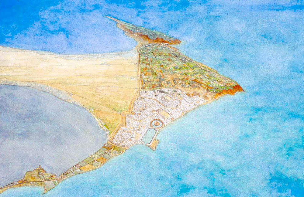
Note that sand is provided to the isthmus by R Medjerda to the north and R Miliane to the south.
Most of what we know today on the Roman ports of Carthage was summarised by Henry Hurst (2010). One might schematise Carthage’s port system by distinguishing three main port areas:
- Rectangular commercial port, in Salammbô area near the Phoenician Tophet,
- Circular military port (the Cothon), with the famous circular “ilôt de l’Amirauté”,
- Eastern shore area between “de Roquefeuil’s Quadrilateral” (north) and “Falbe’s Quadrilateral” (south).
Both first mentioned ports were located inside the city walls and closed by a chain (limen kleistos), and the third was located on the water edge outside the city-walls.
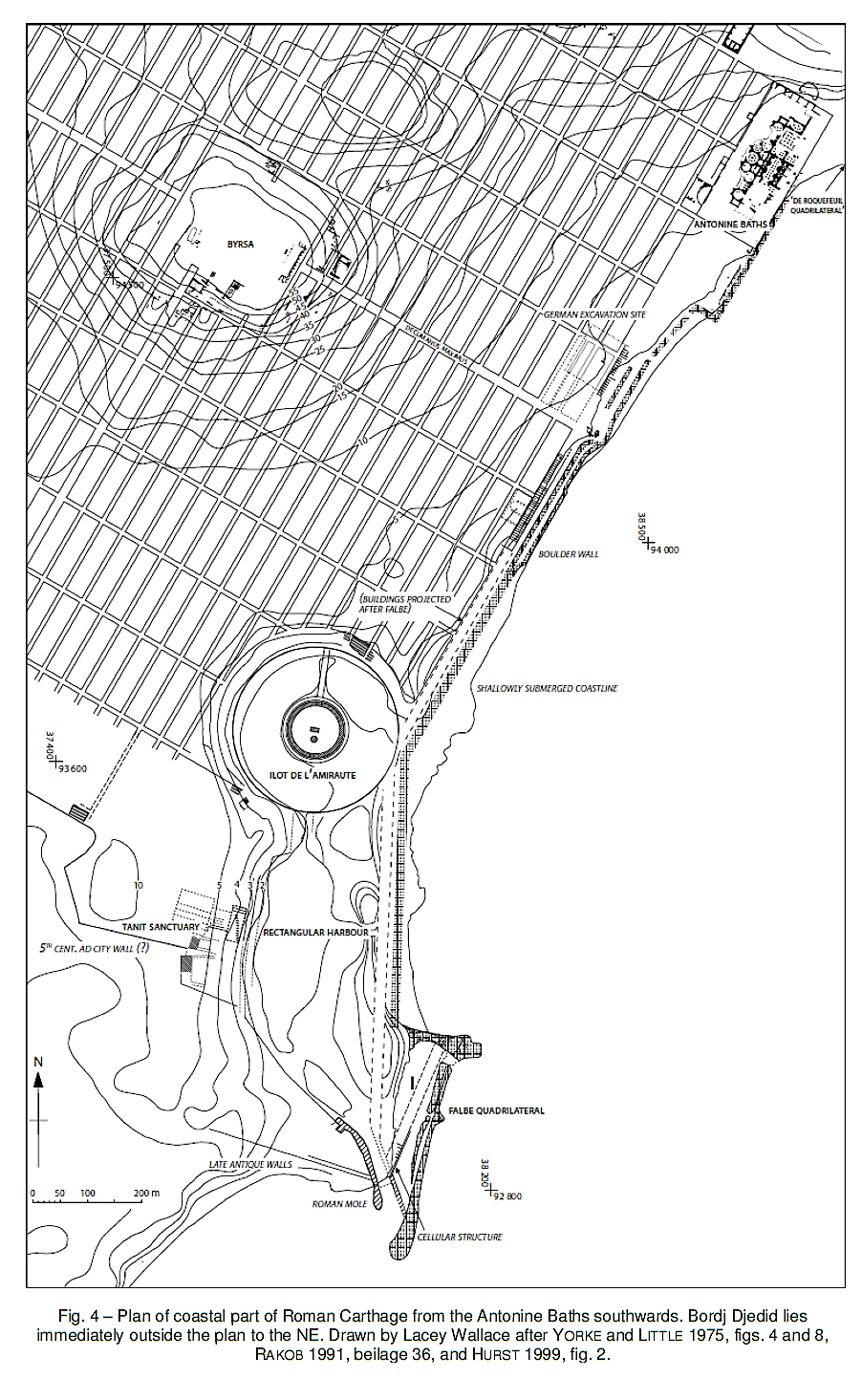
Note that de Roquefeuil’s Quadrilateral may not be ancient and that we have no evidence of a port at or underneath the Antonine baths.
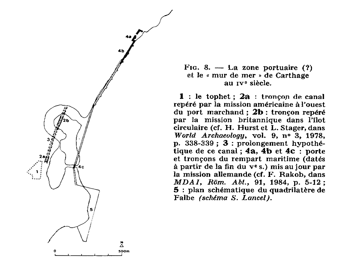
As far as we can reconstruct harbour evolutions today, Phoenicians from Sidon first settled near the Antonine baths during the Bronze Age, followed by Phoenicians from Tyre who landed on the beach in front of the Byrsa hill around 800 BC and built a fortified city on the hill. This landing place was outside the city walls, possibly sheltered by a sand spit growing from north to south as suggested by Ennabli (1992, p 200), and probably soon got some wooden landing stages. Some archaeological evidence was found by Hurst and Stager (1978), showing a 15 to 20 m wide and 2 m deep salt-water canal probably leading from the Tophet area to the circular port area.
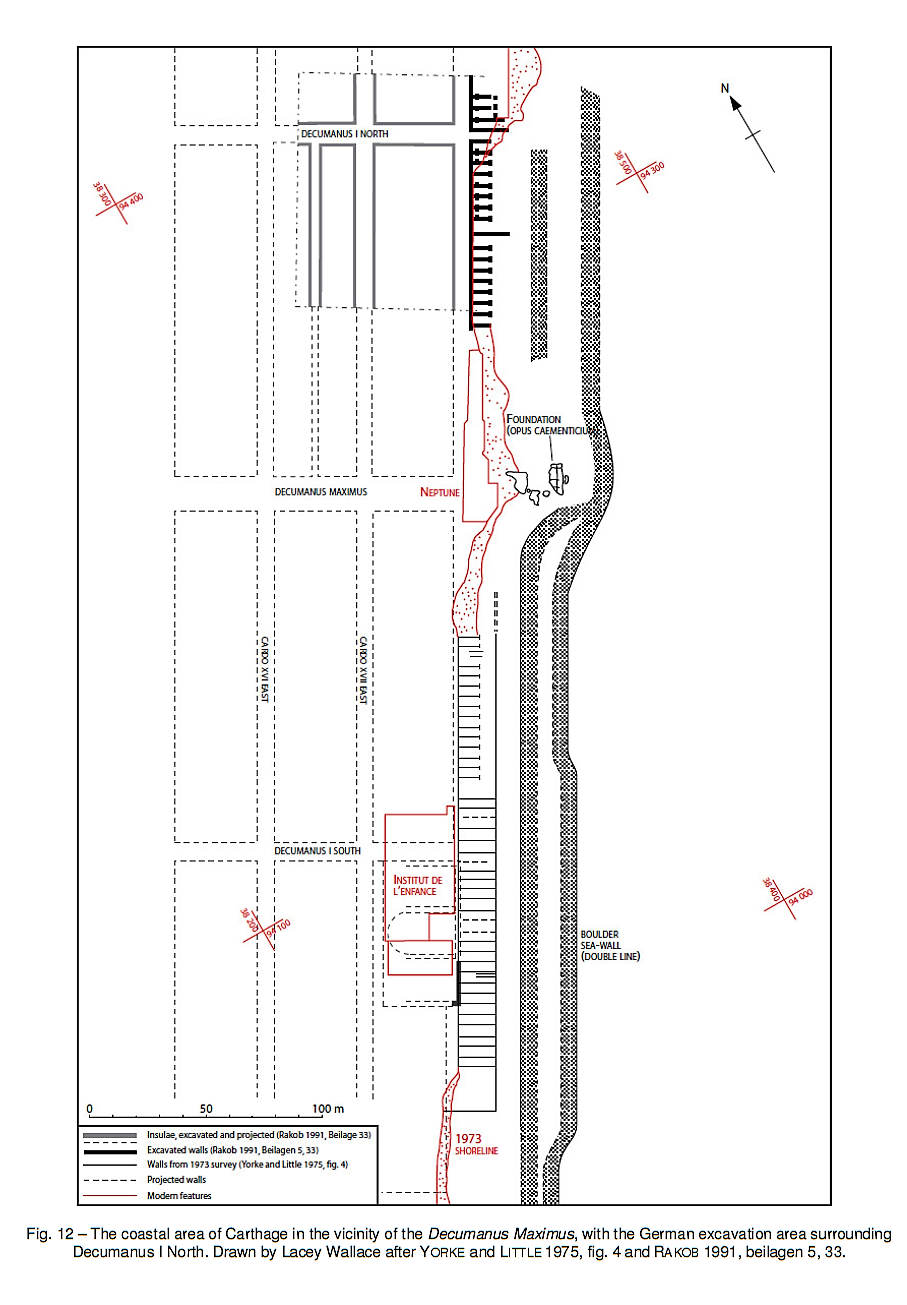
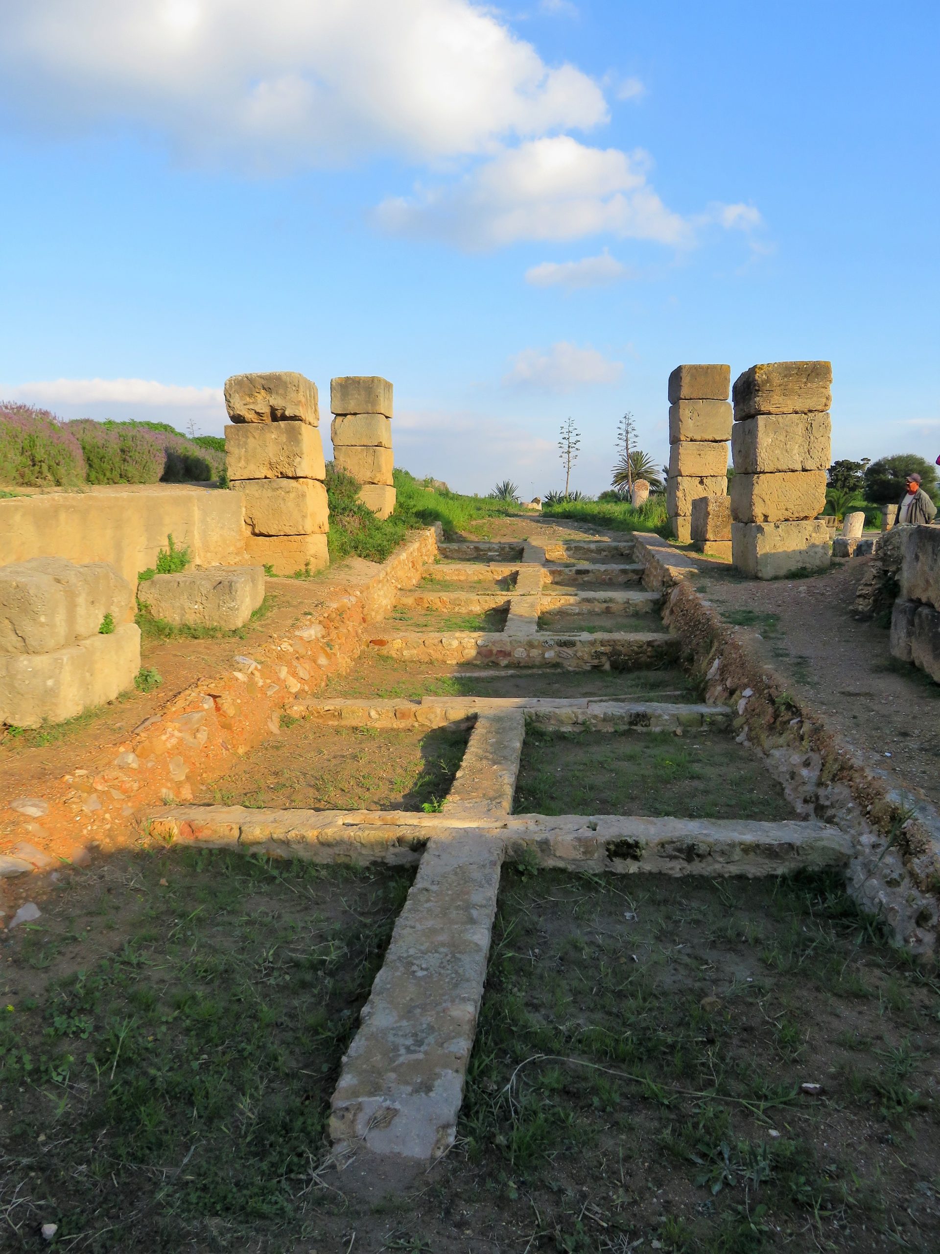
It is however still unclear where the beginning and ending of this canal was located and what may have been its use. According to Hurst (2010), the Lake of Tunis never had an important function as a port, and this canal was thus not used for navigation between the Lake and the Byrsa hill. Anyway, as this canal was silted-up and abandoned during the 4th c. BC (Hurst and Stager, 1978), it might be envisaged that a new harbour basin was dug somewhat further east in the 3rd c. BC, including the Punic quay that was traced for 50 m by Stager. This would later become the so-called ‘rectangular port’, with the very same quay still in use in Byzantine times.
Both the rectangular commercial port and the circular military port (the Cothon) were built inside the city walls and closed by heavy chains (Appian, Libyca, 96). The coastal part of the city wall was built around 400 BC (Rakob, in Ennabli, 1992), and had a city gate in Quartier Magon, proving there was much activity in that eastern shore area which extended ca. 50 m further out to sea (Paskoff, 1991). The rectangular port was built between 300 BC and 250 BC, and the circular port between 200 BC and 150 BC (Lancel, 1985 ; Ennabli, 1992). The north mole of the Falbe Quadrilateral, located near the southern end of the rectangular port was also built in Punic times and possibly used as a breakwater protecting the entrance of the ports (Hurst, 2010).
After the Roman conquest (146 BC), the city was first destroyed, and after one century, Caesar ordered its reconstruction (44 BC). Both the rectangular and the circular ports were soon refurbished as commercial ports, but their water depth was limited to a couple of meters. Around 100 AD, the rectangular basin was changed into an elongated hexagon, similar to Trajan’s basin at Portus. We might conjecture that the Roman cellular structures located east of the Byrsa hill were built on top of (or behind) the ancient Punic city wall in order to provide Rome with olive oil and grain during the first centuries AD and that larger ships could moor in that area and near the “Choma” of Falbe’s Quadrilateral. However, this area may have been undermined by wave action and was finally abandoned for shipping. A two-line coastal protection would then have been built in the 5th or 6th c. AD to protect the city from erosion due to wave action. At that time, the remaining double port system was called “Mandrakion (Mandracium)” by Procopius (Vandals, 1, 20).
Eastern shore area. According to de Roquefeuil’s hydrographic chart (in Hurst, 2010) and to modern investigations, the seabed in this area is rocky with an occasional thin sand cover. This sand is most probably provided by R Medjerda to the north and R Miliane to the south (further sedimentological analysis might prove this) and quantities may fluctuate with the river discharges of sediment. Paskoff et al. (1991) explain that the sediment discharge of rivers was reduced after the Roman occupation because of a reduction of deforestation yielding a reduction of inland soil erosion (further geo-archaeological corings might prove this). This would open the door to coastal erosion and the initial sand spit mentioned above might have disappeared.
In order to understand erosion by wave action on the eastern shore, we must have a closer look at the wind and wave conditions. The wind climate which was studied for the port of Thapsus. From Bizerte to Cap Bon (and even Nabeul) prevailing winds are from NW all year round. East and NE winds prevail only south of Nabeul and all the way down to Djerba.
This means that in ancient times, Carthage’s eastern shore area was on open sea but that it was fairly protected from prevailing NW storms and could be used for beaching ships. It would later have been used (perhaps for short stops of ships) in conjunction with the inner port after the latter was built. As this shore could be attacked by NE waves, we might conjecture that it has been eroded, so that it finally had to be protected by rubble. The second line of rubble defence was possibly added somewhat later. (Hurst, 2010, calls it “boulder seawall”). The result was that no ship could reach the eastern shore anymore.
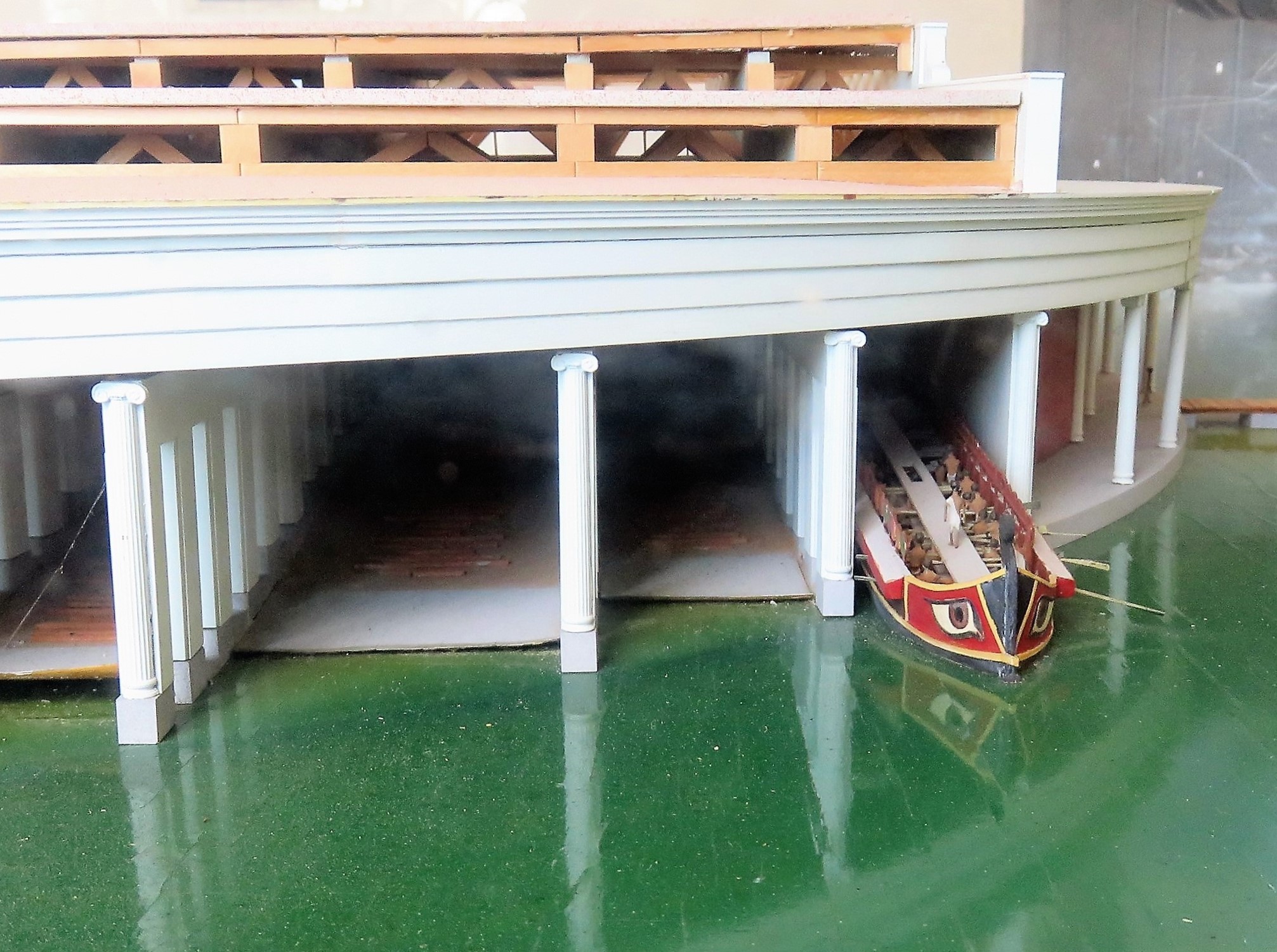
Inner ports area. Both the rectangular and the circular ports obviously survived better than the eastern shoreline as they were protected from the sea. The circular port was studied by many archaeologists. It was called “the Cothon” because of its saucer-like shape, more than because it was a man-made dug-out harbour basin (Carayon, 2017). Both the outer perimeter and the central islet were filled with slipways with shipsheds (Blackman, 2013), before becoming a market place in Roman times.
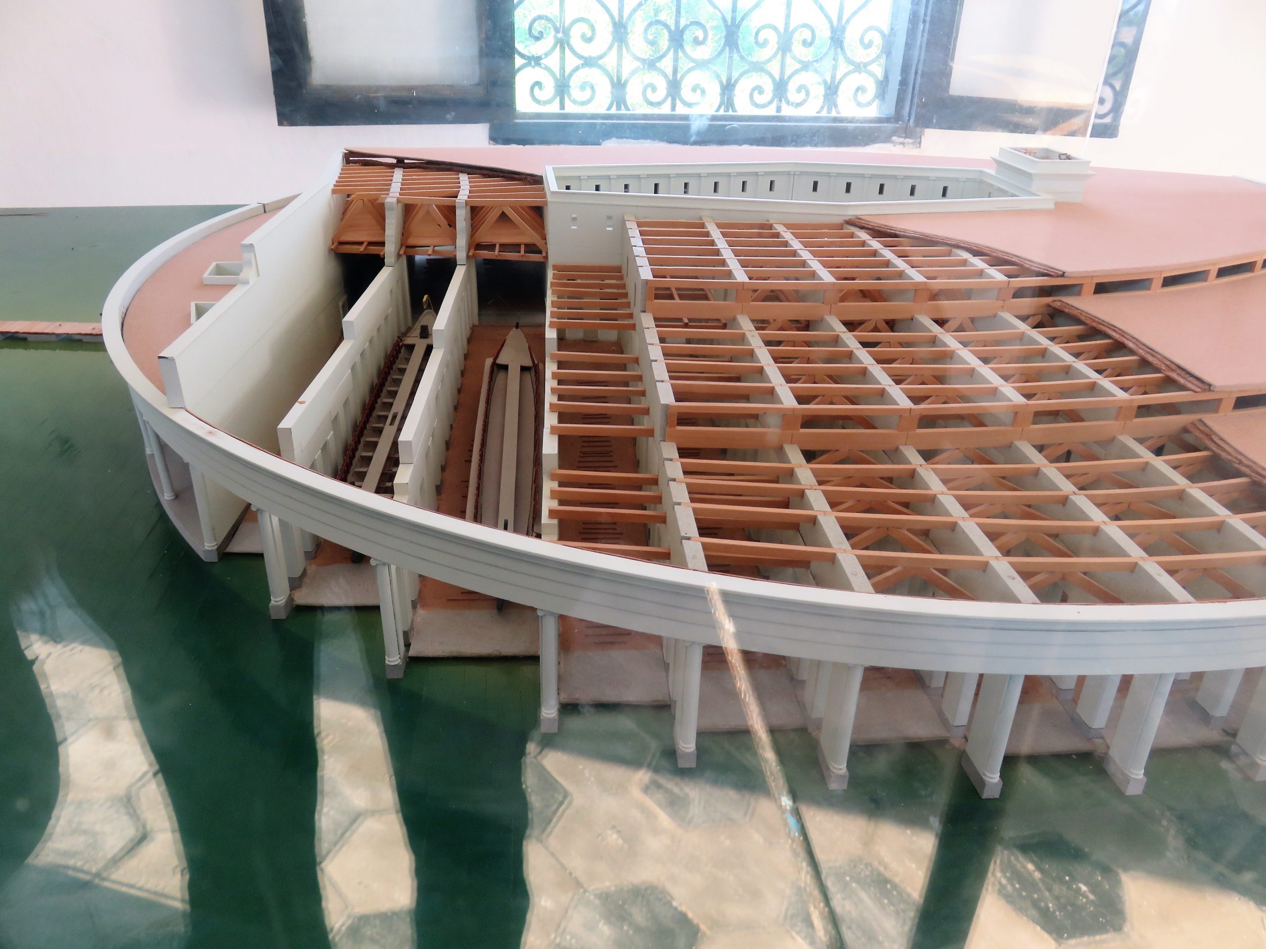
Harbour entrance. It has been shown that the northern edge of Falbe’s Quadrilateral is Punic. It reaches ca. 75 m in the sea in an eastward direction. Such a short breakwater provides limited shelter against north and NW waves for a small number of ships (say five), and no shelter for other wave directions. It might be conjectured that this breakwater was built in Punic times to provide a sheltered access to the inner rectangular port. It was later included into a Roman platform that was called Falbe’s Quadrilateral in the 20th c. and where another Roman cellular structure was found by Yorke & Little (1975). The Roman entrance to the rectangular port was thus relocated southwards where large blocks of Roman hydraulic concrete (opus caementicium) were found by Hurst (2010, fig. 8).
Further (fascinating) reading on:
https://www.romanports.org
References
AOUNALLAH, S., 2020, “Carthage, Archéologie et histoire d’une métropole méditerranéenne, 814 avant J.-C. – 1270 après J.-C.”, CNRS Editions, (220 p).
BLACKMAN, D. & RANKOV, B., et al., 2013, “Shipsheds of the Ancient Mediterranean”, Cambridge University Press, (617 p).
CARAYON, N., et al., 2017, “Kothon, cothon et ports creusés”, MEFRA, 129/1, (p 255-266).
ENNABLI, A., 1992, “Pour sauver Carthage – Exploration et conservation de la cité punique, romaine et byzantine”, UNESCO/INAA, Paris, (252 p).
ENNABLI, A., 2020, “Carthage. Les travaux et les jours – Recherches et découvertes, 1831-2016”, CNRS Editions, (496 p).
HURST, H. & STAGER, L., 1978, “A metropolitan landscape: The late Punic port of Carthage”, World Archaeology, 9:3, (p 334-346).
HURST, H., 2010, “Understanding Carthage as a Roman Port”, Bollettino di Archeologia on line I 2010/ Volume speciale B/B7/6, (p 49-68).
LANCEL, S., 1985, “La renaissance de la Carthage punique. Réflexions sur quelques enseignements de la campagne internationale patronnée par l’Unesco”, Comptes rendus des séances de l’Académie des Inscriptions et Belles-Lettres, 129ᵉ année, N° 4, 1985. (p 727-751).
PASKOFF, R., SLIM, H., TROUSSET, P., 1991, “Le littoral de la Tunisie dans l’Antiquité : cinq ans de recherches géoarchéologiques”, Comptes rendus des séances de l’Académie des Inscriptions et Belles-Lettres, 135ᵉ année, N° 3, 1991, (p 515-546).
WIKIPEDIA: https://en.wikipedia.org/wiki/Carthage
YORKE, R. & LITTLE, J., 1975, “Offshore survey at Carthage, Tunisia, 1973”, International Journal of Nautical Archaeology and Underwater Exploration (1975), 4.1, (p 85-101).