The main sailing routes have been deduced from ancient texts (Arnaud, 2005)[1] and from modern ‘Pilots’ used by yachtsmen. Indeed, the meteorological sailing conditions are considered to be fairly unchanged over the past few millennia. Wind speed and direction are of paramount importance for sailing, as Mediterranean currents play a secondary role and high waves are avoided as much as possible.
The prevailing wind direction almost everywhere on the Mediterranean Sea is NW.
Note that ‘prevailing’ usually means ‘over 50% of time’, but not 100%!
In addition, a constant wind direction is required for long-haul offshore sailing. This is typically the case from Sicily to Alexandria in summer time, but other prevailing wind directions may exist locally, e.g. north on the Aegean Sea, north and NE on the Black Sea and east along the coasts of Algeria. Obviously, some finer analysis is needed to find a way back to Rome from Alexandria. This trip is achieved by using sea breezes blowing in the afternoon from the sea to the land[2]. These winds are best felt within a few miles off the coast. They blow more or less perpendicular to the coast, but may locally reach an angle of 45° or even be parallel to the coast.
So here is the conclusion:
Going east can be achieved by long-haul offshore sailing,
and going west has to be done with more coastal navigation.
The trip to Rome is therefore much longer than the trip to Alexandria as it is not only longer in distance, but it also involves much waiting for favourable wind conditions: one or two weeks sailing to Alexandria, but at least double when sailing back to Rome.
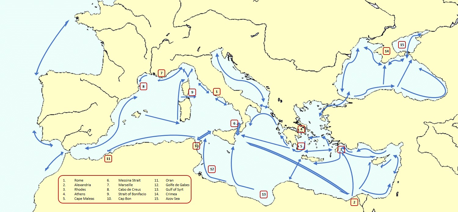
The trip from Alexandria to Rome goes north directly to Rhodes, or along the Levantine coast and then west along the southern Cypriot coast, but some will make a direct route to Cyprus using the westerlies. In any case, sailing from Cyprus to Rhodes is difficult due to adverse winds[3]. The Aegean Sea is famous for its northern wind called Meltemi[4] which makes its east-west crossing a subtle operation using local winds around the islands. The route through the Aegean Sea is still a matter of debate, some favour the northern route, but those not going to Athens prefer the southern route avoiding the dangerous Cape Maleas. West of the Peloponnesus, the Ionian Sea with prevailing NW winds has to be crossed, either directly to the Messina Strait, or by following the Greek coast before crossing over to Calabria. An alternative to this Aegean route is the Libyan route along the coasts of Cyrenaica, Libya and Malta or Tunisia (mainly in May and in October, in order to avoid the northwestern “etesian winds”).
The western Mediterranean is subjected to low pressures travelling from west to east and inducing a counter clockwise wind pattern. Hence, on the French south coast, the wind will blow from south to east first, then turn to north to NW, generating the famous Mistral and Tramontana. This explains that it can be difficult to sail from Marseille to Cabo de Creus and that this has to be done close to the coast to avoid high offshore waves induced by the Tramontana. The trip back may lead through the Baleares and Sardinia, where the westerlies will prevail, then along the western coasts of Sardinia and Corsica where a southern wind may blow. Those going to Rome will take the dangerous Straits of Bonifacio between Sardinia and Corsica.
The coast of North Africa is prone to summer easterlies between Cap Bon and Oran, but lack of wind between Oran and Gibraltar … in addition to adverse east going surface currents of Atlantic water compensating the Mediterranean evaporation.
The Tunisian Golfe de Gabes and Libyan Gulf of Syrt have a tidal range up to 1 m inducing tidal currents that can be used by sailors in both directions. The summer winds may blow from north to east.
The access to the Black Sea is very difficult because of the strong southward surface current of fresh water flowing towards the Mediterranean Sea, in addition to NE winds[5]. Inside the Black Sea, currents flow counter-clockwise and favour a trip to the east along the Turkish coast, before crossing over to Crimea against prevailing winds. Nevertheless, ancient seafarers are known to have sailed massively along the western Black Sea coast to Crimea and to the Azov Sea, possibly because this trip was free of pirates.
The need for a large number of shelters follows from the fact that sailors may need to wait for proper wind conditions or may try to escape bad weather conditions. Even though they can sail 50 to 100 nautical miles in a day (see Ancient Measures), it is important to know where they can find a safe shelter within two to three hours of navigation, i.e. only approx. 10 miles.
It has hopefully been made clear in this (very) brief survey of Mediterranean sailing that it is a vast and complicated subject that requires a lot of experience. History shows that Mycenaeans (ca. 1500-1200 BC), Phoenicians (ca 1200-150 BC) and Greeks (ca. 800-300 BC) were very good at that. Mycenaean sailors had a very difficult playground in the Aegean Sea. Perhaps their experience was later taken over by Phoenicians who used it to travel all over the Mediterranean Sea and beyond.
Notes
[1] ARNAUD, P., 2005, “Les routes de la navigation antique”, éd. Errance.
[2] Sea breezes blow from sea to shore in the afternoon, easing the arrival to harbours. Land breezes blow during the night and early morning easing departure from the harbour.
Acc. to Rod Heikell in “The Adlard Coles Book of Mediterranean Cruising”, 2012, Chap 6, p 312-313:
“1. The relatively high temperatures of the Mediterranean mean that sea breezes are not the gentle zephyrs encountered in more temperate climes. In many places, the temperature differences generate winds up to Force 5–6 and can reach up to 50 miles off the coast.
2. There is a fairly accurate wind clock for the sea breeze. As the land warms up in the morning the sea breeze will begin to blow at 1100–1200 local time at around Force 2–3. Usually within an hour the wind will get up to Force 4–6 and will blow through the afternoon until early evening. The wind will die off fairly quickly around 1900–2000 local time. The abruptness of the change is linked to the air temperatures and geography of a region. In general, the higher the temperature, the more abrupt the transition between morning calm and the onset of the full force of the sea breeze. The terrain affects the sea breeze according to altitude: low-lying plains or gentle S-facing slopes will heat up more quickly than mountain ranges with valleys in shadow for much of the day and so generate greater pressure differences and stronger winds.
3. The direction the coast faces will affect the sea breeze clock. In general S-facing coasts will have an earlier sea breeze than N-facing coasts. Likewise, E-facing coasts will have an earlier sea breeze than W-facing coasts.”
It may be added here that coastal effects modify the wind direction and strength, e.g. around a headland with high land where the wind will follow the shore and curve around the headland with an increased speed.
[3] Lucian of Samosata (2nd c. AD) tells the fascinating story of a very large grain freighter caught in a storm off Cyprus:
“I had it from the master, a nice intelligent fellow to talk to. They set sail with a moderate wind from Pharos, and sighted Acamas on the seventh day. Then a west wind got up, and they were carried as far east as Sidon. On their way thence, they came in for a heavy gale, and the tenth day brought them through the Straits to the Chelidon Isles; and there they very nearly went to the bottom. I have sailed past the Chelidons myself, and I know the sort of seas you get there, especially if the wind is SW.
It is just there, of course, that the division takes place between the Lycian and Pamphylian waters; and the surge caused by the numerous currents gets broken at the headland, whose rocks have been sharpened by the action of the water till they are like razors; the result is a stupendous crash of waters, the waves often rising to the very top of the crags.
This was the kind of thing they found themselves in for, according to the master, and on a pitch-dark night! However, the Gods were moved by their distress, and showed them a fire that enabled them to identify the Lycian coast; and a bright star–either Castor or Pollux–appeared at the masthead, and guided the ship into the open sea on their left; just in time, for she was making straight for the cliff. Having once lost their proper course, they sailed on through the Aegean, bearing up against the Etesian winds, until they came to anchor in Piraeus yesterday, being the seventieth day of the voyage; you see how far they had been carried out of their way; whereas if they had taken Crete on their right, they would have doubled Malea, and been at Rome by this time.”
[4] Acc. to Rod Heikell in “The Adlard Coles Book of Mediterranean Cruising”, 2012, Chap 6, p 313: “From the Dardanelles it blows from the NE, curving down through the Aegean to blow from the N and NW before curving to blow from the W around Rhodes.”
[5] CASTELLI, T., 2019, “Entrer et sortir du Pont-Euxin durant l’Antiquité”, Advances in Ancient Black Sea Studies: Historiography, Archaeology and Religion, Editura Mega, Constanza, (26 p).