Location: 31°N 31°E
Our aim in this short study is to put some order into the various ancient branches and outlets of the Nile … An almost impossible task as archaeology can help finding the location of ancient water courses and even dating them, but it will usually not provide their names (with the notorious exception of ‘Darius’ canal’, also called ‘Necho’s canal’).
But let’s try by starting with the pre-dynastic Nile Delta.
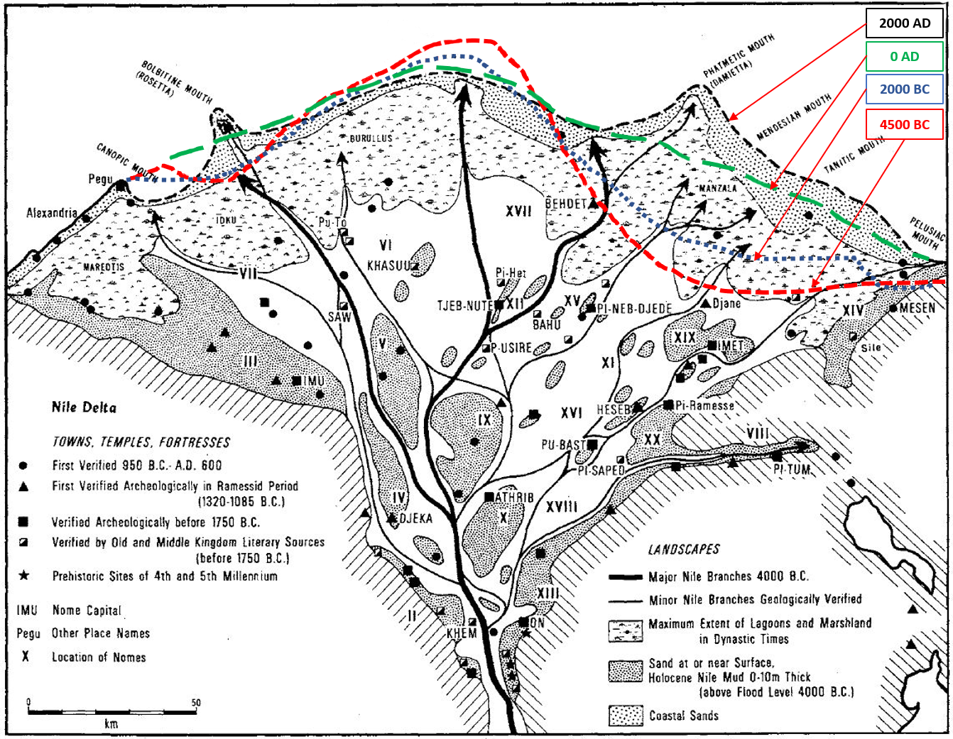
As shown in the figure above, the Nile flowed straight to the north from Memphis towards modern Baltim, via ancient Athribis, Bousiris and Sebennytos. The bell-shaped coastline shows the effect of massive sedimentation around this main outlet of the “Great River” Nile. Sediment was moved eastward along the coastline due to action of dominant waves from NW. When this central Nile branch lost power, the Damietta branch took over and sediment accumulated in the eastern part of the Delta (Stanley, 2017). In addition, two lateral branches existed already at an early time: the Pelusiac branch to the east, and the Canopic branch (also called Herakleotic branch) to the west.
This description is very close to Herodotus’ one.
Nile Delta acc. to Herodotus (History, book 2, chap. 17), ca. 450 BC
(source: Loeb Classical Library, 1920, https://penelope.uchicago.edu/Thayer/E/Roman/Texts/Herodotus/2A*.html )
Now as far as the city Kerkasoros [north of Memphis] the Nile flows in one channel, but after that it parts into three. One of these, which is called the Pelusian mouth, flows eastwards; the second flows westwards, and is called the Canopic mouth. But the direct channel of the Nile, when the river in its downward course reaches the sharp point of the Delta [i.e., the apex of the triangle, near Memphis], flows thereafter clean through the middle of the Delta into the sea; in this is seen the greatest and most famous part of its waters, and it is called the Sebennytic mouth. There are also two channels which separate themselves from the Sebennytic and so flow into the sea, by name the Saïtic and the Mendesian. The Bolbitic and Bucolic mouths are not natural but dug channels.
From Herodotus, we understand that at least four other branches exist in addition to the three main branches, leading to a total of seven branches.
A similar picture is provided by Strabo, about four centuries later, where seven outlets are still mentioned, but it is noteworthy that he mentions three main branches (Pelusiac, Pathmitic and Canopic-Herakleotic), with other outlets in-between.
Nile Delta acc. to Strabo (Geography, book 17, chap. 1), ca. 25 BC
(source: https://penelope.uchicago.edu/Thayer/E/Roman/Texts/Strabo/17A1*.html )
[4] The Nile flows from the Aethiopian boundaries towards the north in a straight line to the district called “Delta,” and then, being “split at the head,” as Plato says, the Nile makes this place as it were the top of a triangle, the sides of the triangle being formed by the streams that split in either direction and extend to the sea – the one on the right to the sea at Pelusium and the other on the left to the sea at Canopus and the neighbouring Herakleium, as it is called, – and the base by the coast-line between Pelusium and the Herakleium. […] Now these are two mouths of the Nile, of which one is called Pelusiac and the other Canopic or Herakleotic; but between these there are five other outlets, those at least that are worth mentioning, and several that are smaller; for, beginning with the first parts of the Delta, many branches of the river have been split off throughout the whole island and have formed many streams and islands, so that the whole Delta has become navigable. […]
[18] After Canopus, one comes to the Herakleium, which contains a temple of Heracles; and then to the Canopic mouth and the beginning of the Delta. […] After the Canopic mouth one comes to the Bolbitic mouth, and then to the Sebennytic, and to the Pathmitic, which is third in size as compared with the first two which form the boundaries of the Delta [the Canopic and Pelusiac branches]; for not far from the vertex of the Delta, the Pathmitic splits, sending a branch into the interior of the Delta. Lying close to the Pathmitic mouth is the Mendesian; and then one comes to the Tanitic, and, last of all, to the Pelusiac. There are also others in among these, pseudo-mouths as it were, which are rather insignificant. Their mouths indeed afford entrance to boats, but are adapted, not to large boats, but to tenders only, because the mouths are shallow and marshy. It is chiefly, however, the Canopic mouth that they used as an emporium, since the harbours at Alexandria were kept closed, as I have said before. After the Bolbitic mouth one comes to a low and sandy promontory [or bay?] which projects rather far into the sea; it is called Agnu-Ceras. And then to the Watch-tower of Perseus and the Wall of the Milesians; for in the time of Psammitichus (who lived in the time of Cyaxares the Mede) the Milesians, with thirty ships, put in at the Bolbitic mouth, and then, disembarking, fortified with a wall the above-mentioned settlement; but in time they sailed up into the Saïtic nome, defeated the city Inaros [unlocated] in a naval fight, and founded Naucratis, not far above Schedia. After the Wall of the Milesians, as one proceeds towards the Sebennytic mouth, one comes to two lakes, one of which, Boutic, has its name from the city Bouto, and also to the Sebennytic city, and to Saïs, the metropolis of the lower country.
Another ancient author is Chaeremon of Alexandria (Book of Phtomyris, book 2, chap. 73), ca. 85 AD, who was born in Naucratis, more or less confirms the above descriptions.
Ptolemy[1] adds a distinction between “outlets” (or mouths) and “branches”.
Nile Delta acc. to Ptolemy (Geography, book 4, chap. 5), ca. 150 AD
(source: Brady Kiesling, https://topostext.org/work/209 )
[4.5.10] The seven mouths of the Nile [with Longitude , Latitude in degrees, minutes]:
the Herakleotic or Canopic mouth: 60°50′ , 31°05′
the Bolbitic mouth: 61°15′ , 31°05′
the Sebennytic mouth: 61°30′ , 31°05′
the Pineptimi pseudo-mouth: 61°45′ , 31°05′
the Diolkos pseudo-mouth: 62°10′ , 31°10′
the Pathmitic mouth: 62°30′ , 31°10′
the Mendesios mouth: 62°45′ , 31°10′
the Tanitic mouth: 63°00′ , 31°15′
the Pelusiac mouth: 63°15′ , 31°10′
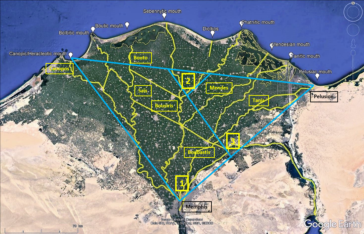
[4.5.39] The so-called Great Delta begins where the Agathodaimon branches off from the Great river and flows through the Herakleotic mouth [and ends] into the so-called Boubastic, which flows out through the Pelusiac mouth. The position of the fork of the Delta is 62°00′ , 30°00′ [Memphis-Babylon is located by Ptolemy at 62°15’ , 30°00’]
[4.5.40] The so-called Little Delta is where the Boubastic river splits into the Bousiritic river, which flows out through the Pathmitic mouth, position of which [fork] is 62°40′ , 30°20′ [north of Bousiris which is located by Ptolemy at 62°30’ , 30°15’, probably at Sebennytos located at 62°20′ , 30°20′].
[4.5.41] One might even mention a third delta somehow between the two aforementioned, where the Boubastic forks into the one that flows through Athribis city and the Pineptimi mouth. This is at 62°15′ , 30°05′ [a few km north of Memphis-Babylon which is located by Ptolemy at 62°15’ , 30°00’].
[4.5.42] At the Great Delta two rivers branch off toward the north from the river Agathodaimon; the first is called the Thermouthiac or Phermouthiac river, which flows out through the Sebennytic mouth; its fork is at 61°30′ , 30°15′ [south of Nikiou which is located by Ptolemy at 61°30’ , 30°20’].
[4.5.43] Second is the so-called Taly river, which flows through the Bolbitic mouth; the branching of the Taly river is at 61°00′ , 30°50′ [Hermopolis Mikra is located by Ptolemy at 61°00’ , 30°50’].
[4.5.44] The Boutic river which runs along at a nearly equal distance from the seacoast joins the Thermouthiac, the Athribitic, the Bousiritic and the Boubastic, from which others springing from adjacent marshes and lakes flow into the sea through the remaining mouths, some of which are connected, as we have said, with the Great river.
The main features of Ptolemy’s description are a) a list of coordinates of 7 river outlets and 2 pseudo-outlets (chap. 4.5.10), b) a list of river names with coordinates of 4 forks (embranchments, confluents) (chap. 4.5.39 to 43) and c) a stream flowing in an east-west direction (chap. 4.5.44). In addition, Ptolemy provides a description of the nomes and major cities of Delta in his chapters 4.5.46 to 4.5.54.
In order to locate the 4 forks mentioned by Ptolemy, we added the names of the nearest ancient cities according to Ptolemy’s own coordinate system in brackets ([city]).
These texts are referring directly to rivers and outlets, but other texts also refer indirectly to them (Redon, 2018).
River outlets
We know that Ptolemy was somewhat mistaken on his longitudes (see https://www.ancientportsantiques.com/ancientmaps/#2 ) but the distances between two places may give a valuable indication. Furthermore, we know that one minute of longitude (1’ = 1/60 degree) near Alexandria is ca. 1570 m.
Ptolemy’s longitudes of the Canopic and Pelusiac mouths are respectively 60°50′ and 63°15′, that is an east-west distance of 2°25’, or 145’, or 228 km. If we place the Canopic mouth at Izbat as Sittin (31.28°N, 30.15°E), just east of the recently discovered ancient city of Thonis-Herakleion (Goddio, 2007) and measure an east-west distance of 228 km, we end up within a few kilometres of the ruins of Pelusion. This confirms that the scale of Ptolemy’s east-west distances is quite correct in the Nile Delta and that we might try to locate other river outlets with his longitudes.
River forks
Although the above shows quite a good accuracy for east-west positioning of river outlets, we shall avoid further use of Ptolemy’s coordinates as we know that each time this was attempted in the past, it ended up in a very distorted picture because of the many approximations (and possible errors) in his data (Litinas, 2015). We shall rather use his coordinates to locate ancient cities, the locations of which are known in the modern WGS 84 coordinate-system (EES Delta Survey, 2016).
Even the location of the upstream fork where the Nile first splits into branches at the apex of the Delta near Memphis-Babylon-Kerkasoros (Greater Cairo) is a subject of discussion for Mark Lehner (2020) in his search for the early pharaonic ports near Gizeh.
River branches
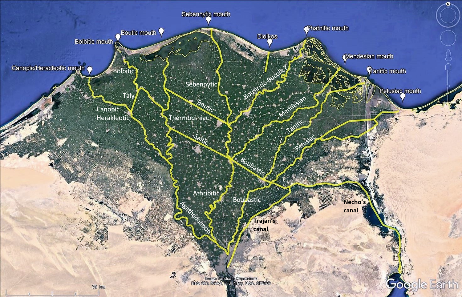
Quite clearly, the names of the river branches are related to the cities they were leading to. At this stage, we may try to put some order into the available data by listing branches and outlets from west to east:
| Name of river branch | Fork location (confluence) | Name of river outlet | Ptolemy’s distance east of Canopic mouth | Name/location of modern outlet | Ancient authors |
| Agathodaimon, Herakleotic branch | Memphis- Babylon (or Kerkasoros?) | Canopic mouth, Herakleotic mouth | 0 km | Izbat as Sittin, west of the port of Maadiyya | Ht St Pt |
| Taly Potamos | Hermopolis Mikra | Bolbitic branch | Pt | ||
| Bolbitic branch | South of Cabasa? | Bolbitic mouth | 39 km | Rosetta is at only 27 km | Ht St |
| Thermouthiac, Phermouthiac branch | South of Nikiou | Boutic mouth (Sebennytic mouth: Pt) | 63 km | Bouto is at 56 km | St Pt |
| Great River Athribitic branch, Sebennytic branch | Memphis- Kerkasoros | Sebennytic mouth (Pineptimi pseudo-mouth: Pt) | 86 km | Baltim is at 89 km | Ht St Pt |
| Boutic branch | Sebennytos? | Thermouthiac branch | Pt | ||
| Saïtic branch | Natho? | Thermouthiac branch? | Ht | ||
| Perhaps an ancient track of the Bousiritic branch? or the man-made Bucolic branch? | Diospolis Inferior? | Diolkos pseudo-mouth | 126 km | Gamasa is at 133 km | Pt Ht |
| Bousiritic branch | Sebennytos, near Bousiris | Pathmitic mouth | 157 km | Damietta is at 157 km | Pt |
| Mendesian branch | ? | Mendesian mouth | 181 km | Birket el-Amriti? At 181 km | Ht Pt |
| Tanitic branch | ? | Tanitic mouth | 204 km | Port Saïd is at 205 km | Pt |
| Boubastis branch | Memphis- Kerkasoros | Sebennytic branch at Sebennytos | Pt | ||
| Pelusiac branch | Near Boubastis | Pelusiac mouth | 228 km | Pelusion | Ht St Pt |
Both Herodotus and Ptolemy mention the Canopic and the Pelusiac outlets. The Herakleotic branch leads from Memphis to Naucratis, to Hermopolis Mikra and to the Herakleotic (Canopic) mouth. The track of the Pelusiac branch is less certain, especially near the Pelusiac mouth, and it must be remembered that the pre-dynastic coastline was far inland in this area, probably on a line from Herakleopolis Mikra to Panephysis (Bietak, 1975, 2011; Chartier Raymond, 1992; Stanley, 1998).
Herodotus adds that the Sebennytic outlet, yielding the largest stream of the “Great River”, flows straight north of Memphis to Athribis, Natho, Bousiris and Sebennytos. The outlet must be near Paralios (modern Baltim) as this area shows the largest accretion pushing the coastline to the north (Stanley, 1998). Herodotus’ Sebennytic outlet must therefore be the same as Ptolemy’s Pineptimi “pseudo-outlet”. This peculiar way of calling this outlet a pseudo-outlet might be due to the fact that this outlet was already clogged in his time. This makes sense from a hydraulic point of view, as the Sebennytic branch was getting just too long and was thus hampered by a large hydraulic resistance which would favour other branches like the Mendesian and the Tanitic branches which were the shortest way to the sea at that time. Massive sedimentation of the eastern side of the Delta would occur as from that time (Stanley, 1998). In a similar way, the Diolkos pseudo-outlet is possibly an ancient sedimented outlet that was used as a slipway for ships in Ptolemy’s time. It could also be the man-made outlet of the Bucolic branch mentioned by Herodotus which would flow from Diospolis Inferior near the Bousiritic branch, to the sea.
In the western Delta area, Ptolemy mentions the Taly Potamos flowing to the Bolbitic outlet (probably via the Bolbitic branch) after splitting off from the Herakleotic branch near Hermopolis Mikra. However, he does not mention the Saïtic branch and we do not know where was its outlet. After splitting off from the Herakleotic branch south of Nikiou, the Thermouthiac branch flows to Strabo’s Boutic outlet, near Bouto (Wilson, 2012) which is called “Sebennytic mouth” by Ptolemy.
Herodotus’ Saïtic branch is not mentioned by Ptolemy, but from Herodotus’ description, we might conjecture that this branch might be a link between the central Great River (Sebennytic branch) and the western branch (Thermouthiac branch) flowing to the west from Natho to Saïs via Tawa. Similarly, Herodotus’ Mendesian branch would flow to the east via Mendes. The Tanitic branch is not mentioned by any of the three ancient authors, but may be supposed to flow to Tanis from Boubastis or from Avaris.
Let’s now consider the Boubastic branch which probably causes most of the confusion in the overall Delta picture. This branch is mentioned both in the south (with the Pelusiac outlet) and in the north with the Bousiritic branch flowing to the Pathmitic outlet. This branch must thus flow from Memphis to Boubastis first, where the Pelusiac branch splits off, and then head for Bousiris, where the Bousiritic branch splits away towards the Pathmitic outlet. The Boubastic branch is supposed to end up into the Sebennytic branch at Natho (Redon, 2018).
The last flow mentioned by Ptolemy is the Boutic branch between the Thermouthiac, Athribitic, Bousiritic and Boubastic branches. A closer look at the map will show that this branch needs to flow between Bouto (on the Thermouthiac branch) and Sebennytos located at the junction of the Athribitic and Bousiritic branches, and connected with the Boubastis branch further south. It would pass at Xoïs. This branch would thus be much shorter than shown by other authors (Talbert’s Barrington Atlas, 2000; Schiestl, 2021).
The Nile to Red Sea canal
Special attention should be devoted to Necho’s Nile to Red Sea canal (Nekou Diorux), even if it was Darius who realised it about a century later, we should remember that pharaoh Necho II was very interested in maritime expeditions as he was the one who launched a circumnavigation of Africa around 600 BC. Several places are explicitly mentioned as harbours on the Pithom stela (Arsinoe, Per Atum), and by Agatharchides (Arsinoe), Diodorus (Arsinoe), Strabo (Arsinoe, Cleopatris), Pliny (Daneon Portus) and Lucian of Samosata (Clysma).
The Nile to Red Sea canal was called Nekou Diorux and located in the archaic Tjekou valley, today’s wadi Tumilat connecting the Pelusiac Nile branch to the Bitter lakes. As a possible lead for the location of this canal, we might consider that when Darius had it (re)dug (ca. 500 BC), he placed his four commemorative quadri-lingual stelae at places where many people would see them, e.g., at ports on the Nile to Red Sea canal. The first stela was near Tell el-Maskhuta (ancient Tjekou, Heroonpolis) which is the closest to the Pelusiac branch of the Nile Delta. The 2nd stela was located at Serapeion, Serapeum, about 10 km south of Ismailia. The 3rd stela was near the promontory called Mahattat al Kibrit, Kabret, located between the Small and the Great Bitter lakes, at Chalouf, Shaluf. The 4th stela was at Koubri, 6 Km north of Suez (Tuplin, 1991).
But let’s widen our perspective on the available documentation:
- The four Darius stelae (515 BC) inform us that Darius had a canal dug from Tell el-Maskhuta to Koubri, if we assume the four stelae have been placed along the canal.
- Herodotus (ca. 450 BC) describes a canal first built by Necho (ca. 600 BC) from the Pelusiac branch of the Nile near Bubastis, to the Red Sea which he locates near Patumos.
- Aristotle (ca. 350 BC) notes that both Sesostris and Darius feared an inundation of the Nile Delta if they finalised the Nile to Red Sea canal.
- The Pithom stela (264 BC) tells us that Ptolemy II founded Arsinoe in Kemwer province (the latter probably located near the Bitter lakes, acc. to Thiers, 2007) from where his ships left to the southern Red Sea, returning laden with elephants and precious goods and welcomed back by the king at Per Atum.
- Diodorus (1st c. BC) mentions the same canal ending with locks at Arsinoe.
- Strabo (ca. 25 BC) tells us about the lock closing the canal built by Ptolemy II. Strabo also tells about the construction of Aelius Gallus’ fleet at Cleopatris, which should therefore be located not too far from the open sea. Furthermore, he informs that the canal could be used by large ships and that it was connected to the Pelusiac branch at Phakoussa, which is 30 km downstream of Bubastis yielding a fairly impossible north-south connection to the Nile to Red Sea canal crossing a 30 m high hill east of al-Qorin.
- Pliny (ca. 75 AD) might be slightly reinterpreted for Daneon Portus from where a canal of 62 500 paces (92.5 km) would lead to the Pelusiac branch (near Bubastis), but only 37 500 paces (55.5 km) were built by Ptolemy II, leading near Tell el-Maskhuta. The distance from Déversoir (northern end of the Great Bitter lake, near Difarsuwar air base) to the Pelusiac branch near Bubastis is around 87 km and Daneon Portus might therefore be near Déversoir.
- Claudius Ptolemy (ca. 150 AD) mentions Arsinoe at 20’ of latitude due north of Clysma, which leads near Mahattat al Kibrit, which may have been a fort and where a major police station on the modern Suez Canal is still located today.
- Lucian (ca. 175 AD) mentions navigation from the Nile to Clysma, inducing an operational canal in the 2nd c. AD.
Aubert (2004) provides a superb review of the history of the Nile to Red Sea canal. Excavations were conducted at Qulzum in 1930-32 and reported by Bruyère (1966). Cooper (2009) provides an estimated route of the canal and a redrawing of a survey by Bourdon (1928) showing the location of the supposed lock at the Suez entrance of the canal, next to an inner- and an outer-harbour and next to a ford crossing to the Sinai Peninsula.
As reported by Strabo (Geog. 17.1.25), we can understand fears to jeopardise the water quality of the (then freshwater) Bitter lakes, the Nile to Red Sea canal and even the Nile Delta, but we can confirm today that a lock preventing the risk of inundating the Nile Delta during high Red Sea water levels (only 1 or 2 m above its Mean Sea Level, resulting from high tide combined with southern wind) was not required. However, the risk of changing the existing freshwater Bitter lakes into saltwater lakes was real when creating a connection with the Red Sea, and this justified a lock. Such a lock was useful as long as the Nile would provide a volume of freshwater large enough to compensate the severe evaporation on the Bitter lakes[2].
When both Bitter lakes were fresh water lakes, they could not be considered as a marine area, and Clysma (Suez) must therefore have been the only true sea-port at the northern end of the Red Sea since archaic times. Cargo was most probably transhipped there on- or from large sea-going ships onto smaller vessels sailing on the Nile to Red Sea canal, even if Strabo notes that the canal could be used by large ships. The location of the eastern end of this canal was depending on its sedimentation and on the Nile floods. It could therefore be at Tell el-Maskhuta in Necho’s days, at Déversoir, at Qulzum in Darius’ days and back at Tell el-Maskhuta in Ptolemy II’s days.
Concluding, it might perhaps be suggested here that although Ptolemaic Arsinoe-Cleopatris and Greco-Roman Clysma are located near Kom el-Qulzum, locating Arsinoe-Cleopatris at Kabret (or at Déversoir) also makes sense. Déversoir, might be another, not yet found, port on the canal, possibly Pliny’s Daneon Portus, at ca. 87 km of the Pelusiac branch. Serapeion might also be a port at ca. 75 km of the Pelusiac branch. Further upstream, Tell el-Maskhuta is Archaic Tjekou, Per Atum, Pitoum, Patumos, Heroonpolis, at ca. 54 km of the Pelusiac branch, and Tell el Retabeh is archaic Pithom at ca. 40 km of the Pelusiac branch (Thiers, 2007).
For completeness, it may be noted that Ptolemy mentions a later addition to the canal, called Traianos Potamos (Trajan’s river), flowing through Babylon (Memphis), Heliopolis and Heroonpolis.
Conclusion
As most Nile branches have been moving around due to natural meandering, it makes little sense to look for a single fixed track for each of them. The Nile branches mentioned in this study are shown on the map hereafter where they have been placed on the present streams when possible. However, some tracks are completely unknown to archaeology and are therefore pictured by straight lines.
Concluding, it may be said that all river branches, forks and outlets mentioned by Herodotus, Strabo and Ptolemy have been satisfactorily positioned on the map without much need for changing coordinates, names, or accepting errors by the ancient authors. In addition, Ptolemy’s beautiful scheme with three imbricated deltas is validated.
It must be realised that this short study aims at providing an overall view of the Delta river branches and outlets. However, many uncertainties remain, and there is still a great deal of work to be done to locate ancient watercourses.
Notes
[1] We use this name for the famous geographer, Claudius Ptolemaeus. The Egyptian dynasty of the Ptolemies is not meant here.
[2] The modern Suez Canal (opened in 1869, initially 8 m deep, now 24 m) changed this situation completely as no locks were included and salt water could flow freely into the Bitter lakes, and due to above mentioned evaporation, the Bitter lakes are now even more salty than the Red Sea Sea (the Red Sea MSL is 10 to 20 centimetres higher than the Mediterranean Sea MSL).
List of modern coordinates
| Ancient name | Modern name | Latitude (°N) | Longitude (°E) |
| Athribis | Tell el-Atrib | 30.47060 | 31.18800 |
| Boubastis | Tell Basta | 30.57250 | 31.51200 |
| Bousiris | Abusir | 30.90630 | 31.24100 |
| Bouto | Tell Fara’un | 31.19556 | 30.74222 |
| Canopus | Abu Qir | 31.32250 | 30.05830 |
| Herakleopolis Mikra | Tell Belim | 30.97880 | 32.17200 |
| Hermopolis Mikra | Damanhur | 31.02160 | 30.42080 |
| Memphis-Babylon | Cairo, Hanging Church | 30.00510 | 31.23010 |
| Memphis-Kerkasoros | Cairo, Rod El Farag | 30.08600 | 31.22900 |
| Mendes | Tell el-Ruba | 30.95800 | 31.51650 |
| Nikiou | Zawiyet Razin, Kom Manous | 30.41000 | 30.84800 |
| Panephysis | el-Manzala | 31.15000 | 31.93330 |
| Pelusion | Tell el-Farama | 31.03770 | 32.54960 |
| Saïs | Sa el-Hagar | 30.96500 | 30.76850 |
| Sebennytos | Samanud | 30.95820 | 31.24490 |
| Tanis | Tell San el-Hagar | 30.97490 | 31.87714 |
| Tawa | Tantah | 30.78390 | 30.99910 |
| Thonis-Herakleion | Abuqir bay | 31.28160 | 30.11980 |
| Xoïs | Sakha, Djeqapir | 31.08950 | 30.95090 |
References
AUBERT, J., 2004, “Aux origines du canal de Suez ? le canal du Nil à la mer Rouge revisité”, in “Espaces intégrés et ressources naturelles dans le monde romain”, (p 219-252).
BALL, J., 1942, “Egypt in the Classical Geographers, Survey of Egypt”, Government Press, Cairo, (185 p).
BIETAK, M., 1975, “Tell el-Dab’a II. Der Fundort im Rahmen einer archäologisch-geographischen Untersuchung über das ägyptische Ostdelta”, Untersuchungen der Zweigstelle Kairo des Österreichischen Archäologischen Institutes I, Vienna, (236 p).
BOURDON, C., 1928, “Note sur l’Isthme de Suez”. Revue Biblique, 37-2, (p 232-256).
BRUYERE, B., 1966, “Fouilles de Clysma-Qolzoum (Suez) 1930-1932”, Institut Français d’Archéologie Orientale, Le Caire, (173 p).
BIETAK, M., 2011, “The Aftermath of the Hyksos in Avaris”, in “Culture Contacts and the Making of Cultures”, Unit of Culture Research, Tel Aviv University, (p 19-66).
BUTZER, K., 1976, “Early Hydraulic Civilization in Egypt: A Study in Cultural Ecology”, Chicago: University of Chicago Press, (134 p).
CARREZ-MARATRAY J-Y, 2003, “Les branches du Nil d’Hérodote et le désastre athénien de l’île Prosopitis”, in: Comptes rendus des séances de l’Académie des Inscriptions et Belles-Lettres, 147ᵉ année, N° 2, 2003, (p 939-954).
CHARTIER RAYMOND, M., 1993, “Reconnaissance archéologique à la pointe orientale du Delta, Campagne 1992”, CRIPEL 15, 1993, (p 45-71).
COOPER, J, 2009, “Egypt’s Nile-Red Sea Canals: Chronology, Location, Seasonality and Function”, in L. Blue, J.P. Cooper, R. Thomas and R.J. Whitewright (eds.), Connected Hinterlands: Proceedings of Red Sea Conference IV held at the University of Southampton, September 2008, Oxford, (p 195-209).
EGYPT EXPLORATION SOCIETY, 2016, “EES Delta Survey – A resource for the archaeology of the Nile Delta”, https://www.ees.ac.uk/ , table with over 700 sites available at http://ancientportsantiques.com/wp-content/uploads/Documents/PLACES/Egypt-Libya/NileDelta/NileDeltaSites.xlsx .
GODDIO, F., 2007, “Topography and Excavation of Heracleion-Thonis and East Canopus (1996-2006): Underwater Archaeology in the Canopic Region in Egypt”, Institute of Archaeology, University of Oxford, (136 p), (https://www.franckgoddio.org ).
LEHNER, M., 2020, “Lake Khufu: On the Waterfront at Giza–Modelling Water Transport Infrastructure in Dynasty IV”, in “Profane Landscapes, Sacred Spaces”, edt Barta & Janak, (102 p).
LITINAS, N., 2015, “The Nile and its Deltas in Achilles Tatius”, Zeitschrift für Papyrologie und Epigraphik, Bd. 195 (2015), (p 44-57), https://www.jstor.org/stable/43909894 .
REDON, B., 2018, “Les circulations transversales dans le Delta égyptien: entre adaptation au paysage et nécessités pratiques”, in “Landscape Archaeology, Egypt and the Mediterranean World”, IFAO Bibliothèque d’étude 169, (25 p).
SCHIESTL, R., 2021, “A new look at the Butic Canal, Egypt”, E&G Quaternary Science Journal, 70, (p 29-38).
TALBERT, R., 2000, “Barrington Atlas of the Greek and Roman World”, Princeton University Press, (102 maps).
STANLEY, J-D., et al., 1998, “Nile Delta in its Destruction Phase”, Journal of Coastal Reasearch, 14/3, (p 794-825, fig. 8D), https://www.jstor.org/stable/4298835 .
STANLEY, J-D. & CLEMENTE, P., 2017, “Increased Land Subsidence and Sea-Level Rise are Submerging Egypt’s Nile Delta Coastal Margin”, GSA Today 2017, v. 27, 5.
THIERS, C., 2007, “Ptolémée Philadelphe et les prêtres d’Atoum de Tjékou. Nouvelle édition commentée de la “stèle de Pithom” (CGC 22183)”, Université Paul Valéry-Montpellier III.
TUPLIN, C., 1991, “Darius’ Suez Canal and Persian Imperialism”, in “Achaemenid History VI, Asia Minor and Egypt : Old Culture in a New Empire”, Sancisi-Weerdenburg-Kuhrt eds, Leiden, (p 237-283).
WILSON, P., 2012, “Water, Water Everywhere: Riverine, Lagoonal and Marine Influences in Northern Egypt”, Durham University, (48 p).