Much discussion has taken place concerning the route when sailing back from the Indian coast, the Somalian and the Yemenite coasts. The southern part of the Red Sea is subject to reversing monsoon winds and sailors could make use of that. However, north of 20° of latitude, the northern winds blow all year round on the Red Sea, making the trip back to the north quite uneasy. Some merchants therefore had their ships calling at ports like Berenike (near Ras Banas), Myos Hormos (Quseir al-Qadim) and Saww (Marsa Gawasis) in order to continue the journey by land via Coptos (Qift) and the Nile down to Memphis (Cairo) and Alexandria. Other merchants decided to call at ports on the Arabian side (e.g., Sharm al-Wajh in Saudi Arabia, acc. to Fiema, 2020) and further by land to Petra and Gaza. These routes were an alternative to sailing (or rowing) to Clysma (Suez), Ayn Sukhna or Wadi el-Jarf with continuous northerlies, or to Charax Spasinou (Jebel Khayabir, about 50 km north of Basra), via the Gulf, in order to reach the Mediterranean coast near Palmyra, but with lots of NW winds also.
Physical conditions concern current and wind. Schematically, the current in the Nile varies between 1 knot (ca. 2 km/h) in the low water season (December to June) and 3 knots (ca. 6 km/h) at the peak of the flood season (September). The wind is blowing from north, against the current, most of the time in the Nile valley (note that the Nile delta is subject to seasonal variations with its famous summer northerlies). The Red Sea is subjected to a similar wind regime in its northern part (say north of Port Sudan at 20° latitude) and the Red Sea Pilot states that “you should not count on any south winds from Ras Banas northwards” (at 24° latitude). The southern Red Sea has seasonal variations due to the monsoon regime and winds can be strong in the Straits of Bab el-Mandeb.
Cooper (2011)[1] shows that both routes had pros and cons. The journey time from Berenike to Memphis was quite similar for both routes (at best around 3-4 weeks). Both routes induced a number of risks (grounding at sea and on the Nile, pirates at sea and on land, etc.). Considering it is more difficult to sail a bulky ship than a smaller ship in adverse wind conditions, De Romanis (2015)[2] suggested that bulky cargoes (e.g., elephants, pepper) travelled to Berenice and from there, by land, to Coptos in the Nile valley, while smaller ships carrying luxury goods (e.g., pearls, frankincense) travelled to Myos Hormos, and from there by a shorter land route to Coptos.
The final answer may not yet be given but the sketch below will provide a summary of the physical conditions and approximate journey times.
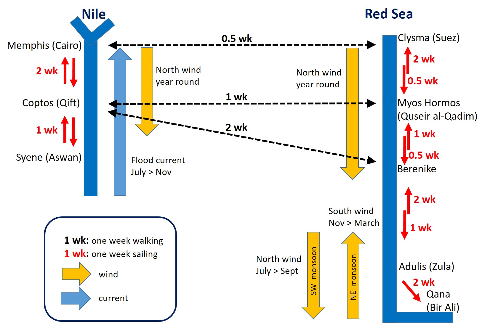
Journey times for northbound and southbound shipping are shown on the sketch. These are of course approximate times without stops at ports. Southbound on the Red Sea is pretty fast with around 50 to 80 nautical miles per day (i.e. 4 to 6.5 knots assuming 12 hours/day sailing time). Northbound on the Red Sea is very slow as sailing is not possible in a straight line and no more than 20 to 25 nautical miles/day can be done (i.e. less than 2 knots assuming 12 hours/day sailing time). These values are confirmed by Pascal Arnaud (2005) who is a Roman historian and a sailor himself[3].
Journey times on land between the Red Sea ports and the Nile are provided also.
As a result, the journey time from Berenike to Memphis was ca 3.5 weeks by the Red Sea via Clysma, and ca 4 weeks by the Nile …
A small difference that may not have been
that important in ancient times
when “time is money” was less important than
“have a safe trip back home” …
Concerning the Indian Ocean crossing, De Romanis (2015) suggests that Adulis was a hub where Red Sea ships met large Indian merchantmen calling at this port after crossing the Indian Ocean in the NE monsoon. This wind sets in during September in the northern part of India (Punjab), November in the southern part (Malabar) and December in Sri Lanka. Ships returning west from Sri Lanka could therefore possibly save time by first sailing north along the Indian coast until reaching the NE monsoon zone, before crossing the Indian Ocean.
Once in the Red Sea, they could transfer their cargo to smaller Red Sea ships at Adulis or sail further north to Berenice thanks to the southern winds blowing until March. These large ships would probably not sail further north to Clysma and Aila, leaving that area to smaller Red Sea ships that are easier to sail in adverse wind conditions. Indian merchantmen would thus overwinter at Adulis or Berenice in order to sail back to India when the SW monsoon arrived in March.
The Red Sea ships would thus sail from Adulis or Berenice to Clysma, where cargo could continue by land, or by water on Trajan’s Canal (also called Necho’s canal, or Darius’ canal). In the latter case, they would have to wait for high water on the Nile, not before July (the Nile flood season is in August-September-October). Hence, they had several months to sail north beating the wind on the Red Sea between Adulis or Berenice and Clysma. Plenty of time… perhaps even too much, as it was much faster to travel by land from Berenice (or Myos Hormos) to the Nile valley.
“Time is money” after all!
Notes
[1] COOPER, J.P., 2011, “No easy option: Nile versus Red Sea in ancient and medieval north-south navigation”. In W.V. Harris & K. Iara (eds), Maritime Technology in the Ancient Economy: Ship Design and Navigation. Journal of Roman Archaeology Supplementary Series 84: 189–210.
This paper cites SIDEBOTHAM, S.E., 1989, “Ports of the Red Sea and the Arabia-India Trade”, in Fahd, T. (ed.), “L’Arabie préislamique et son environment historique et culturel”, (Strasbourg, 1989), (p 195–223).
[2] DE ROMANIS, F., 2015, “Trajan’s Canal and the Logistics of Late Antiquity India Trade”, in V. Christides (a cura di), Interrelations between the Peoples of the Near East and Byzantium in Pre-Islamic Times, Corduba: Oriens Academic-CNERU-DTR, (p 123-135).
[3] ARNAUD, P., 2005, “Les routes de la navigation antique”, éd. Errance.