Why trade?!
In order to provide your country’s consumers with the goods they wish, you need to import some of them and to pay foreign producers for the goods and for their transportation. The required money can be obtained by exporting your own goods and services.
Foreign merchants could export Roman goods as a return cargo when sailing back to foreign countries. The Roman state could provide the ‘service’ of military protection of provinces within the area of “Pax Romana”, receiving a tribute for this service. However, the main Roman export was gold and silver bullion used for payment of imported goods!
How trade?
Trust between buyers and sellers is required, hence regular trading contacts are necessary, and therefore repetition of trade routes. To be ‘professional’, you need to specialise: choose your goods, choose your trade cities and routes, choose your trade contacts[1]. That will be ‘your’ trade network. The nodes of each network may be large inter-regional ports (‘hubs’) or smaller regional, or even local, ports.
Trade hubs
According to Wikipedia, a hub is the central part of a wheel that connects the axle to the wheel itself. Many expressions use the term for a literal or figurative central structure connecting to a periphery. A transport hub is a place where cargo is exchanged from one transport mode to another. With the growth of containerisation, intermodal freight transport has become more efficient.
Today, there are several major nodal points for maritime traffic which are related to the network of main streams of traffic:
- consumer goods transported in containers from China, Korea and Japan to Europe via the Suez Canal and to the US west coast via the Pacific Ocean;
- energy such as oil, Liquid Natural Gas (LNG) transported in bulk from the Middle East, to China, Korea and Japan and many other countries;
- other raw materials such as coal and iron ore are also transported in bulk from Africa, Australia and South America to many countries.
The major nodal points, now called ‘hubs’, are therefore located in Europe (Rotterdam, Hamburg), in USA (Los Angeles, San Francisco, New York, New Orleans), in Asia, (Shanghai, Hong Kong, Busan, Yokohama, Singapore)[2].
Alexandria was the “greatest emporium of the world”, acc. to Strabo (Geogr. 17, 1, 13): Goods were imported from, and exported to, South Arabia, East Africa and India[3], and paid for with gold and silver bullion; they were taxed at 25% by the Roman state, thereby providing a substantial part of its total income:
- Some goods, such as perfumes and dyed silk, were transformed and manufactured in Alexandria, thereby adding great value to the imported goods;
- Goods were exported to Rome and other cities of the empire: not only exotic spices and goods from beyond the Red Sea, but also vast quantities of grain produced in Egypt.
Alexandria was a hub of the Roman economy. Additional nodes of a large-mesh Roman trade network might be located at Gades (Baetica, for garum, salted fish, olive oil) and at Carthago (Proconsular Africa, for wheat and olive oil). This coarse network shows 3 lines converging on Rome. The question is whether finer-mesh networks might be added to the coarse one by including nodal points of smaller importance[4].
Data base analysis
Let’s elaborate on this with an analysis of our database on ancient ports: we know of nearly 6000 ancient coastal settlements, out of which around 2000 are explicitly mentioned as ports by ancient authors:
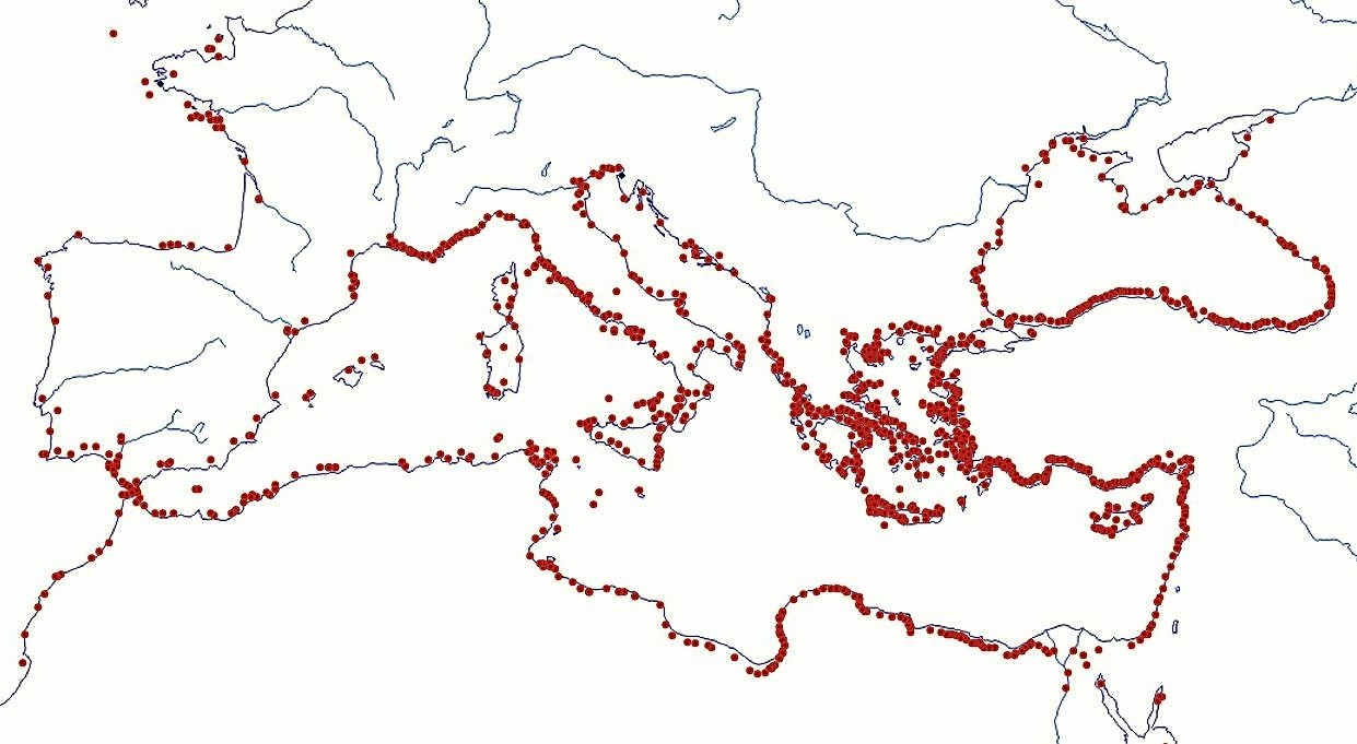
This map has no pretention of precision; it just intends to show concentrations of ports; more accurate locations are available on Google Earth maps shown on: www.AncientPortsAntiques.com
A corpus of 87 ancient authors from 1500 BC to 500 AD has been analysed, searching for the word ‘port’ in the 19th c. French translations available on the web (mainly www.remacle.org), (see Volume II, Citations). Each author is counted only once for each port, even if he mentioned the port several times in several books or chapters.
Obviously, various reasons motivated ancient authors to mention these ports: historical (military, naval), commercial (trade, emporia), geographical (description of land and peoples) or sailors following the coasts. In the picture above, trips like those of Arrian on the Black Sea or the Stadiasmus can nearly be distinguished.
Furthermore, ancient authors may sometimes have been somewhat egocentric when describing only their own part of the world, like Pausanias in Greece, which may have led to ‘zooming’ effects in some areas.
Conversely, some areas were not much mentioned by ancient authors, like Hispania, Lusitania, Gaul, and it cannot be said if that is because there were no ports (which is surely untrue) or because these somewhat remote areas were of lesser interest to ancient Greek and Roman authors. Anyway, a concentration of ports mentioned by ancient authors can be seen around the Aegean Sea.
Further analysis of the data base shows:
Nearly 1000 ports are mentioned by only one ancient author.
Nearly 300 are mentioned by two ancient authors.
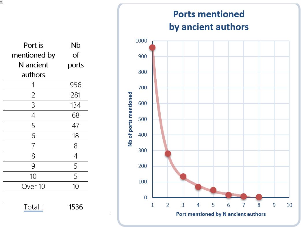
Nearly 100 ports are mentioned by five or more ancient authors. These places are listed below in a clockwise ranking around the Mediterranean, with the number of authors mentioning it in brackets:
- Hibernia (Isle of Ireland) (5)
- Gades (5)
- Carthago Nova (5)
- Massalia (5)
- Monoeci (Monaco) (5)
- Portus Pisanus (6)
- Aithalia (Isle of Elba) (5)
- Portus Augusti Ostiensis (over 10) and Ostia (7)
- Antium (5)
- Caiete (5)
- Misenum (6) and Puteoli (5)
- Rhegium (7)
- Zankle (Messina) (9)
- Syracuse (over 10)
- Crotone (5)
- Lilybaion (5)
- Tarentum (7)
- Hydruntum (Otrante) (6)
- Brindes (9)
- Corcyra (8) and Casiope (5) (Isle of Corfu)
- Glykys Limen (5)
- Nisea (5)
- Kytlene (5)
- Pylos (5)
- Gytheion (7)
- Skandeia (Isle of Kythera) (7)
- Nauplia-Argos (5)
- Lechaion-Corinth (10) and Sicyon (8)
- Kenchreai-Corinth (over 10)
- Salamis (Isle of Salamis) (6)
- Piraeus (over 10)
- Phaleron (7) and Munychia (5)
- Aegina (6)
- Aulis (6), Chalkis (5) and Eretria (5) (Isle of Evia)
- Thasos (Isle of Thasos) (5)
- Abydos (10) and Sestos (6)
- Byzantium (6)
- Portus Symbolorum (Crimea) (5)
- Sindicos (Anapa) (5)
- Sinop (6) and Armene (5)
- Calpe (5)
- Cyzikos (5)
- Sigeion (5)
- Delos (Isle of Delos) (10)
- Naxos (Isle of Naxos) (5)
- Tenedos (Isle of Tenedos) (8) and Troy (6)
- Mytilene (Isle of Lesbos) (over 10)
- Phokeia (6)
- Elaia (5)
- Chios (Isle of Chios) (over 10)
- Ephesus (10)
- Pythagoreion (isle of Samos) (over 10)
- Miletos (9)
- Kos (Isle of Kos) (5)
- Knidos (7)
- Rhodes (over 10)
- Kaunos (5)
- Patara (8)
- Korikos (Kizkalesi) (5)
- Phaselis (5)
- Paphos (Isle of Cyprus) (5)
- Salamis (Isle ofCyprus) (5)
- Sidon (6)
- Tyr (6)
- Alexandria (over 10)
- Paretonius (5),
- Menelaus (5),
- Neapolis-Leptis (5)
- Cercenna (6)
- Carthago (8) and Utica (5)
- Melite (Isle of Malta) (6)
The listed places are shown on the map below (green dots) together with the four ‘main hubs’ (black dots). The listed places are fairly concentrated in an area between Rome and Rhodes covering the southern part of Italy, Greece, the Aegean Sea and Asia Minor. It cannot be denied that this area was the most active area both for trade and for naval operations during a millennium from the 5th c. BC to the 5th c. AD.
Note that no time frame was defined, hence Greek hubs of the 5th c. BC are mixed with imperial Roman hubs of the 1st c. AD. Had we restricted the time frame to e.g. the 6th to 4th c. BC, we would have seen Piraeus (over 10), Emporion (Spain) (4), and Naucratis (Egypt) (1) as main hubs. Had we taken the 3rd and 2nd c. BC, we would have mentioned Delos (10).
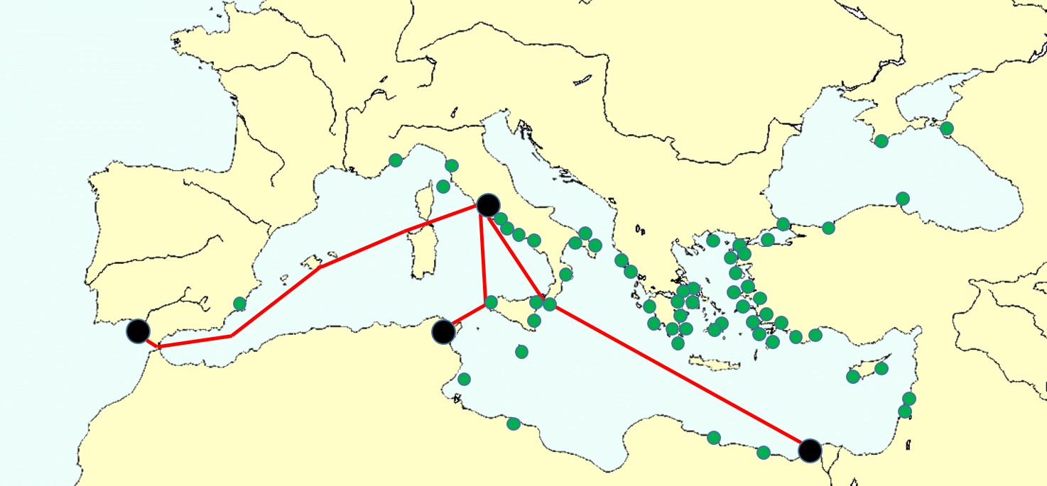
It must be admitted that the above approach based on the number of ancient authors mentioning places does not show the trade networks we would expect intuitively because major cities are missing (Tarraco, Narbo, places on the Adriatic, on the Black Sea, in northern Africa).
Foundation of coastal settlements
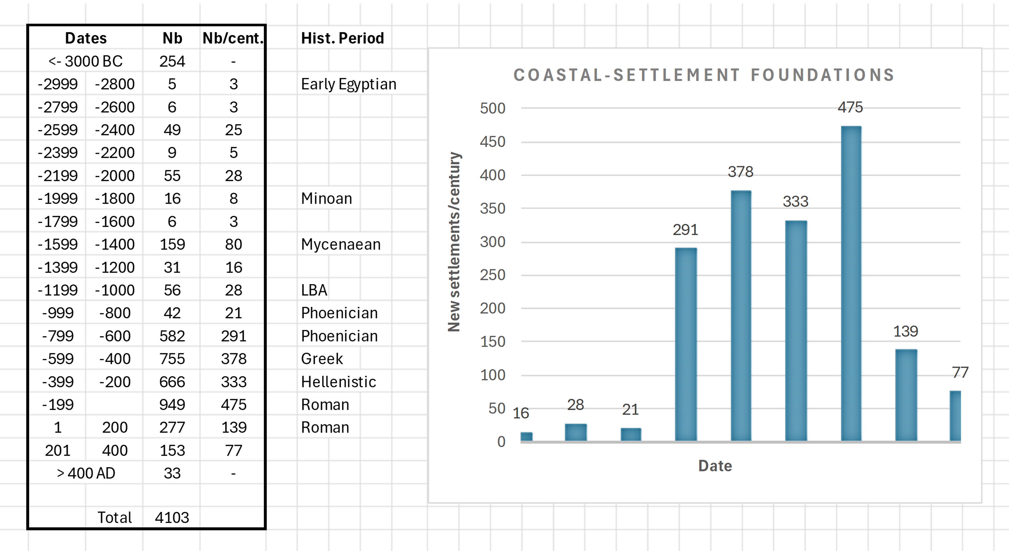
Out of nearly 6000 coastal settlements, around 4000 places were listed with an approximate foundation date (see Volume I, The Catalogue). Let’s consider the time frame from 3000 BC to 400 AD and subdivide it in periods of 200 years. The number of new settlements founded in each period of 200 years is taken from the data base and divided by 2 in order to obtain the number of new settlements per century.
The resulting table below shows that the Phoenician-Greek-Hellenistic-Roman period yields 300 to 500 new settlements/century. A sudden increase of this number starts around 800 BC when Phoenician, Greek and Hellenistic civilisations emerged. A decline is seen in the Roman imperial period which shows that less new places were created, possibly because ‘good places’ were already in use and further developed by the Romans.
Notes
[1] ARNAUD, P., 2012, “La mer, vecteur des mobilités grecques”, in “Mobilités grecques”, Capdetrey & Zurbach (edt.), Scripta Antiqua 46,Ausonius, Bordeaux, (p 89-135).
[2] DUCRUET, C., 2015, “Inside the pond: an analysis of Northeast Asia’s long-term maritime dynamics”, International Journal of Maritime Affairs and Fisheries, Korea Maritime Institute, 2015, 7 (2), pp.25-40.
[3] ARNAUD, P., 2015c, “ La batellerie de fret nilotique d’après la documentation papyrologique (300 avant J.-C.-400 après J.-C.) ”, in La batellerie égyptienne, Archéologie, histoire, ethnographie, éd. P. Pomey, Centre d’Etudes Alexandrines, 34 – 2015: Kerkouros-type ships were sailing and rowing southward on the Nile in winter time, at least during the Hellenistic period.
[4] BRAUDEL, F., 1949, “La Méditerranée et le monde méditerranéen à l’époque de Philippe II”, éd. Armand Colin, Paris, (533 p) : he distinguishes various basins: “La Méditerranée n’est pas une mer, mais une succession de plaines liquides communiquant entre elles par des portes plus ou moins larges.” Each basin is the result of human cultures superimposed upon physical constraints, with continuous changes always going on.
See also: ARNAUD, P., 2005, “Les routes de la navigation antique”, éd. Errance, Paris, (248 p),
and: STONE, D., 2014, “Africa in the Roman Empire: Connectivity, the Economy and Artificial Port Structures”, American Journal of Archaeology, 118(4), (p 565-600).