Our aim in this section is to compute travel times between various ancient ports (hubs discussed in the section on “Ancient maritime trade”) and to compare different alternative routes between two ports, e.g. Alexandria and Portus, compare both ways to and from each place, and compare seasonal influences.
Ancient sea routes have been described by several ancient authors such as Strabo and Pliny, and by an anonymous author who wrote a document known as the “Stadiasmus”. Pascal Arnaud produced a monumental work in 2005 summarising these ancient navigation routes[1]. Apart from a collection of 127 Mediterranean navigation routes, he was able to define the main units of distance. This is not as trivial as it would appear at first sight, as each distance at sea was defined by sailing days and was converted by the ancient scholars into distances in stadia[2]. Pascal Arnaud was able to distinguish the following basic units of distance: 1000 stadia, 700, 600 and 500 stadia. He was able to correlate these distances with travel times as follows:
- one-day + one-night sailing (24 h) yields a 1000 stades travelled distance,
- half a day & night (12 h) yields 500 stades,
- one daylight sailing, “daytime” (15-17 h) yields 600-700 stades.
With one stadium equalling 1/10th of a nautical mile, the average ship velocity therefore was around 4 nautical miles per hour, i.e. 4 knots[3]. It may be argued that this definition of distances based on travel times depends on the meteorological conditions (winds and waves, assuming that currents are usually negligible in the Med). This is true, but ancient sailors had no accurate instrumentation for measuring positions expressed in latitudes and longitudes[4]. Ancient authors reporting distances at sea obviously took the meteorological conditions of each trip into account and provided some kind of averaged value. We may thus consider at this point that we have a reliable data set for distances between ports reported by ancient authors. This data set was carefully analysed and validated by Pascal Arnaud.
Let’s now turn to a computational model of these Mediterranean navigation routes. A major attempt was conducted in the ORBIS Project by Stanford University (http://orbis.stanford.edu/# ) in 2011-2014. This model is a superb tool that seems to be still operational online, but:
- it works with a coarse 5 x 5° grid for wind stats,
- the choice of the “fastest” track is not explained (black box effect),
- it is “relying on a modest number of segmented routes” and “roughly approximates the preferred routes of sailors in the Roman period” and it is therefore not open to choosing other routes.
Based on the ORBIS approach, I decided to build my own model based on a 1 x 1° grid for wind stats, and allowing any route to be chosen on that grid. This approach is clearly using averaged values for winds (based on long term statistics) and averaged values of ship speeds for each relative wind direction, including parameters such as high waves and low visibility. Hence, computed travel times are also averaged values.
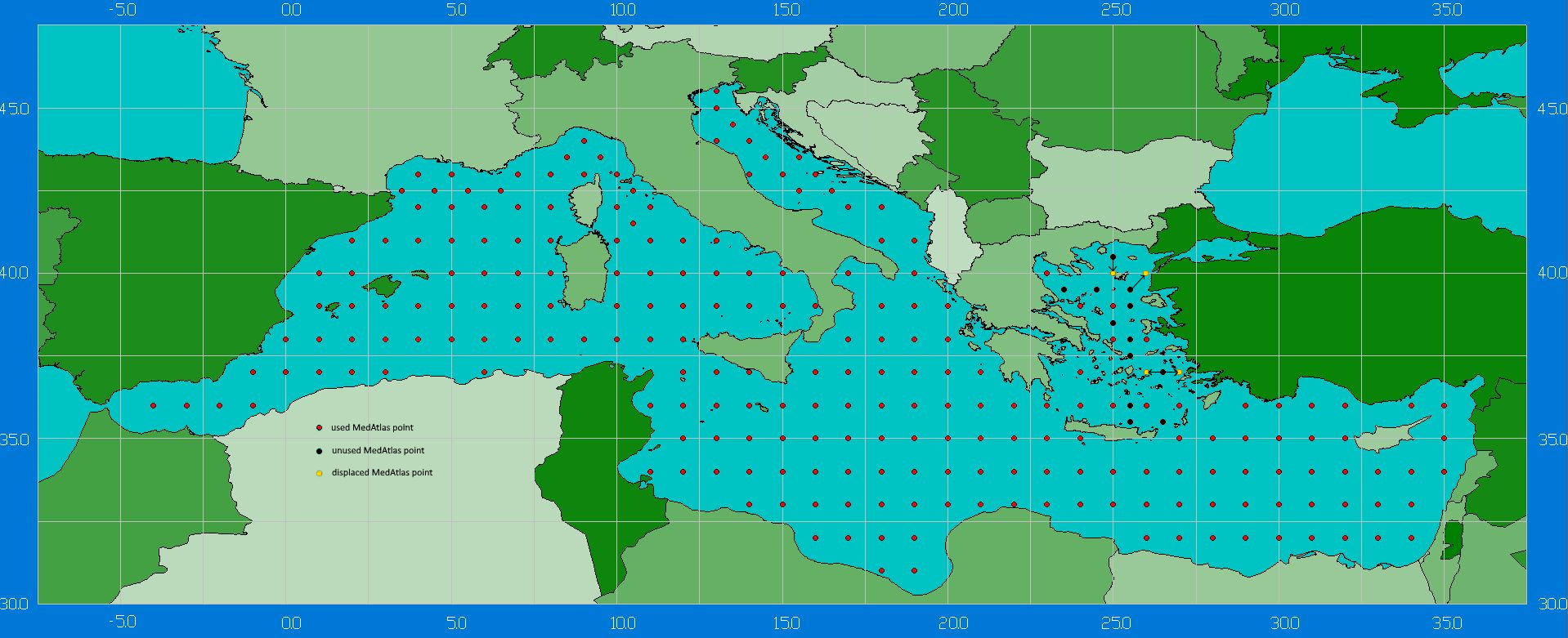
In a first stage, the detailed MedAtlas[5] data was taken over for each point on a 1 x 1° grid for the whole area of the eastern and central Mediterranean Sea, say from Tyre to Portus. This encompasses 147 grid points with wind data for annual and four seasonal conditions.
Secondly, the ship model was taken over from Arcenas[6]. This ship model is a ship-speed rose providing a ‘Velocity made good’ (Vmg) for each relative wind direction. Vmg is the resulting velocity of the ship in the desired direction, which may result from various sailing techniques such as tacking and gybing, including the ship’s leeway.
Third, the wind statistics were combined with the ship model to provide resulting ship speeds for each heading at each grid point.
Fourth, this result is used in a navigation model, where a track passing through a number of grid points is chosen from one place to another (e.g. harbour or promontory). The distance between each point is computed by means of spherical trigonometry and the travel time is deduced from the ship speeds at each grid point.
In order to validate this ‘MedNav’ model, around 40 trips which had been identified by Pascal Arnaud were used. The result is shown below in a comparison of computed travel times with travel times reported in ancient texts.
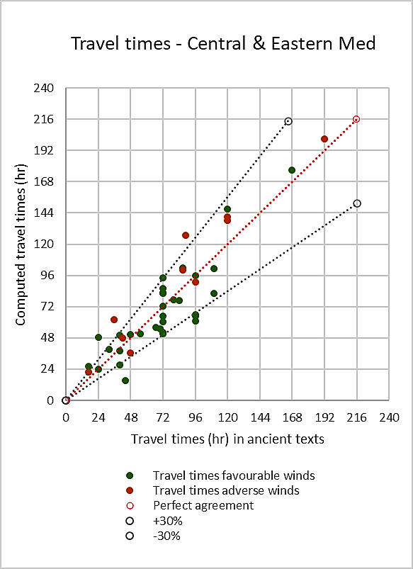
The red dotted line is the line of perfect agreement when computed and reported travel times are exactly equal. Both grey dotted lines show +30% and -30% values and it can be seen that most of the points lay within the +/-30% range (that is nearly a factor one in two). It may be noted here that this range corresponds to the meteorological uncertainties you might take into account when planning any trip at sea with a sailing boat.
Globally, the data points show a nice agreement with a correlation coefficient of 0.91. This result also shows that the Arcenas ship is quite good.
A distinction was made between trips with favourable winds and trips with adverse winds (e.g. travelling from east to west in the eastern Med or from south to north in the Aegean). This result shows that little impact of wind conditions is felt and proves that ancient authors have taken this cleverly into account in their distance estimates.
We are now ready to go one step further in using the MedNav model for computing the famous Alexandria-Portus routes, including seasonal effects.
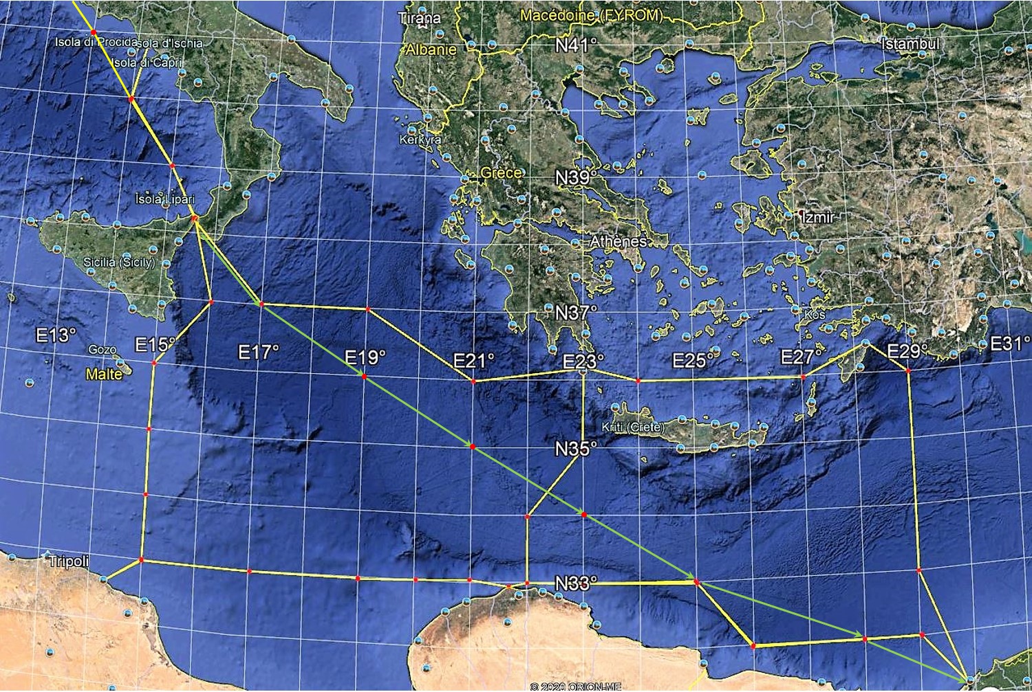
The route from Portus to Alexandria enjoys favourable NW winds all along. From Portus, we sail down to the strait of Messina (ancient Zankle) and from there to Alexandria in a direct SE track (green arrowed line in figure above). This trip reputedly takes one to two weeks. This direct track, as the crow flies, is 1084 nautical miles (2007 km) and is sailed at an average speed of 4.5 knots in 244 sailing hours (ca. 10 days). Taking the same way back would mean beating the adverse wind all the way and it would be very uncomfortable. We have therefore been looking for other routes:
- Alexandria-Rhodos-Kythera-Zankle-Portus, the north route via the southern Aegean and Ionian seas.
- Alexandria-Paphos-Rhodos-Kythera-Zankle-Portus, the same as above, but via Cyprus.
- Alexandria-Phycus-Leptis Magna-Zankle-Portus, the south route via Cyrenaica.
The computations show that the fastest route is the north route via Rhodos, with 452 sailing hours (2.8 kt average speed). The next fastest is the uncomfortable direct track beating the wind, with 462 hr (2.4 kt average speed). Another route leads to Rhodos via Paphos (Cyprus), but is slower with 482 hr. The south route requires beating the wind between Alexandria and Phycus (Cyrenaica) and yields 490 hr. Summarising, it may be stated that the trip from Alexandria to Portus takes 450 to 500 sailing hours depending on the chosen route. That is around 20 sailing days, plus or minus one day, and twice the time required to sail with favourable winds from Portus to Alexandria.
It seems that these results nicely fit the general feeling of scholars interested in this subject, who agree that ancient vessels averaged between 4 and 6 knots with favourable winds, and less than 2 knots to 2.5 knots with unfavourable winds[7].
With this renewed trust in our model, we can investigate further and check the seasonal influence. Let’s take the same trip between Alexandria and Portus, both ways, and compute the travel times in each of the four seasons.
| Route | Spring | Summer | Fall | Winter |
| Portus > Alex direct track | 266 | 244 | 267 | 253 |
| Alex > Rhodos > Portus | 402 | 452 | 381 | 360 |
| Alex > Leptis Magna > Portus | 440 | 490 | 420 | 435 |
On the way to Alexandria, seasons do not matter much as the travel time is around 240-270 hours (10-11 days). However, on the way to Portus, seasons do matter a lot. Summer is obviously the worst period to sail in this direction, as the trips in fall and winter are clearly faster. Note that the south route via Leptis Magna is always somewhat slower than the north route via Rhodos, but this does not prevent you from doing so if you have some lucrative business there.
It must have been quite a temptation to sail in wintertime (during “mare clausum”), but the risk of an unexpected storm was much higher (see Luke’s final trip to Rome, Luke’s Acts, 27, 11).
Another recurring question is what the fastest route from Alexandria to Rhodes in summer is, with north-western etesian winds. The direct route from Alexandria to Rhodes is around 350 nautical miles; the next shortest is via Paphos (Cyprus), with 500 n. miles; the next is via Tyre (Lebanon) and Paphos with 750 n. miles and the longest is via Tyre, Seleucia Pieria and along the southern Turkish coast, with 800 n. miles. The travel times are respectively 120 h, 150 h, 225 h and 230 h. The direct route is fastest but requires quite some struggle with the wind at close reach. The trip via Paphos will be fast to Paphos and rough after that. Both trips along the Levantine coast are much longer and are justified only if particular business can be done there during the trip.
We may thus confirm that two return trips between Alexandria and Portus could be undertaken each year as follows:
- Alexandria to Portus in spring, just after the Egyptian harvest, arriving in Portus in May-June (note the ‘Alexandrian ships’ were overwintering in Alexandria in order to be ready for departure in spring as soon as harvesting was conducted),
- Portus to Alexandria in summer, arriving in Alexandria in July-August,
- Alexandria to Portus in fall, arriving in Portus in September-October,
- Portus to Alexandria in fall, arriving in Alexandria by the end of October.
Notes
[1] ARNAUD, P., 2005, “Les routes de la navigation antique”, edt. Errance, (248 p) & ARNAUD, P., 2012, “La mer, vecteur des mobilités grecques”, in “Mobilités grecques”, Capdetrey & Zurbach (edt.), Scripta Antiqua 46,Ausonius, Bordeaux, (p 89-135).
Note that Pascal Arnaud not only is a famous professor in Roman History, but also an experienced sailor who has been sailing the Med himself for decades.
[2] One Roman stadium is 185 m long, which equals 1/10th of a modern nautical mile of 1852 m. However, ancient authors often used other definitions of the stadium (Greek, Egyptian, etc. which are somewhat different (say from 150 to 200 m).
[3] WHITEWRIGHT, J., 2011, “The Potential Performance of Ancient Mediterranean Sailing Rigs”, The International Journal of Nautical Archaeology (2011), 40.1: 2–17. According to ancient reports, ancient ships sailed at 1 to 2 knots in adverse wind conditions and 4 to 6 knots with favourable winds.
[4] This concept was introduced by Ptolemy in the 2nd c. AD, see also sections on “Ancient maps” and “Measuring latitudes”.
[5] MEDATLAS, 2004, “Wind and Wave Atlas of the Mediterranean Sea”, Scientific Report RTP10.10, Western European Armaments Organisation.
[6] ARCENAS, S., 2015, “ORBIS and the Sea: a model for maritime transportation under the Roman Empire”, ORBIS Project, Stanford Univ., (6 p), (http://orbis.stanford.edu/# ). We chose his “fast ship”.
[7] CASSON, L., 1995, “Ships and seamanship in the ancient world”, Johns Hopkins University Press, (p 282-291).
GAL, D., SAARONI, H., CVIKEL, D., 2021, “A new method for examining maritime mobility of direct crossings with contrary prevailing winds in the Mediterranean during antiquity”, Journal of Archaeological Science, 129, (16 p).
GAL, D., SAARONI, H., CVIKEL, D., 2022, “Mappings of Potential Sailing Mobility in the Mediterranean During Antiquity”, Journal of Archaeological Method and Theory, Springer, (52 p).
They use a more sophisticated methodology based on weather-routing software and a higher spatio-temporal resolution. They also include a human factor. Their results show a bit slower navigation, but their ship model is based on the smaller Ma’agan Mikhael II ship replica described by Palzur, 2021.
GAL, D., SAARONI, H., CVIKEL, D., 2023, “Windward Sailing in Antiquity: The Elephant in the Room”, IJNA International Journal of Nautical Archaeology, DOI: 10.1080/10572414.2023.2186688
PALZUR, Y. & CVIKEL, D., 2021, “Sailing Ma‘agan Mikhael II”, Archaeonautica[Online], 21 | 2021, (p 277-282).