As 75-80% of tsunamis are related to a submarine earthquake, let’s have a look at the latter first.
Earthquakes
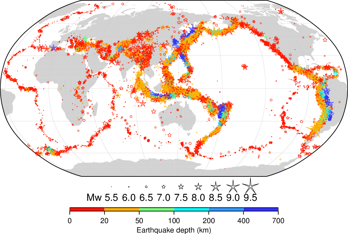
Earthquakes and volcano eruptions usually occur along faults separating tectonic plates moving with respect to each other.
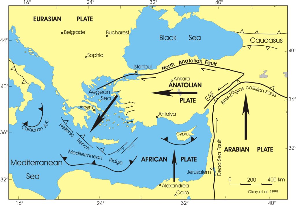
The African plate is moving northwards under the Anatolian plate; The Arabian plate is moving northwards inducing a rotation of the Anatolian and Aegean plates; The boundary between the African and the Arabian plates is on the Dead Sea Fault, Jordan valley and Beqaa valley.
The North Anatolian Fault is passing near Istanbul and a volcanic arc follows the isles of Aegina, Milos, Santorini, Nysiros/Gyali/Kos; In this process, the Aegean plate is sucked downwards, inducing subsidence of islands.
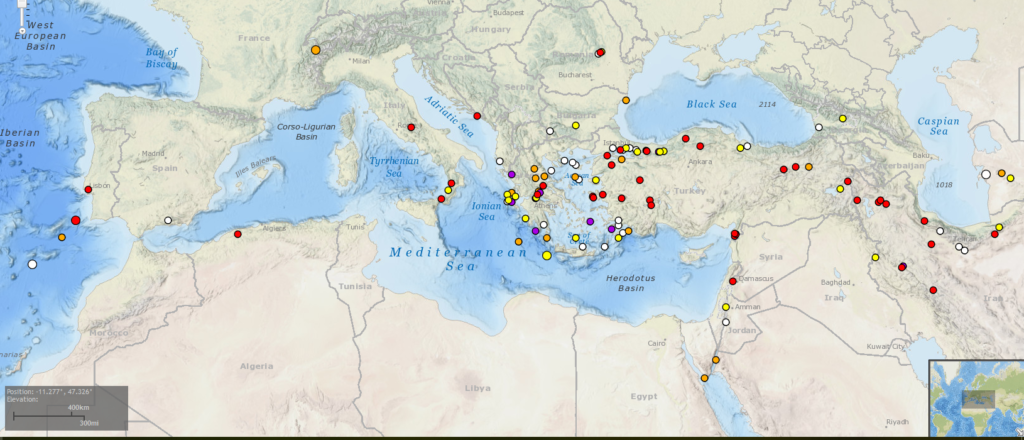
Most of them are located along the faults mentioned in the previous figure.
Measuring the ‘size’ of an earthquake is not a simple matter. One can describe the damage that occurred at a certain location and thus define a local ‘earthquake intensity‘ (Mercalli, EMS-98 and others, usually ranging from 1 to 12). However, this may seem subjective and is location-dependent. Therefore, more scientific ‘earthquake magnitudes‘ were defined (Richter and others) that are based on seismographic measurements and reflect the size of the earthquake at its epicentre.
Tsunamis
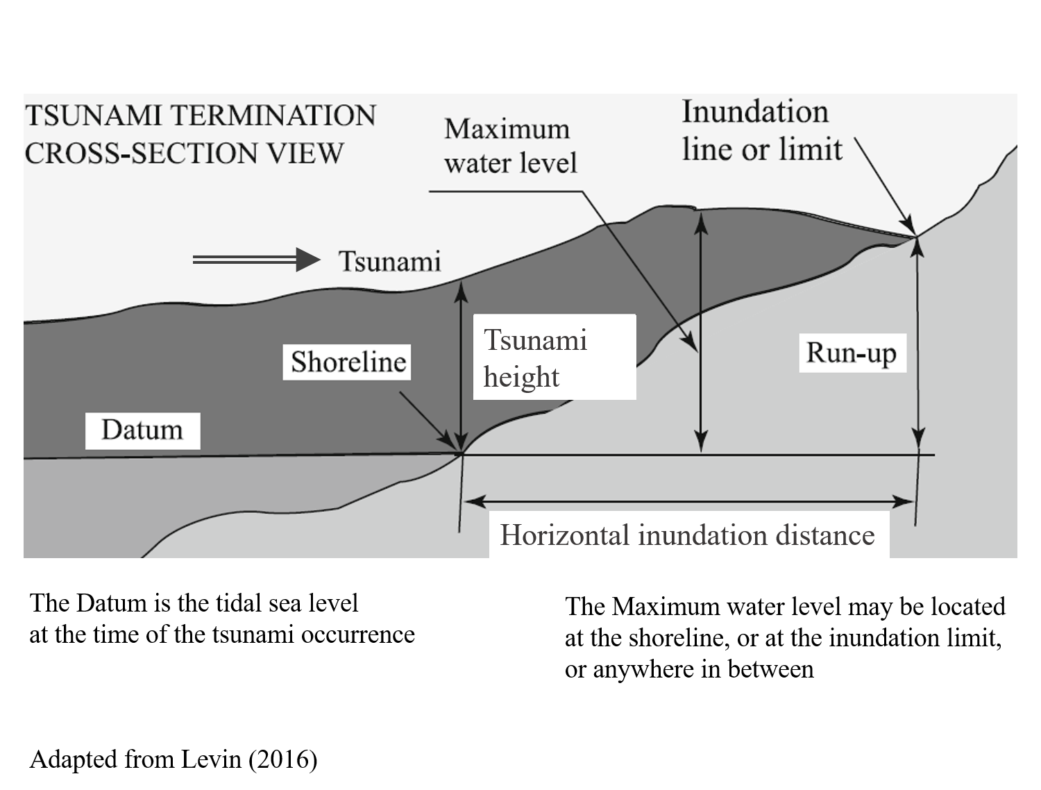
The size of a tsunami is also hard to define. It can be described as the horizontal inundation distance of inland flooding, or as the vertical run-up on a sloping shoreline, and/or as the maximum rise of the water level above the normal tidal level at the time of occurence of the tsunami (called “tsunami height” H), and/or as the water depth (and flow velocity) of the flow flooding the shoreline. Soloviev (1974) proposed a ‘Soloviev-Imamura tsunami intensity scale‘ ‘I’ based on the tsunami height, averaged along the nearest coastline (Hav): for Hav = 2.8 m, I = 2, and for Hav = 5.5 m, I = 3.
More recently, a new Integrated Tsunami Intensity Scale (ITIS-2012) with a scale ranging from 1 to 12, was proposed by Lekkas et alii (2013)[00].
Attention has been focused on this natural phenomenon in recent times, and has been well known by the Japanese over the past millennia, reason why we use the Japanese word ‘tsunami’ to designate a group of a few waves, that travels on the sea surface and reaches the coast inducing more or less damage and casualties. A tsunami is not a storm consisting of many high waves. A tsunami might be compared to a tidal bore, but its generation is not due to the tide (triggered by moon and sun).
A tsunami is a large-scale, short-duration disturbance of the free water surface usually generated by crustal movements of the earth. Such movements can be generated by earthquakes and by volcanic eruptions inducing submarine landslides. This was intuitively understood by Thucydides (History of the Peloponnesian war, 3, 89). Other generating factors can be coastal landslides from the shore into the sea (ca. 10% of tsunamis), submarine volcano eruptions or explosions (ca. 5% of tsunamis), high-density pyroclastic flows, glacier calvings, and even meteorite impacts[0]. Note that an earthquake does not generate a large tsunami by itself because the vibrations of the earth are of a frequency (say 0.1 Hz) unable to move a large body of water like a sea, but it can generate an onshore or a submarine vertical landslide, which may generate a tsunami if it is large enough and sudden enough. For this reason, the formal relationship between the intensity of a tsunami and the intensity of its generating earthquake is rather loose, i.e. a strong earthquake may generate only a small tsunami and vice-versa.
You can make your own small-scale modelling just by throwing a stone in still water!
From its area of generation, a tsunami propagates like a sea wave on the sea surface. However, its speed is much larger (say 500 to 1000 km/h, e.g., if generated near Crete, it may reach any eastern-Med coast in less than one or two hours). On deep water, the tsunami may have a fairly small height (say less than one meter), but when it reaches shallow waters (say less than 1000 m), the wave will gradually steepen and its height will increase. By a very fortunate coincidence, a Belgian yacht, the Mercator, was anchored on 14 m water depth at 1.6 km offshore Phuket during the 2004 Indian Ocean tsunami, and they registered the following water-level variation:
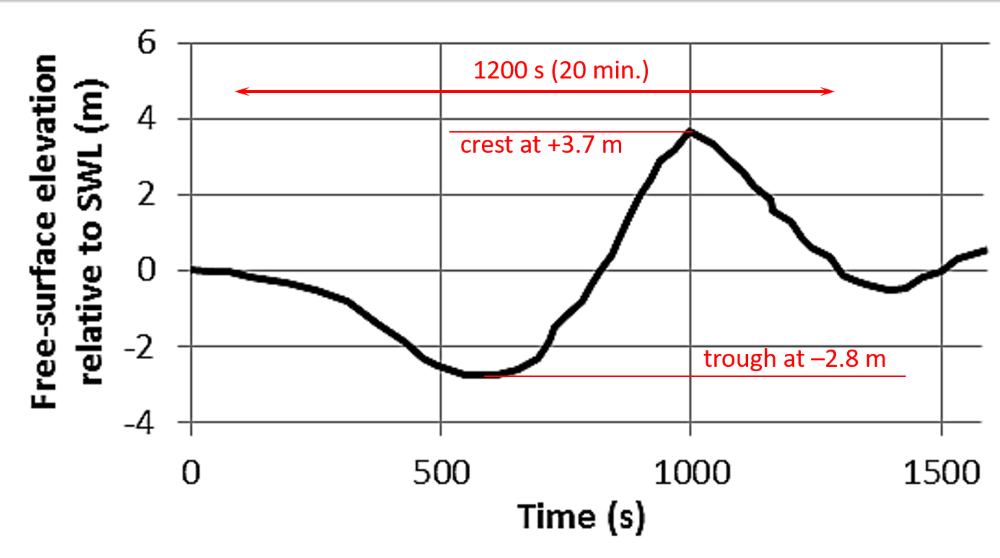
(adapted from Chandler, et al, 2016).
If you follow the graph from left to right, you see a 2.8 m deep trough coming first, followed by a 3.7 m crest, yielding a 6.5 m wave height. The total duration of the wave passing by was around 1200 s, or 20 minutes, and the rise from -2.8 to +3.7 m took only around 6 minutes and must have been quite impressive on board the yacht. This graph also shows that the shoaling tsunami wave becomes ‘non-linear’, featuring a narrower crest and a wider trough, deviating from the ‘linear’ sinusoidal shape.
Like any wave, a tsunami will break when it reaches relatively shallow waters (local wave height/local water depth = 0.5 to 1). Hydraulic research on scale models has shown that the tsunami wave front splits into a few short waves that are amplified by shoaling just before breaking (factors of 3 to 5 times the offshore wave height have been recorded). You might imagine that due to friction on the seabed, the bottom of the wave will travel slower than the top of the wave, thus leading to a ‘spilling‘ (or ‘plunging’) of the top of the wave over the bottom side of the wave. The problem with a tsunami is that its wavelength on deep water (order of 100 km) is much larger than that of a normal wave (order of 100 m), thus containing much more energy. Therefore, the volume of water involved in this spilling process is huge, resulting in a high-speed horizontal flow of water on the beach and adjacent coastal area (say 5-10 m/s, and more, video). This incoming wave might be called a ‘tsunami bore’, similarly to a tidal bore (See the most impressive Qiantang tidal bore in Hangzhou Bay (China) featuring a 5-6 meters sudden rise of water level). The height of this water flow is usually limited to a few meters (6 m at Tohoku, 2011), but it can reach a considerable run-up height on an inland hill-slope (up to 40 m at Tohoku, 2011) or propagate over several kilometres inland on horizontal terrain (10 km at Tohoku, 2011).
Obviously, this huge volume of water must flow back to the sea, inducing further damage, depending on the inland slope.
Moreover, the flooding may consist of several waves within say one hour (further reading on Wikipedia).
In the most dramatic historical events, the effects of an earthquake were combined with those of a tsunami, e.g., a coastal area was subjected to subsidence (or uplift) and to flooding by a tsunami generated elsewhere by the same earthquake. This probably happened on July 21, 365 when Crete literally tilted (9 m uplift on the southwestern side and 4 m subsidence on the northeastern side) with effects felt all over the eastern Mediterranean Sea.
The most (in)famous ancient tsunamis can be listed shortly as follows (a more complete list is presented further below):
- ca. 1600 BC during the Thera (Santorini) volcanic eruption, inducing a tsunami that partly destroyed the Knossos Minoan civilisation,
- 1365 BC at Ugarit, mentioned in an Amarna letter,
- 525 BC at Tyre and Sidon, mentioned by Strabo,
- 479 BC at Potidaia, described by Herodotus,
- 426 BC at Orobiae (north Euboea), mentioned by Thucydides,
- 373 BC at Helike (northern Peloponnesus), when the city disappeared,
- 227 BC at Rhodes, when the Colossus collapsed,
- 92 BC large tsunami on the Levantine coast,
- 79 AD initiated by the Vesuvius eruption near Pompei,
- 365 AD initiated on western Crete but felt from the Levant to Sicily,
- 458 AD at Antioch,
- 551 AD on the Levantine coast, one of the largest ancient earthquakes,
- 747 AD, large earthquake in Galilea and the Beqaa valley,
- 854 AD large earthquake in lake Tiberias
- 881 AD initiated on the Levantine coast but felt from the Levant to Andalucia,
- 991, 1002 or 1003, 1089, 1157, 1202,
- 1303 initiated near Rhodes but felt from Akko to Tunis and Istanbul,
- 1408 around Lattakia,
- and others after 1500.
At least 400 earthquakes and/or tsunamis occurred in the Mediterranean area between 500 BC and 1500 AD, i.e., up to 20 tsunamis/century, mainly in the eastern Mediterranean Sea.
Sedimentological impact of tsunamis
“… to simply identify a palaeotsunami in the geological record is by no means simple. Over the past decade or more, geologists have carefully constructed a proxy toolkit for identifying palaeotsunamis.”[1] This sentence implies that hydrodynamics of tsunamis is a complex field and only few mathematical formulations have been published[2]. The study of movement of materials under the effect of a tsunami is of an even higher level of complexity and must therefore be roughly schematised.
Without going into details, it should be kept in mind that a tsunami consists of a small number of long waves out of which the second is often the highest. Quite differently, a storm, defined by a “significant wave height” Hs, consists of thousands of short waves out of which only one maximum wave is moving more materials than any other wave (it is usually accepted that Hmax = 2 Hs).
We may distinguish the impact of tsunamis on rock boulders resting near the shore and on various types of offshore marine deposits[3].
Boulders
Several formulations have been proposed to compute the storm-wave height and tsunami height required to move a given size of boulder, but results show discrepancies[4] which are mainly due to erroneous schematisations of the tsunami hydrodynamics[5].
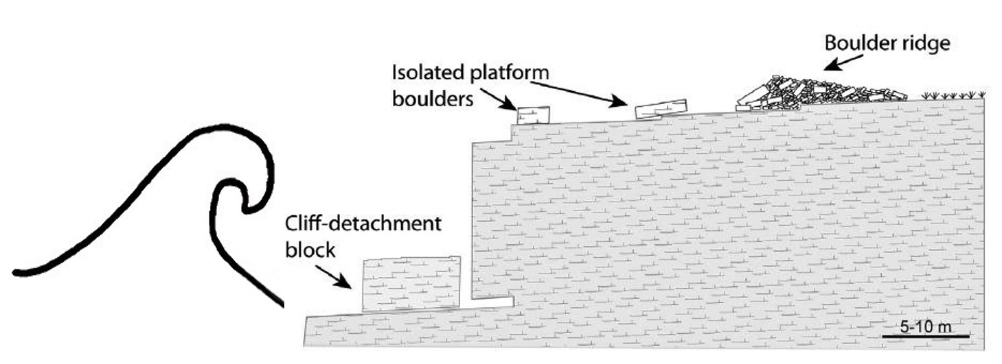
On rocky coasts, we may distinguish small boulders and large boulders.
Small boulders may be moved by large storm-waves, if such waves can reach the location where boulders are resting on the coastline. The largest significant wave heights in the Mediterranean are around Hs = 10 m for a one-hundred-year storm on the coasts of northern Algeria-Tunisia, Cyrenaica and the Levant (see section on design waves). The, for coastal engineers, famous Hudson equation shows that the largest boulders that such a storm might move do not exceed 50 tons. This involves a flow velocity in the order of 10-12 m/s. Hence, in these regions, all boulders smaller than 50 ton might be moved by large storms as well as by tsunamis, but larger boulders can be moved only by tsunamis.
The travelling distance of boulders obviously depends on the tsunami size and on the boulder size, and large boulders have been seen moving over tens of meters on a horizontal surface, or several meters in a vertical movement, e.g., from the waterline to the top of a small cliff[6].
As the hydrodynamics involved are complex, further study of the movement of boulders due to storm waves and to tsunamis must be performed on small-scale models[7], in addition to computations with mathematical models[8].
Marine deposits
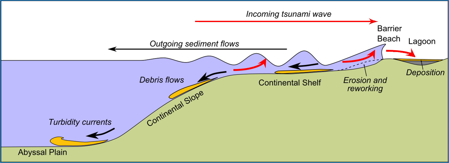
A tsunami wave starts to disturb the seabed as from a long distance of the shore, where the water depth is many tens of meters. At such a water depth, the seabed often consists of very fine sediment like silt and marine mud. While disturbing seabed materials, the tsunami bore becomes turbid, bringing large quantities of fine offshore sediment to the shore. A similar picture occurs when the tsunami is nearing a sandy coast where large volumes of fine dune-sand may be picked up by the bore and transported further inland. If the hinterland is a flat plain, this sediment is thus deposited inland in a layer with decreasing thickness of a few decimetres near the coast to a few millimetres at several kilometres inland. Moreover, the grain size in a vertical section of the deposit is fining upwards[9]. Subsequently to the massive inflow of water, a strong backwash is unavoidable, taking deposited sediment and possibly some terrestrial material back to the sea. It is obviously difficult to predict the result …
Similar deposits may also occur in quiescent coastal lagoons where marine sediment, marine microfauna (foraminifera tests, ostracods, diatoms) and marine macrofauna (bivalve shells) brought by a tsunami may be deposited on top of lagoonal sediment which usually contains brackish-water fauna. However, such deposits may also be due to a super-storm that might have broken through the coastal barrier islands locally, generating a wash-over fan[10].
It might be reminded here that a super-storm on a sandy coast, with say a Hs = 10 m wave height, will show wave breaking at ca. 20 m water depth. That is well offshore the coast, but such a storm will nevertheless induce severe erosion of the seabed and coastline. However, damage induced by a tsunami would be much larger.
It is even more difficult to distinguish between autochthonous and allochthonous deposits in the case of estuaries where river sediment due to river floods is mixed up with marine sediment due to storms, and possibly to tsunamis[11].
In case of uncertainty about the origin of some ancient coastal sediment layers, we like to speak of a “high-energy event”.
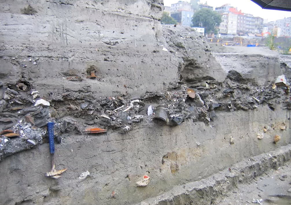
(photo: D. Perincek, 2010)
References
[00] LEKKAS, E., ANDREADAKIS, E., KOSTAKI, I., KAPOURANI, E., 2012, “A Proposal for a New Integrated Tsunami Intensity Scale (ITIS-2012)”, Bulletin of the Seismological Society of America, Vol. 103, No. 2B, (p 1493–1502).
[0] DE LANGE, G., et al., 2011, “Executive Summary”, in “Marine geo-hazards in the Mediterranean”, CIESM Workshop, Nicosia, 2 – 5 February 2011, (p 7–20).
[1] GOFF, J., et al., 2012, “Progress in palaeotsunami research”, Sedimentary Geology, 243–244, (p 70–88).
[2] LEVIN, B., & NOSOV, M., 2014, “Physics of Tsunamis”, Springer, (399 p).
Physical modelling:
CHANDLER, I., et al., 2016, “Understanding wave generation in pneumatic tsunami simulators”, Proceedings of the 6th International Conference on the Application of Physical Modelling in Coastal and Port Engineering and Science (Coastlab16), Ottawa, Canada, May 10-13, 2016
MATSUYAMA, M., et al., 2007, “A study of tsunami wave fission in an undistorted experiment”, Pure Appl. Geophys. 164(2–3), (p 617-631).
YOSHII, T., TANAKA, S., MATSUYAMA, M., 2017, “Tsunami deposits in a super-large wave flume”, Marine Geology 391, (p 98-107).
YOSHII, T., TANAKA, S., MATSUYAMA, M., 2018, “Tsunami inundation, sediment transport, and deposition process of tsunami deposits on coastal lowland inferred from the Tsunami Sand Transport Laboratory Experiment (TSTLE)”, Marine Geology 400, (p 107-118).
Numerical modelling:
WEI, GE, et al., 1995, “A fully nonlinear Boussinesq model for surface
waves. Part 1. Highly nonlinear unsteady waves”, Journal of Fluid Mechanics, July 1995, vol. 294, (p 71-92).
FENGYAN SHI, et al., 2012, “A high-order adaptive time-stepping TVD solver for Boussinesq modeling of breaking waves and coastal inundation”, Elseviers, Ocean Modelling, Vol. 43-44, (p 36-51). FUNWAVE-TVD.
GRILLI, S., et al., 2012, “Numerical modeling of coastal tsunami impact dissipation and impact”, Proceedings of the Coastal Engineering Conference, 33.
[3] MINAMIDATE, K. & GOTO, K., 2024, ” Unveiling the history and nature of paleostorms in the Holocene”, Earth-Science Reviews 253 (2024) 104774, (32 p).
See also: https://en.wikipedia.org/wiki/Tsunami_deposit
[4] PISCITELLI, A., et al., 2016, “Numerical approach to the study of coastal boulders: The case of Martigues, Marseille, France”, Quaternary International, Volume 439, Part A, (p 52-64).
[5] COX, R., 2020, “Systematic Review Shows That Work Done by Storm Waves Can Be Misinterpreted as Tsunami-Related Because Commonly Used Hydrodynamic Equations Are Flawed”, Front. Mar. Sci., 7:4, (18 p).
[6] MAOUCHE, S., et al., 2009, “Large boulder accumulation on the Algerian coast evidence tsunami events in the western Mediterranean”, Marine Geology, 262 (p 96–104).
[7] LIU, H, & SATO, S., 2014, “An experimental study on the tsunami boulder movement”, Coastal Engineering Proceedings, (11 p).
[8] BUCKLEY, M., et al., 2011, “Inverse modeling of velocities and inferred cause of overwash that emplaced inland fields of boulders at Anegada, British Virgin Islands”, Nat Hazards, Springer, (17 p).
[9] PILARCZYK, J., et al., 2012, “Sedimentary and foraminiferal evidence of the 2011 Tōhoku-oki tsunami on the Sendai coastal plain, Japan”, Sedimentary Geology, 282 (p 78–89).
[10] SABATIER, P., et al., 2012, “7000 years of paleostorm activity in the NW Mediterranean Sea in response to Holocene climate events”, Quaternary Research, 77, (p 1–11).
[11] DELILE, H., & SALOMON, F, 2020, “Palaeotsunami deposits at the Tiber River mouth (Ostia Antica, Italy): Do they really exist?”, Earth-Science Reviews, Volume 208, https://doi.org/10.1016/j.earscirev.2020.103268.
List of historical earthquakes and tsunamis
A list of ‘all’ known historical earthquakes and tsunamis that occurred in the Mediterranean area before 1500 AD can be found hereafter.
Notes about this list:
- A total number of around 465 earthquakes was reported from 2000 BC to 1500 AD. Around 135 of these earthquakes generated a tsunami that was reported (29%).
- Earthquakes are fairly well distributed in time and in magnitude, although some concentrations in time are found in 0-150 AD, 300-600 AD, 850-1000 AD.
- The largest earthquake was reported on 21/7/365 AD, with an intensity evaluated to X-XI.
- As each coastal earthquake does not necessarily induce a tsunami, we reported a “possible” tsunami when an earthquake occurred, but only few tsunamis were reported by ancient writers. Some places are located far enough inland to suppose they did not induce a tsunami (noted “-“).
- The intensity of earthquakes is given acc. to the European Macroseismic Scale (EMS) with the following intensity scale (for VII and more):
|
VII |
Damaging. Most people are frightened and run outdoors. Furniture is shifted and many objects fall from shelves. Many buildings suffer slight to moderate damage. Cracks in walls; partial collapse of chimneys. |
|
VIII |
Heavily damaging. Furniture may be overturned. Many to most buildings suffer damage: chimneys fall; large cracks appear in walls and a few buildings may partially collapse. Can be noticed by people driving cars. |
|
IX |
Destructive. Monuments and columns fall or are twisted. Many ordinary buildings partially collapse and a few collapse completely. Windows shatter. |
|
X |
Very destructive. Many buildings collapse. Cracks and landslides can be seen. |
|
XI |
Devastating. Most buildings collapse. |
|
XII |
Completely devastating. Almost all structures are destroyed. The ground changes. |
The following sources were used to compile this list:
- ALTINOK, Y., 2011, “Revision of the tsunami catalogue affecting Turkish coasts and surrounding regions”, Nat. Hazards and Earth Systems Sciences, 11, (p 273–291).
- GEOLITHIC: http://geolithik.com/map/ (not operational anymore).
- GUIDOBONI, E., COMASTRI, A., TRAINA, G., 1994, “Catalogue of ancient earthquakes in the Mediterranean area up to the 10th century”, Istituto Nazionale di Geofisica, Bologna, (504 p), with 300 earthquakes before 995 AD described in detail.
- NOAA: https://www.ngdc.noaa.gov/hazard/tsu_db.shtml
- PAPAZACHOS, B.C. & PAPAZACHOU C., 1997, “The earthquakes of Greece”, Ziti Editions, Thessaloniki, Greece, (304 p), with 170 earthquakes before 1510 AD.
- SALAMON, A., et al., 2007, “Tsunami Hazard Evaluation of the Eastern Mediterranean: Historical Analysis and Selected Modeling”, Bulletin of the Seismological Society of America, Vol. 97, No. 3, (p 705–724).
- SBEINATI, M., DARAWCHEH, R., MOUTY M., 2005, “The historical earthquakes of Syria: an analysis of large and moderate earthquakes from 1365 B.C. to 1900 A.D.”, Annals of Geophysics, Vol. 48, N. 3, June 2005, (89 p), with 181 Syrian earthquakes and tsunamis.
- SOLOVIEV, S., SOLOVIEVA, O., 2009, “Tsunamis in the Mediterranean Sea 2000 B.C.-2000 A.D.”, Advances in Natural and Technological Hazards Research, Springer, (239 p), with 341 tsunamis in historical times.
- WIKIPEDIA detailed articles about a few famous earthquakes, and lists of earthquakes and tsunamis.
More data is provided on the latest updated database as an xls table.
| Date | Location of tsunami | Location of earthquake |
| 2000 BC | Syrian coast | Syrian coast |
| 1600 BC | Crete north coast | Santorini eruption |
| 1365 BC | Levant | Ugarit |
| 1300 BC | Aegean Sea | Troad |
| 1225-1175 BC | possible | Eastern Med, “Earthquake storm”? |
| 1075 BC | possible | Larnaca, Salamis (Cyprus) |
| 760-750 BC | Levant | Levant |
| 590 BC | Levant | Tyre |
| 550 BC | possible | Sparta, Syros Island |
| 525 BC | Tyre, Saida | Tyre, Saida |
| 510 BC | – | Thessalia |
| 500 BC | Antioch | Antioch |
| 496 BC | possible | Chios Island |
| 490 BC | possible | Delos Island |
| -/3/490 BC | possible | Aegina Island |
| 29/9/480 BC | Aegean Sea | Salamis (Saronic Gulf) |
| 479 BC | Potidaia (Chalkidiki) | North Aegean |
| 469-464 BC | – | Sparta |
| 461 BC | possible | Rome |
| 436 BC | – | Central Italy |
| 431 BC | possible | Delos Island |
| -/12/427 BC | possible | Attica, Maliakos Gulf |
| -/7/426 BC | Orobiae (North Euboea), Skopelos Island | Maliakos Gulf |
| 425 BC | possible | Etna eruption |
| -/3/424 BC | possible | Athens |
| -/8/420 BC | possible | Corinth |
| -/3/414 BC | possible | Cleonae |
| -/12/413 BC | – | Sparta |
| -/12/412 BC | possible | Kos Island |
| 403-400 BC | possible | Elis (Peloponnesus) |
| 388 BC | possible | Argos |
| 372 BC | possible | Delos Island |
| 373 BC | Helike (Gulf of Corinth) | Gulf of Corinth (Eliki) |
| 360 BC | possible | Sea of Marmara, Heraclea Pontica |
| 359 BC | Tyrrhenian Sea | Vulcano Island eruption |
| 347-346 BC | – | Delphi |
| 334 BC | – | Anatolia |
| 325-320 BC | possible | Apamea |
| 331 BC | possible | Syria |
| 330 BC | Aegean Sea | Lemnos Island, Sporades islands |
| 321 BC | possible | Naples |
| 321 BC | possible | Liguria |
| -/12/304 BC | possible | West Turkey |
| 303 BC | possible | Gulf of Corinth |
| 287 BC | possible | Lysimachia (Hellespont) |
| -/12/279 BC | – | Delphi |
| 268 BC | possible | Picenum (Ancona) |
| 231 BC | possible | Lesbos Island |
| 227 BC | South Aegean Sea | Rhodes |
| -/10/223 BC | Maliakos Gulf | Cytinium, Doris (Greece) |
| -/6/217 BC | Tyrrhenian Sea | Liguria & Etruria (Italy) |
| 200 BC | possible | Samos Island |
| 199-198 BC | Levant | Saida, Rhodes |
| 199-198 BC | possible | Chalcis (Eubea) |
| 199-198 BC | Aegean Sea | Santorini eruption |
| 197 BC | possible | Lemnos Island |
| -/3/193 BC | possible | Rome |
| 192 BC | possible | Rome |
| -/9/179 BC | possible | Rome |
| -/12/174 BC | possible | Sabina (Italy) |
| 148-130 BC | Tyre-Akko | Antioch |
| 133 BC | Tyrrhenian Sea | Luna (Italy) |
| 126 BC | Tyrrhenian Sea | Etna eruption |
| 118 BC | possible | Rome |
| 117-113 BC | possible | Apulia (Italy) |
| 100 BC | possible | Picenum (Ancona) |
| 99 BC | possible | Rome |
| 92 BC | Syria-Israel | Caesarea Maritima (Israel) |
| 92 BC | possible | Regio Calabria |
| 90 BC | – | Anatolia |
| 87 BC | possible | Apamea (NW Turkey) |
| 83 BC | possible | Rome |
| 76 BC | – | Rieti (Italy) |
| 72-70 | possible | Rome |
| 65 BC | possible | Antioch-Cyprus-Black Sea |
| 63 BC | – | Spoletium (Italy) |
| 58 BC | Adriatic Sea | Albania (Durres) |
| -/5/56 BC | – | Potentia (Italy) |
| 50 BC | possible | Delos Island |
| 50 BC | possible | Rome |
| 50 BC | Georgia | Sukhumi (Georgia) |
| 47 BC | possible | Rome |
| 44 BC | – | Alps |
| 43 BC | possible | Rome |
| 37 BC | possible | Dafneh (Lebanon) |
| 31 BC | – | Jordan valley |
| 27 BC | possible | W Turkey, Chios Island |
| 26 BC | Pelusion, Paphos | Paphos (Cyprus) |
| 23 BC | Alexandria | Alexandria |
| 17 BC | – | Central Italy |
| 17 BC | possible | Paphos (Cyprus) |
| 15 BC | possible | Salamis (Cyprus) |
| 2 BC | possible | Naples |
| 5 AD | possible | Rome |
| 15 AD | possible | Rome |
| 17 AD | possible | Regio Calabria |
| 17 AD | possible | Sardis (Lydia) |
| 19 AD | possible | Saida |
| 20 AD | Georgia | Sukhumi (Georgia) |
| 22 AD | – | Cibyra (SW Turkey) |
| 23 AD | possible | Patras |
| 24/11/29 | possible | Nicea, Bithynia |
| 33 | – | Jordan valley |
| -/3/37 | possible | Capri (Naples) |
| 23/3/37 | possible | Antioch, Dafneh |
| 46 | possible | Santorini eruption |
| 47 | possible | Antioch |
| 47 | possible | Izmir, Samos |
| 50 | possible | Philippi |
| 50 | Bulgaria | Hellespont, Black Sea |
| 51 | possible | Rome |
| 53 | possible | Turkey, Antioch, Lattakia |
| 53 | possible | Apamea (NW Turkey) |
| 53? 62? 66? | Aegean Sea | Santorini eruption |
| 57 | possible | Albania |
| 60 | possible | NW Turkey |
| 61 | possible | Achaia (Peloponnesus) |
| 61 | possible | Macedonia |
| 05/02/62 | ? | Pompei |
| 62 | Eastern Med | Crete (south coast) |
| 64 | possible | Naples |
| 68 | SW Anatolia | Patara |
| -/6/68 | possible | Rome |
| 69 | possible | Nicomedia (Bithynia) |
| 20/6/69-79 | possible | Corinth |
| 20/06/76 | Levant | Paphos, Kition, Salamis |
| 24/08/79 | Bay of Naples | Vesuvius eruption |
| 82-94 | possible | Antioch |
| 97 | – | Nicopolis (Cilicia) |
| 99? | – | Pescolardo (Central Italy) |
| 101-200? | – | Aunobaris (Teboursouk, Tunisia) |
| 101-200 | – | Interpromium (Pescara, Italy) |
| 105 | possible | Cyme, Pitane (W Turkey) |
| 105 | possible | Opus, Oreus (Eubea) |
| 110 | possible | Galatia |
| 13/12/115 | Caesarea Maritima | Antioch |
| 117-128 | possible | Italy |
| 120? 128? | Sea of Marmara | Sea of Marmara |
| 10/10/123 | Sea of Marmara | Sea of Marmara |
| 127-130 | possible | Caesarea Maritima (Israel) |
| 142 (141? 148? 155?) | Rhodes, Kos, Serifos, Symi Islands | Rhodes, Lycia |
| 160 | – | Doura Europos (Syria) |
| 160? 161? | possible | Sea of Marmara |
| 177 | North Sicily | Sicily |
| 178 | possible | Izmir (Turkey) |
| 3/5/181? | possible | Sea of Marmara |
| 201-300 | – | Anatolia |
| 217 | possible | Albania |
| 233 | – | Damascus |
| 235-236 | – | Anatolia |
| 241 | possible | Aphrodisias (Turkey)? |
| 242-245 | possible | Antioch |
| 251 | possible | Crete north |
| 258 | Tyrrhenian Sea | Tyrrhenian Sea |
| 262 | East Med | SW Anatolia, Libya, Rome |
| 267 | – | Ad Maiores (Besseriani, Algeria) |
| 268-270 | possible | Sea of Marmara |
| 275-276 | possible | Rome? |
| 293-306 | East Med | Salamis (Cyprus) |
| 301-400 | possible | Corfou |
| 3/4/303 | Levant | Saida-Tyre-Caesarea |
| 315 | Dead Sea | Dead Sea |
| 320 | possible | Alexandria |
| 332 | possible | Salamis (Cyprus) |
| 334 | possible | Albania |
| 334-335 | possible | Kos Island |
| 341 | possible | Antioch-Beirut |
| 341 | – | Maximianopolis |
| 342 | Levant | Paphos, Salamis (Cyprus) |
| 343 | possible | Neocaesarea (Turkey) |
| 11/4/344 | possible | Salerno (Italy) |
| 344 | possible | Rhodes |
| 344 | Dardanelles | Dardanelles |
| 346 | Adriatic Sea | Albania |
| 346 | possible | Rome-Naples |
| 348? 349? | Levant | Beirut-Arwad |
| 351-400 | – | Anatolia |
| 358 | possible | Albania |
| 24/8/358 | Sea of Marmara | Sea of Marmara |
| 361 | possible | Delphi |
| 24/5/362 | Dead Sea | Dead Sea |
| 2/12/362 | Sea of Marmara & Black Sea | Sea of Marmara |
| -/2/363 | possible | Istanbul |
| 18/5/363 | possible | Galilee |
| -/6/363 | possible | Libya, Corinth, Sicily |
| 21/7/365 | Crete, West Pelop, Sicily, Adriatic, Libya, Egypt | Western Crete |
| 11/10/368 | Sea of Marmara | Sea of Marmara |
| 368? 369? | possible | Germe (W Turkey) |
| 370 | possible | Paphos (Cyprus), W Anatolia |
| 373 | possible | Regio Calabria |
| 374 | – | Benevento (Central Italy) |
| -/11/394 | possible | Istanbul |
| 396 | possible | Istanbul |
| 400 | possible | Libya |
| 402 | possible | Istanbul |
| 1/4/407 | Sea of Marmara | Istanbul |
| 408 | possible | Rome |
| 408-450 | possible | Crete |
| -/7/409 | possible | Istanbul |
| 412 | possible | Utique (Tunisia) |
| 417 | possible | Cibyra (SW Turkey) |
| 20/4/417 | possible | Istanbul |
| 419 | possible | Antipatris (Israel) |
| 422 | possible | Istanbul |
| 7/4/423 | possible | Istanbul |
| 425 | possible | Jerusalem |
| 426 | Euboia Gulf | Euboia Gulf |
| 25/8/429 | possible | Ravenna (Italy) |
| 25/9/437 | possible | Sea of Marmara |
| 17/4/442 | possible | Istanbul |
| 443 | possible | Rome |
| 15/4/443 | possible | Ravenna (Italy) |
| 26/1/447 | Sea of Marmara, Dardanelles | Istanbul |
| 11/6/448 | possible | Crete south |
| 26/1/450 | Sea of Marmara | Sea of Marmara |
| 450-457 | possible | Tripoli (Lebanon) |
| 14/9/458 | possible | Antioch |
| 459 | possible | Kos Island |
| 460 | possible | Sea of Marmara, Aegean Sea |
| 472 | possible | W Turkey |
| 474-478 | possible | Rhodes |
| -/9/475 | possible | Jableh |
| 478 | possible | Dardanelles |
| 25/9/478 | Sea of Marmara | Istanbul |
| 485? | possible | Rome |
| 26/5/492 | possible | Ravenna (Italy) |
| 494 | possible | Anatolia |
| -/9/499 | – | Anatolia |
| 500 | possible | Antioch, Seleucia |
| 501-525 | possible | Faenza (Ravenna) |
| 9/10/501 | possible | Ravenna (Italy) |
| 14/4/502 | possible | Ravenna (Italy) |
| 22/8/502 | Levant | Akko-Tyre-Saida-Beirut |
| 506 | possible | Albania |
| 515 | possible | Rhodes |
| 518 | – | Dardania (Balkans) |
| 521? 522? | possible | Durres (Albania) |
| 521? 522? | possible | Corinth |
| 523? 525? | possible | Cilicia (Turkey) |
| 29/5/525 | Levant | Byblos-Saida |
| 20/5/526 | Seleucia | Antioch, Seleucia, Dafneh |
| 527 | possible | Pompeiopolis (SE Turkey) |
| 29/11/528 | possible | Antioch |
| 2/1/529 | Lattakia | Lattakia (Syria) |
| -/7/529 | possible | N Turkey |
| 530 | possible | Myra (S Turkey) |
| 531-534 | possible | Antioch-Aleppo-Homs |
| 16/8/542 | Sea of Marmara | Istanbul |
| 543 | possible | Corinth |
| 6/9/543 | Sea of Marmara | Sea of Marmara |
| -/8/545 | Bulgaria | Varna (Bulgaria) |
| -/4/546 | possible | Istanbul |
| -/2/548 | possible | Istanbul |
| -/1/549 | Sea of Marmara | Istanbul |
| 551 | Maliakos Gulf | Maliakos Gulf |
| -/4/551 | Gulf of Corinth | Etolia (Greece) |
| 9/7/551 | Caesarea-Tyre-Beirut-Tripoli (Leb.) | Lebanon |
| 15/8/551 | Kos Island, Sporades islands | Sporades islands |
| -/5/552 | Gulf of Corinth | Itea (Gulf of Corinth) |
| 15/8/554 | Sea of Marmara | Istanbul |
| 14/10/554 | possible | Alexandria |
| 554-558 | Aegean Sea | Kos Island |
| 11/7/555 | Sea of Marmara | Istanbul |
| -/8/556 | possible | Kos Island |
| 19/10/557 | possible | Istanbul |
| 14/12/557 | Sea of Marmara & Black Sea | Istanbul |
| 558 | Aegean Sea | Rhodes |
| 25/12/558 | possible | Ancona |
| 570 | possible | Antioch, Seleucia, Cilicia |
| 580 | possible | Corinth |
| 580-581 | possible | Antioch-Dafneh |
| 10/5/583 | possible | Istanbul |
| 584-585 | – | Arabissus (SE Turkey) |
| -/10/588 | possible | Antioch-Dafneh |
| 590 | Levant | Lebanon |
| 597 | possible | Thracia (Greece) |
| 601-625 | – | Anatolia |
| 601-602 | possible | Syria-Cilicia |
| 602-603 | – | Surb Karapet (E Turkey) |
| 620 | possible | Thracia (Greece) |
| 633 | – | Yarmouk valley (Israel) |
| 634 | possible | Aleppo |
| -/9/634 | – | Jerusalem |
| 641-668 | possible | Istanbul, W Turkey |
| 651-700 | possible | Vulcano Island eruption |
| -/6/659 | – | Jerusalem |
| 659-660 | – | Jericho (Israel) |
| 672 | possible | Gaza |
| 677 | possible | Thracia (Greece) |
| 678 | possible | Antioch-Cilicia |
| 3/4/679 | – | Sürüç (E Turkey) |
| 700 | possible | Thessaloniki |
| 28/2/713 | possible | Antioch-Aleppo |
| 24/12/717 | possible | Antioch-Aleppo |
| 725-744 | possible | Ravenna (Italy) |
| 735 | – | Vayoc’Jor (Armenia) |
| 26/10/740 | Sea of Marmara | Sea of Marmara |
| 743-744 | – | Derbend (Anatolia) |
| 18/1/746 | Levant, Egypt | Levant, Egypt |
| 18/1/749 | Israel | Galilee, Baalbek, Damascus |
| 9/3/757 | possible | Syria |
| 778 | possible | Treviso (Italy) |
| 17/3/780-797 | possible | Istanbul |
| 30/4/792 | Northern Adriatic Sea | Venice |
| 796-797 | possible | Alexandria |
| -/4/796 | possible | Crete |
| 4/5/796 | possible | Istanbul |
| 800 | Ionian Sea | Ionian Sea |
| 29/4/801 | possible | Rome |
| 19/12/803 | Bay of Iskenderum | Adana (Turkey) |
| 808 | – | Jerusalem |
| 813-820 | possible | Turkey |
| 5/5/824 | possible | Panion (Sea of Marmara) |
| 829-842 | Turkey | |
| 835 | possible | Antioch |
| 30/12/836 | possible | Pavia (Italy) |
| -/6/847 | possible | Rome |
| 24/11/847 | possible | Damascus-Antioch |
| -/6/848 | – | Central Italy |
| 853-854 | – | Lake Tiberias |
| 31/8/853 | possible | Sicily |
| 3/12/856 | possible | Tunis |
| -/12/856 | possible | Corinth |
| -/4/857 | possible | Cairo |
| 30/12/859 | Levant | Samandag (Turkey) |
| 859-860 | possible | Maghreb |
| -/01/860 | possible | Antioch, Latakkia, Jableh |
| 28/5/862 | possible | Istanbul |
| 13/2/863 | – | Dvin (Armenia) |
| 9/1/869 | possible | Istanbul |
| 16/5/881 | Akko-Alexandria | Levant |
| -/12/885 | possible | Cairo |
| 27/12/893 | – | Dvin (Armenia) |
| 894 | possible | Apulia (Italy) |
| 896 | possible | Thessaloniki |
| 906 | – | Kargop (Armenia) |
| 911-912 | – | Kairouan (Tunisia) |
| 911-912 | possible | Egypt |
| 926? 927? | possible | Thrace (Bulgaria) |
| 4/10/935 | possible | Egypt |
| 2/7/944 | possible | Cordoba (Spain) |
| 945 | possible | Istanbul |
| 25/7/950 | possible | Cairo |
| 951-1004 | possible | Rossano (Italy) |
| 15/9/951 | possible | Alexandria |
| 951-952 | possible | Aleppo |
| 5/1/956 | possible | Alexandria |
| 12/5/963 | possible | Egypt |
| 22/7/963 | Sicily | Sicily |
| -/9/967 | possible | SE Turkey |
| 22/12/968 | possible | Corfou |
| 1/7/969 | possible | Egypt |
| 972 | possible | Antioch, Damascus |
| 26/10/975 | Sea of Marmara & Black Sea | Istanbul |
| 977-978 | possible | Mahdia |
| 26/10/989 | Sea of Marmara | Istanbul |
| 989-990 | – | Central Italy |
| 5/4/991 | Levant | Baalbek, Damascus |
| 995 | – | Armenia |
| 996 | possible | Delphi |
| 1002-1003 | possible | Western Syria |
| 9/3/1011 | possible | Istanbul |
| 1016 | possible | Jaffa (Israel) |
| 1029-1030 | possible | Damascus |
| 5/12/1033 | Levant | Akko, Jericho (Israel) |
| 1036-1037 | Cilicia (Turkey) | Cilicia (Turkey) |
| 2/11/1037 | possible | Istanbul |
| 2/2/1039-1040 | Sea of Marmara & Black Sea | Istanbul |
| 1042-1043 | possible | Palmyra-Baalbek |
| 1050 | Aegean Sea | Santorini eruption |
| 27/8/1063 | possible | Tripoli (Lebanon) |
| 23/9/1063-1064 | Sea of Marmara | Istanbul |
| 1065 | possible | Istanbul |
| 18/3/1068 | Levant | Israel |
| 1070 | possible | Beqaa (Lebanon) |
| 6/12/1087 | possible | Istanbul |
| 1089 | possible | Palmyra |
| 26/9/1091 | possible | Antioch |
| 3/1106 | Adriatic Sea | Venice |
| 20/6/1112 | Bay of Naples | Naples (Italy) |
| 12/3/1114 | Calabrian arc | Calabrian arc (Italy) |
| 10/8/1114 | Levant | Antioch, Samandag |
| 1128 | possible | Tyre |
| 11/10/1138 | possible | Aleppo |
| 1140-1141 | possible | Sheizar (Syria) |
| 1147 | possible | Gulf of Corinth |
| 1153 | possible | Gulf of Corinth |
| 8/12/1156 | possible | Sheizar (Syria) |
| 12/8/1157 | possible | Hama (Syria), Lattakia, Tripoli (Leb.) |
| 4/2/1169 | Messina-Paterno | Etna eruption |
| 29/6/1170 | Levant | Damascus, Lattakia |
| 1172 | Sicily | Sicily |
| 20/5/1202 | Cyprus & Levant | Baalbek, Tyre, Damascus, Akko |
| 1211 | possible | Thessaloniki |
| 11/5/1222 | Libya, Alexandria | Paphos, Limasol (Cyprus) |
| 11/3/1231 | Sea of Marmara | Sea of Marmara |
| 1246 | possible | Crete west |
| 1261 | Levant | Levant |
| 11/8/1265 | Sea of Marmara | Marmara Island |
| 1268 | possible | Adana (Cilicia) |
| -/3/1270 | Ionian Sea | Ionian Sea |
| -/9/1273 | Adriatic Sea | Albania (Durres) |
| 22/3/1287 | possible | Lattakia |
| 1/6/1296 | possible | Istanbul |
| 17/7/1296 | possible | West Anatolia |
| 1300 | possible | Corinth |
| 18/8/1303 | Crete, Egypt, Syria | Rhodes |
| 1321 | Adriatic Sea | Venice, Delphi |
| 12/5/1327 | possible | Sea of Marmara |
| 28/6/1329 | Sicily | Etna eruption |
| 12/2/1332 | Sea of Marmara & Black Sea | Istanbul |
| -/1/1339 | possible | Tripoli (Lebanon) |
| 1/1/1341 | possible | Crimea |
| 18/10/1343 | Sea of Marmara & Black Sea | Istanbul |
| 25/11/1343 | Bay of Naples | Naples (Italy) |
| 2/1/1344 | possible | Aleppo |
| 14/10/1344 | Sea of Marmara & Black Sea | Sea of Marmara |
| 19/5/1346 | possible | Sea of Marmara |
| 25/1/1348 | Adriatic Sea | Friuli (Trieste) |
| 1/3/1354 | possible | Sea of Marmara |
| 2/1/1365 | Algeria | Algiers (Algeria) |
| 30/4/1366 | possible | Rhodes |
| 1/6/1366 | possible | North Aegean |
| 1380 | possible | Albania |
| 1383 | possible | Lesbos Island |
| 20/3/1389 | Aegean Sea | Chios & Ikaria islands |
| -/10/1395 | possible | Thessaloniki |
| -/6/1402 | Gulf of Corinth | Gulf of Corinth |
| 28/7/1402 | possible | Euboia |
| 16/11/1403 | Syria, SE Turkey | Aleppo |
| 20/2/1404 | Syrian coast | Aleppo, Tripoli (Leb.) |
| -/4/1407 | possible | Antioch |
| 29/12/1408 | Lattakia | Bkas, Lattakia, Jableh |
| 1417 | possible | Sea of Marmara |
| 15/3/1419 | possible | Istanbul |
| 25/5/1419 | possible | Istanbul |
| 18/12/1419 | Sea of Marmara | Istanbul |
| -/7/1420 | possible | Thessaloniki |
| -/12/1420 | possible | Argos |
| 2/2/1428 | possible | Camprodon (Catalonia) |
| 26/3/1430 | possible | Thessaloniki |
| 4/9/1437 | possible | Sea of Marmara |
| 28/11/1437 | Aegean Sea | Aegean Sea |
| -/7/1444 | possible | Corfou |
| 1451 | possible | Croatia |
| 16/6/1456 | – | Serbia |
| 12/11/1456 | possible | North Aegean |
| 5/12/1456 | Bay of Naples | Naples (Italy) |
| 1457 | possible | Argolid |
| 1469 | possible | Kephalonia Island |
| 1471 | possible | North Aegean |
| 1471 | possible | Albania |
| 23/4/1481 | possible | Istanbul |
| 3/5/1481 | SW Turkey & Levant | Rhodes |
| 10/9/1481 | possible | Rodigarganico (Italy) |
| 3/10/1481 | SW Turkey & Levant | Rhodes |
| 15/2/1482 | possible | Croatia |
| 1489 | SW Turkey | Antalya (Turkey) |
| 1/11/1490 | possible | Kos Island |
| 24/4/1491 | possible | Cyprus |
| 18/8/1493 | possible | Kos Island |
| 1/7/1494 | Eastern Med | Crete (Heraklion) |
| 7/12/1504 | possible | Croatia |
| 29/5/1508 | Eastern Med | Crete |
| 10/9/1509 | Sea of Marmara & Black Sea | Istanbul |