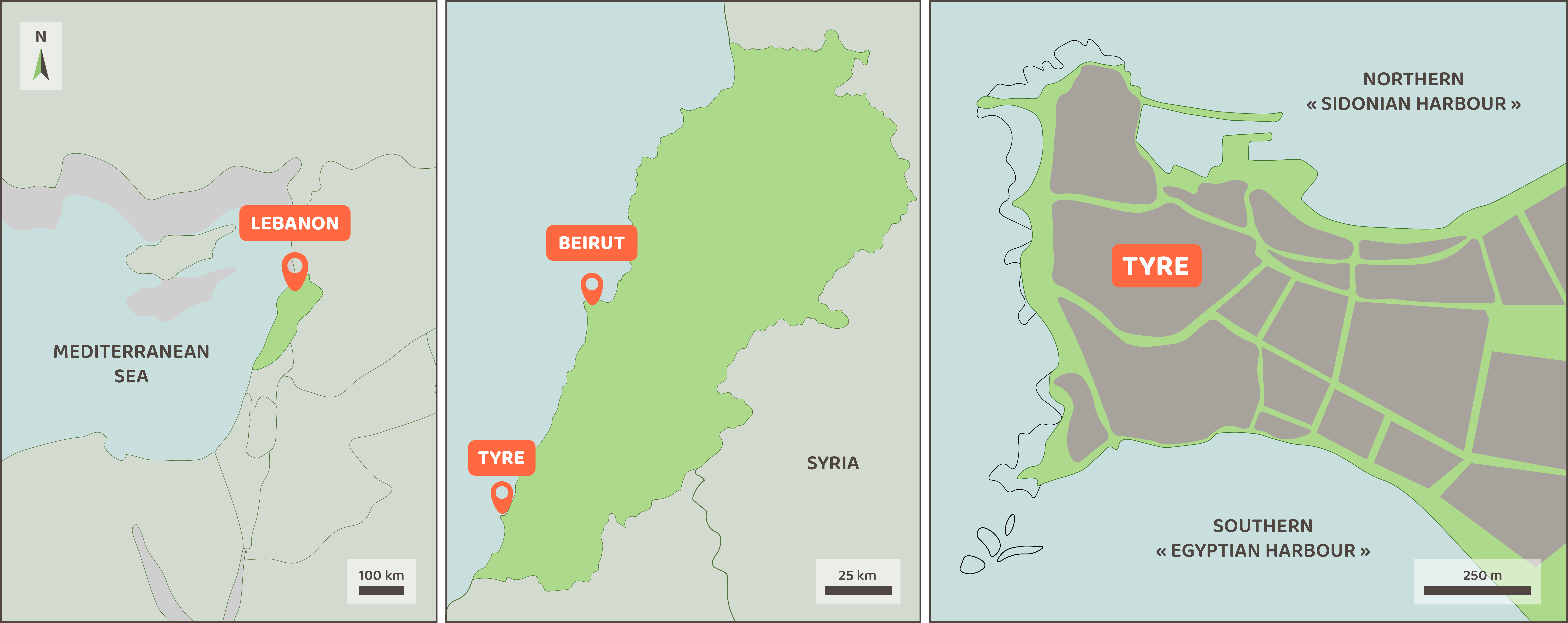
Location: 33.271N 35.194E
This page was prepared by Arthur de Graauw, Gilles Brocard, and Jean-Philippe Goiran. It features breaking news on the harbour history of Tyre, in particular the southern harbour, known as the “Egyptian Harbour”.
Introduction
The renowned Phoenician city of Tyre (Lebanon) is one of the finest examples of major changes triggered by the construction of a causeway affecting the development of its harbours. Building sustainable ports along coastlines is a difficult endeavour because coastlines are among the most rapidly changing landscapes on Earth. This challenge is faced worldwide today. Besides, the erection of coastal structures alters coastal dynamics in such a way that new structures tend to affect earlier constructions. The study of ancient harbours shows that it has been a nagging problem in coastal management since Antiquity. Therefore, investigating ancient cases is interesting because it provides more time depth into these changes than the modern cases, owing to the centuries of coastal changes that have elapsed since the structures started to alter their environment.
Tyre city was founded on a small coastal island from which it resisted invasions and sieges for many centuries. In 332 BCE, Alexander-the-Great eventually succeeded in seizing the city after building a causeway 4 stades[1] long and 2 plethra[2] wide, which was laid in water depths reaching 3 fathoms[3]. The causeway interrupted longshore sand transport, forcing sand to pile-up against and on top of the causeway, thus creating a sandy isthmus that has connected Tyre to the mainland ever since.
Where was the “Egyptian harbour”?
The isthmus profoundly altered the layout of Tyre and its harbours. Ancient authors Strabo (16, 2) and Arrian (2, 7), living in the first and second centuries CE, report that the Phoenician city had two harbours, one opening towards the north (the so-called “Sidonian Harbour”, or “Port of Astronoe”), and the other opening to the south (the so-called “Egyptian Harbour”). The ancient northern harbour is filled with Hellenistic to Byzantine sediments and is clearly documented below the modern harbour of Tyre (Marriner et al., 2005). The southern harbour no longer exists and several hypotheses for its location have been put forward over the past two centuries.
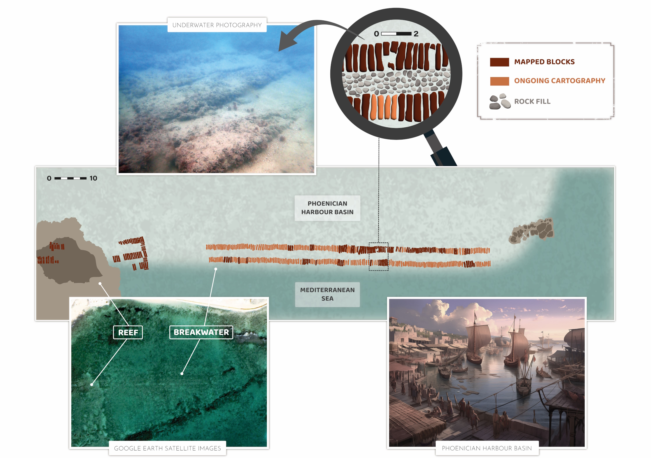
A breakwater, similar in style to the Phoenician breakwater built in the 6th-4th centuries BCE along the north coast (Nourredine, 2019), was identified in 2019 along the south coast by a team of researchers led by the Archéorient Laboratory, Maison de l’Orient et de la Méditerrannée, at the University of Lyon 2, France, by reinterpreting previously identified structures and improving the mapping (Goiran et al., 2021). Cores collected onshore by the team revealed the presence of sediments typically deposited inside a harbour basin, behind the offshore structure (Brocard et al., 2024) and samples of these sediments are currently being radiocarbon dated. The newly identified breakwater is therefore regarded as protecting the Egyptian Harbour of Tyre (“M” on the figure below). Its basin (“10” on the figure below) would have covered an area of up to one hectare (100 x 100 m), south of the Roman baths complex. The port structures of the southern Phoenician harbour of Tyre appear to have been buried during the Hellenistic and Roman periods, allowing the south-east corner of the island to be used by the Romans for the development of monumental baths. The team suggests that the southern harbour had to be abandoned owing to the rapid growth of a massive sandy isthmus during the centuries which followed the erection of Alexander’s causeway. The area of this southern harbour was then repurposed, with the building of monumental baths, and the development of an urban district protected by Roman-style seawalls. However, early Byzantine tomb stones of “murex fishermen of the Egyptian’s port” prove that the south port was still operational at that time, possibly just for beaching ships (Aliquot, 2020).
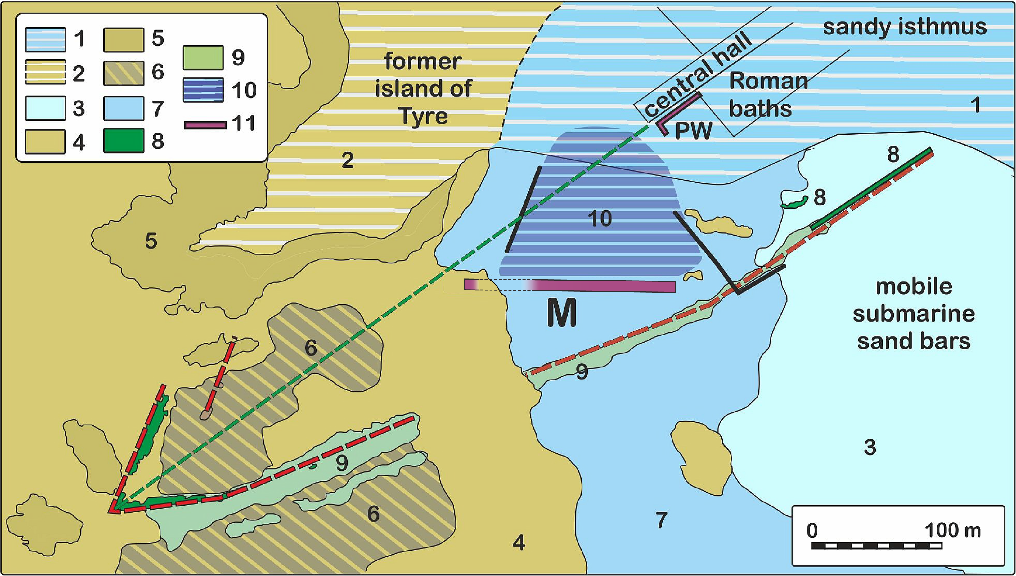
Red dashed line: Poidebard (1939)’s southern harbour enclosure. Green dashed line: axis of the monumental Roman baths. Geology: 1: emerged part of the sandy isthmus, 2: emerged land over calcarenite bedrock (wherever bedrock is above -2.5 m), 3: submarine part of the sandy isthmus, 4: submerged outcrops of calcarenite, 5: shore platform cut into calcarenite (mostly man-made), 6: natural block pavement over calcarenite, 7: natural block pavement over marine sediments, 8: roman concrete (opus caementicium), 9: rubble mound dyke, 10: proposed southern harbour-basin, 11 (M): east-west Phoenician-like breakwater.
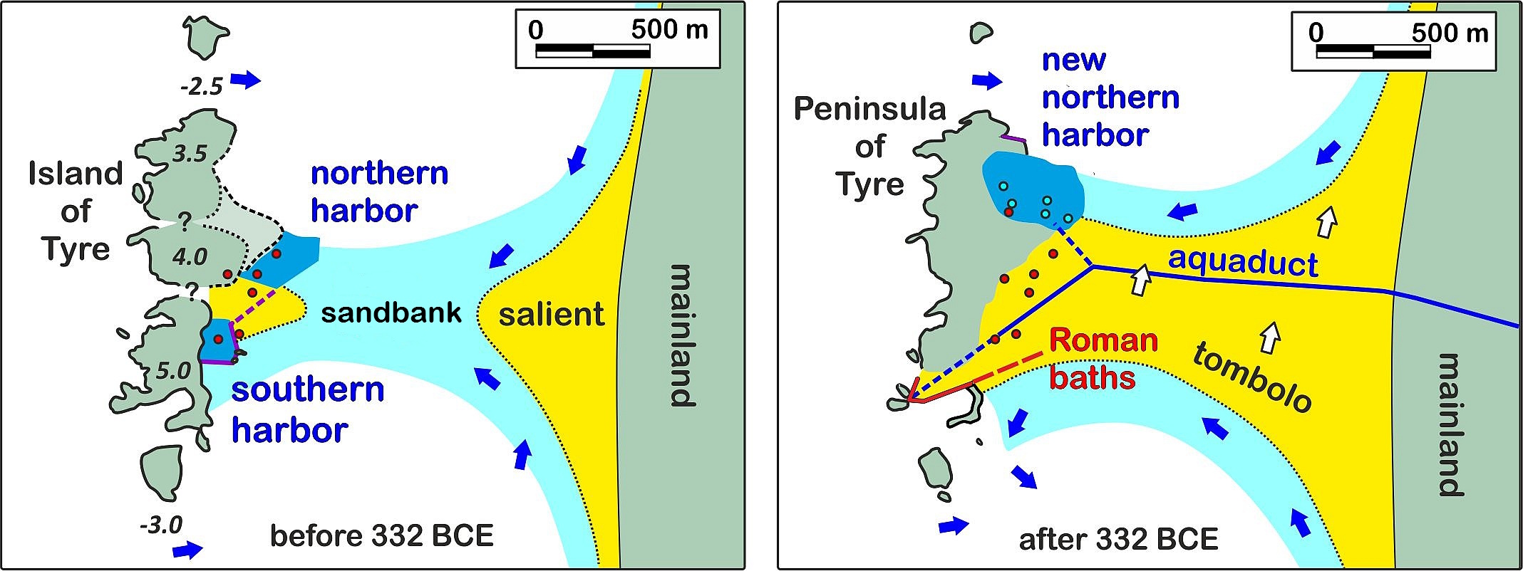
In addition, coring also revealed the presence of harbour sediments likely deposited in another basin, at an earlier location of the northern harbour of Tyre. This northern harbour would have been also abandoned to give way to the growing sandy isthmus, and relocated to its Hellenistic-Byzantine location, under the modern harbour of Tyre.
Tentative geomorphological chronology
The evolution of the marine landscape of Tyre was influenced by the development of the city well before Alexander’s conquest. Tyre started as a small offshore outpost of the city of Ushu, or Palaeotyre (Old Tyre), which was founded on the stretch of coast facing the island. Urban and port development really started on the island after 1 500 BCE (Bikai, 1987). Various archives indicate that some islets were then probably interconnected, enlarging the original island, and improving shelter from sea waves to such an extent that by 1 350 BCE, the Tyrian king Abimilky reportedly stationed battleships in a proto harbour in the lee of Tyre Island (Amarna Letter EA 153). As sedimentation in the lee of Tyre Island further progressed, a submarine sand bank formed, built by the refraction and diffraction of waves around the island. A large harbour was still present in the lee of the island by around 1 200 BCE (Anastasi 1 papyrus) but the accumulation of sand over the sand bank had led to its partial emergence, creating a coastal “salient” attached to the lee of the island. Around 950 BCE, famous Tyrian king Hiram I, friend of King David and King Solomon, connected one more islet to the main island, and reclaimed the area in between, which was called “Eurychoros” (wide space, agora) by Menander, according to Josephus Flavius (Apion, 1, 17-18, see full text hereafter). Hiram I obviously used the naturally formed salient and extended it through additional land reclamation. By then, the initial single harbour in the lee of the island had probably been largely occupied by the sand bank, and a new layout with two harbours had to be implemented, with a northern Sidonian Harbour and a southern Egyptian Harbour, set astride the growing sandbank. We do not know who might have carried out the work, possibly Hiram I himself, or one of his successors, possibly Ethbaal I around 875 BCE (Katzenstein, 1973). At that time, the southern harbour could have been the main one, as a north-south reef aligned with Tyre Island better protected the whole southern bay, which therefore could have been used as a summer anchorage area.
Both harbours were probably used for several centuries, while the city remained an island, as documented by the bronze bands of Balawat (858 BCE) and by Esarhaddon’s Annals (671 BCE). During that time the city prospered and resisted several important sieges (Salmanazar V, from 726 to 722 BCE, Nebuchadnezzar II, from 585 to 573 BCE), weathering also earthquakes and tsunamis (760-750 BCE, 590 BCE, 525 BCE, 199-198 BCE, 148-130 BCE, 92 BCE, 19 CE, 303 CE, 502 CE, 551 CE and many more after that) (Gatier, 2011a & Gatier, 2011b).
After Alexander-the-Great built his causeway, the tombolo formed, and the harbours were once again threatened by sand accumulation. The northern harbour was moved away from the tombolo, at its current location, below the modern harbour. The southern harbour, on the other hand, was abandoned. When the Romans arrived in the area in 64 BCE (Gatier, 2011b) they probably used sand removed during the levelling of the tombolo for further land reclamation and built the monumental Roman baths and an urban district starting in the 1st century CE. The research team suggested that the structures described by Poidebard (1939) are the Roman seawalls that protected this urban area from sea waves.
An estimated 2.5 m relative sea level rise affected the site, submerging the southern harbour structures. The age of this submergence is still poorly constrained, but it most likely occurred quite late during Antiquity, possibly in Hellenistic and/or Roman-Byzantine times (between say 500 BCE and 500 CE). The sea then overtook the seawalls of the southern district, gutted the Roman landfill, and unearthed the Phoenician quay- and breakwater-structures that were beneath it, exposing them on the seafloor.
How long did it take?
The research team conducted sand flux and sand volume calculations to provide a rough estimate of the time required for coastal processes to accumulate the sand volume currently contained in the peninsula that connects the former island of Tyre to the mainland.
The influence of tidal currents is negligible because the tidal range oscillates between 30 cm (neap tides) and 50 cm (spring tides). Longshore sediment transport is therefore determined by winds and waves (Nir, 1996). The sandy isthmus of Tyre started to form during the Roman Climatic Optimum (200 BCE-100 CE), the climate of which is regarded as similar to the present-day (Murray, 1987). The team therefore used the present-day wind and wave climate at Tyre (fr.wisuki.com) to assess sand fluxes at Tyre. The strongest winds (> 50 km/h) come from the southwest, with weaker winds (0-20 km/h) tracking from northwest. Waves come from a narrow western sector, with some northwest storms.
Littoral drift is quantified by several more or less complex formulae. The simplest was proposed by CERC (US Army Corps of Engineers) in 1984:
Q = K. H2.5. sin (2θ)
where Q is the littoral drift (in m3/year), K is a coefficient determined by sand grain size and by wave-breaker type (spilling or plunging), H is the wave height at breaking (in m), and θ is the angle (in °) of incidence of waves on the coastline at the breaker line. Littoral drift is nil for wave crests parallel to the coastline (θ = 0°), increases to a wave incidence up to 45° and diminishes at higher values.
At Haifa, to the south of Tyre, modern longshore drift moves 50 000-80 000 m3/yr of sand northwards (Zviely, 2007) for a mean incidence angle of waves of θ = 10°. Assuming this sand transport capacity at Haifa, the decrease in the incidence angle to θ = 6° at Tyre implies that longshore transport capacity at Tyre is reduced by a factor 0.6 to 30-50 000 m3/yr.
The total volume of sand accumulated behind Tyre Island was calculated as the difference between the elevation of the modern onshore and offshore surface of the sandy isthmus and the elevation of the substrate over which the sands were deposited. The resulting volume of sand accumulated behind Tyre Island before 332 BCE was estimated to 10 million m3, and the volume accumulated after 332 BCE, to 30 million m3 (Brocard et al. 2024).
This volume required 6 to 10 centuries to accumulate at a rate of 30 000 to 50 000 m3/yr, which means that the isthmus would have been able to reach its current size between the 3rd and the 7th century CE.
Conclusion
The harbour history of Tyre, spanning a period of 3 500 years, is one of abandonment and relocation of infrastructures, resulting in a complex pattern of structures, often superimposed one on top of the other. The development of many ancient ports was hampered at some point by a geological process of some sort, such as tectonic uplift or subsidence, soil settlement in deltas and estuaries, and, most commonly, by coastal progradation, either by direct ingress of fluvial sediments in estuaries and deltas, or by coastal accretion down drift of river mouths. There, man-made structures affect longshore sediment transport. For example, sand accumulated updrift (south) of the Roman port of Caesarea Maritima, but Tyre, in southern Lebanon, constitutes a remarkable case by the large amplitude of changes imparted by man-built structures. The only other case of such an amplitude is Alexandria (Egypt), and in both cases, the most important changes have been caused by… Alexander-the-Great.
Acknowledgements
Directorate General of Antiquities (DGA) of Lebanon. Mission Française Archéologique de Tyr supported by the French Ministry of European and Foreign Affairs (MEAE) and the IFPO (Institut Français du Proche Orient). Agence Nationale pour la Recherche ANR [AquaTyr, 2022]. Honor Frost Foundation. Geoarchaeologia society. INSH-Institut National des Sciences Humaines et Sociales (International mobility grant SMI).
Thanks to Sylvia Vinai for the nice pictures.
Thanks also to l’Orient-Le Jour for its attention.
Notes
[1] ca. 750 m, acc. to Quintus Curtius, 4, 2 & Diodorus Siculus, 17, 7, however, Pliny, 5, 17 mentions 700 paces, i.e., nearly 1 km.
[2] ca. 60 m, acc. to Diodorus Siculus, 17, 7.
[3] 5.4 m, acc. to Arrian, Anabasis, 2, 18.
References
ALIQUOT, J., 2020, The Port of Astronoe in Tyre, BAAL Hors-Série XVIII, (p 61-70).
AUBET, M., 2024, The Early Bronze Age in Tyre, Journal of Eastern Mediterranean Archaeology and Heritage Studies, Vol. 12, n° 3, (p 215-249).
AUBET, M., 2020, Tyre before Tyre: The Early Bronze Age Foundation, in: Nomads of the Mediterranean: Trade and Contact in the Bronze and Iron Ages, Brill, Leiden, (p 14-30).
BIKAI, P. & P., 1987, Tyre at the End of the Twentieth Century, Berytus, Archaeological Studies, 35, (p 67-96).
BROCARD, G., GOIRAN, J-P., DE GRAAUW, A., et al., 2024, Growth of the sandy isthmus of Tyre and ensuing relocation of its harbors, Quaternary Science Reviews, Vol 324, Elsevier.
CERC, 1984, Coastal Engineering Research Center of the US Army Corps of Engineers, Shore Protection Manual, Vol. I, (652 p), and US Army Corps of Engineers, 2004, ERDC/CHL CHETN-IV-62, (13 p).
GATIER, P-L., 2011, Tyr l’instable: pour un catalogue des séismes de l’Antiquité et du Moyen Âge, in Sources de l’Histoire de Tyr, Presses de l’IFPO, (p 255-265).
GATIER, P-L., 2011, Mission archéologique de Tyr, Rapport Préliminaire 2008-2009, BAAL 14, (106 p).
GOIRAN, J-P., BROCARD, G., DE GRAAUW, A., et al., 2021, Evolution of Sea Level at Tyre During Antiquity, BAAL 21, 2021, (p 305-317).
KATZENSTEIN, J., 1973, The History of Tyre, From the Beginning of the Second Millennium B.C.E. until the Fall of the Neo-Babylonian Empire in 538 B.C.E., Schocken Institute for Jewish research, Jerusalem, (373 p).
MARRINER, N., MORHANGE, C., BOUDAGHER-FADEL, M., BOURCIER, M., CARBONEL, P., 2005, Geoarchaeology of Tyre’s ancient northern harbour, Phoenicia, Journal of Archaeological Science. 2005, 32(9), (p 1302-27).
MURRAY, W., 1987, Do modern winds equal ancient winds? Mediterranean Historical Review, 2, (p 139-167).
NIR, Y., 1996, The city of Tyre, Lebanon and its semi-artificial tombolo, Geoarchaeology, 11, (p 235–250).
NOUREDDINE, I., 2019, Harbour Installations at Tyre North, in In the Footsteps of Honor Frost. The life and legacy of a pioneer in maritime archaeology, Sidestone Press, Leiden, (p139-150).
POIDEBARD, A., 1939, Un grand port disparu, TYR. Recherches aériennes et sous-marines, Librairie orientaliste Paul Geuthner, Paris, (128 p).
ZVIELY, D., KIT, E., KLEIN, M., 2007, Longshore sand transport estimates along the Mediterranean coast of Israel in the Holocene, Mar. Geol. 238, (p 61–73).
Ancient references
The following ancient documents mention the port of Tyre (in chronological order):
Amarna Letters, 77 & 89 & 92 & 114 & 146-155 (1360-1332 BCE)
Ugarit tablet RS 18.031 (ca. 1200 BCE)
Anastasi Papyrus (ca. 1200 BCE)
Wenamon’s trip (ca. 1080 BCE)
Assur-Nasir-Pal, Annals, Col III (883-858 BCE)
Balawat bronze bands (858 BCE)
Nimrud Letter 12 (ca. 720 BCE)
Esarhaddon’s Annals (681-669 BCE)
Esarhaddon’s treaty (ca. 671 BCE)
Herodotus, Hist, 2, 44 (ca. 485-425 BCE)
Pseudo Scylax, Peripl (4th c. BCE)
Zenon’s papyri (259-255 BCE)
Polybius, Hist, 5, 14 (130 BCE)
Diodorus Siculus, Hist, 17, 7 & 17, 46 & 19, 58 & 19, 62 (49 BCE)
Strabo, Geogr, 16, 2 (24 CE)
Quintus Curtius, Hist, 4, 2 (ca. 50 CE)
Pliny, Nat. Hist, 5, 17 (77 CE)
Josephus Flavius, Apion, 1, 17-18 (after 94 CE)
Plutarch, Alexandre, 32 (ca. 100 CE)
Arrian, Anabasis, 2, 7 (150 CE)
Bible, Isaiah 23:1, Ezezkiel 26:8, Ezekiel 27:1, Ezra 3:7, 1 Kings 5:9, Acts 21:3 (1st-3rd c. CE)
Xenophon of Ephesus, Ephesian Tale, 1, 14 (2nd or 3rd c. CE)
Benjamin of Tudela, Itinerary (p 18) (ca. 1170 CE)
Description of Phoenician Tyre by Josephus Flavius, Contra Apionem, 1, 17-18, dated after 94 AD
(transl. W. Whiston, 1737, London)
17. […] This Dius therefore writes thus, in his histories of the Phoenicians: “Upon the death of Abibalus, his son Hiram [the first] took the Kingdom. This King raised banks at the eastern parts of the city and enlarged it. He also joined the temple of Jupiter Olympus, [Tyrian Baal] which stood before in an island by itself, to the city, by raising a causeway between them, and adorned that temple with donations of gold. He moreover went up to Libanus, and had timber cut down for the building of temples. […]
18. And now I shall add Menander the Ephesian, as an additional witness. This Menander wrote the acts that were done both by the Greeks and Barbarians, under every one of the Tyrian kings, and had taken much pain to learn their history out of their own records. Now when he was writing about those kings that had reigned at Tyre, he came to Hiram and says thus: “Upon the death of Abibalus, his son Hiram took the Kingdom. He lived fifty-three years and reigned thirty-four. He raised a bank on that called the broad place [Eurychoros] and dedicated that golden pillar which is in Jupiter’s temple. He also went and cut down timber from the mountain called Libanus and got timber of cedar for the roofs of the temples. He also pulled down the old temples and built new ones. Besides this he consecrated the temples of Hercules [Tyrian Melqart] and of Astarte.” […]
Description of Phoenician Tyre by Herodotus, History, 2, 44, dated ca. 450 BCE
(transl. A. D. Godley, 1920-25)
44. Moreover, wishing to get clear knowledge of this matter whence it was possible so to do, I took ship to Tyre in Phoenicia, where I heard that there was a very holy temple of Heracles [Tyrian Melqart]. There I saw it, richly equipped with many other offerings, besides that in it there were two pillars, one of refined gold, one of emerald, a great pillar that shone in the night-time [a lighthouse?]; and in converse with the priests, I asked how long it was since their temple was built. I found that neither did their account tally with the belief of the Greeks, for they said that the temple of the god was founded when Tyre first became a city, and that was two thousand three hundred years since.
Nabuchodonosor’s ramp in A Prophecy Against Tyre by Ezekiel 26:8, dated 1st-3rd c. CE
(transl. https://www.biblegateway.com )
7. For this is what the Sovereign Lord says: From the north I am going to bring against Tyre Nebuchadnezzar, king of Babylon, king of kings, with horses and chariots, with horsemen and a great army.
8. He will ravage your settlements on the mainland with the sword; he will set up siege works against you, build a ramp up to your walls[1] and raise his shields against you.
9. He will direct the blows of his battering rams against your walls and demolish your towers with his weapons. […]
[1] Translations for this structure differ, some use the word “ramp”, others speak of a “mount”. We could imagine a mount reaching the top of the wall (150 feet high acc. to Arrian, 2, 7, that is 45 m), like the one built by the Romans to seize the Massada fortress. However, on Tyre Island, such a mount would extend into the water at least 100 m from the foot of the wall. In addition, a causeway from the mainland would be needed to transport the materials for building the ramp. None of this has been substantiated by archaeology so far.
Description of Alexander’s causeway by Diodorus Siculus, Hist, 17, 7 (or 40-46), dated 49 BC
(transl. Charles Henry Oldfather, 1933)
40.4. The king saw that the city could hardly be taken by sea because of the engines mounted along its walls and the fleet that it possessed, while from the land it was almost unassailable because it lay four stades [630-740 m] away from the coast. Nevertheless, he determined to run every risk and make every effort to save the Macedonian army from being held in contempt by a single undistinguished city.
40.5. Immediately he demolished what was called Palaeotyre [Old Tyre] and set many tens of thousands of men to work carrying stones to construct a mole two plethra in width [61 m]. He drafted into service the entire population of the neighbouring cities and the project advanced rapidly because the workers were numerous.
42.5. […] As his engines drew close to the city and its capture seemed imminent, a powerful north-west gale blew up (“ἀργέστης ἄνεμος μέγας” Argestes meaning a N300° wind direction) and damaged a large part of the mole.
42.6. Alexander was at a loss to deal with the harm done to his project by the forces of nature and thought of give up the siege attempt but driven by ambition he sent to the mountain and felling huge trees, he brought them branches and all and, placing them besides the mole, broke the force of the waves [note the trees are not used for the mole itself, but to protect the ongoing works].
42.7. It was not long before he had restored the collapsed parts of the mole, and pushing on with an ample labour force until he came within missiles’ range, he moved his engines out to the end of the causeway, and attacked the walls with his stone throwers, while he employed his light catapults against the men stationed along the battlements. The archers and slingers joined in the barrage and wounded many in the city who rushed to the defence.
43.5. […] Now the causeway had reached the wall and made the city mainland, sharp fighting took place along the walls.
43.6. The Tyrians had the present danger before their eyes and easily imagined what a disaster the actual capture of the city would be, so that they spent themselves so freely in the contest as to despise mortal danger.
46.1. Alexander addressed the Macedonians, calling on them to dare no less than he. Fitting out his ships for fighting, he began a general assault upon the walls by land and sea and this was pressed furiously. He saw that the wall on the side of the naval base was weaker than elsewhere and brought up to that point his triremes lashed together and supporting his best siege engines.
Description of Alexander’s causeway by Arrian, Anabasis of Alexander, 2, 18, dated 150 AD
(transl. Edward James Chinnock, 1920)
18.1. […] he resolved to construct a mole from the mainland to the city. The place is a narrow strait full of pools; and the part of it near the mainland is shallow water and muddy, but the part near the city itself, where the channel was deepest, was about about three fathoms [5.4 m]. in depth. But there was an abundant supply of stones and wood, which they put on the top of the stones. Stakes were easily fixed down firmly in the mud, which itself served as a cement to the stones to hold them firm. The zeal of the Macedonians in the work was great, and it was increased by the presence of Alexander himself, who took the lead in everything, now rousing the men to exertion by speech, and now by presents of money lightening the labour of those who were toiling more than their fellows from the desire of gaining praise for their exertions. As long as the mole was being constructed near the mainland, the work made easy and rapid progress, as the material was poured into a small depth of water, and there was no one to hinder them; but when they began to approach the deeper water, and at the same time came near the city itself, they suffered severely, being assailed with missiles from the walls, which were lofty, inasmuch as they had been expressly equipped for work rather than for fighting. Moreover, as the Tyrians still retained command of the sea, they kept on sailing with the triremes to various parts of the mole and made it impossible in many places for the Macedonians to pour in the material. […]
Description of Alexander’s causeway by Quintus Curtius, History, 4, 2-3, dated ca. 50 AD
(transl. J.C.Rolfe, Loeb, 1946)
2, 7. But the Tyrians, having plenty of confidence in their situation, had decided to sustain a siege; for a strait of four stadia separates the city from the mainland and was especially exposed to the Africa wind [SW wind], which rolls upon the shore wave on wave from the deep. And there was nothing which more than that wind stood in the way of receiving the work by which the Macedonians were preparing to join the island to the mainland. Even with a calm and mild sea foundations can only with difficulty be laid, while the Africa wind, by the blows of the sea as it dashes against them undermines all the first structures, and no mass is so firm that the waters do not eat it away, both by trickling through the joints of the works, and when a more violent wind rises, by pouring over the top of the entire structure. Besides this difficulty there was another equally great. The walls and towers of the city were surrounded by very deep sea; […]
2, 19. A great amount of rocks was available, supplied by Palaeotyre [Old Tyre], timber was brought from Mount Libanus for making rafts and towers. And already the work had grown from the bottom of the sea to a moderate height, but nevertheless had not yet reached the surface of the waters, when the Tyrians, bringing up some small boats, mocked them with the taunt that those men famous in arms were carrying loads on their backs like beasts of burden; they also asked whether Alexander was greater than Neptune. These very insults inspired the soldiers to greater eagerness. And now the massive structure was rising a little above the water and at the same time the causeway was increasing in width and moving towards the city, when the Tyrians, seeing the size of the structure, whose increase had hitherto escaped their notice, began to encircle with light craft the work which did not yet form a juncture, and also to assail with missiles those who stood upon it. […]
3, 6. On that day a more furious wind stirred up the sea from its very depths and dashed it against the causeway, and the joints of the structure, lashed by surge after surge, loosened, so that the sea, flowing in between the blocks, broke right through the work. Therefore, when the heaps of stones which supported the earth that had been heaped upon them were demolished, the whole structure sank headlong into the deep, and Alexander, on returning from Arabia [Mont Liban], found hardly any traces of so great a causeway. Thereupon, as usually happens in disasters, they all put the blame on one another, although all might more reasonably have found fault with the fury of the sea. The king, on beginning to build a new causeway, made its front (instead of its side) face directly into the unfavourable wind [interpretation is difficult as the mole could not be built towards the NW or SW wind direction, as it would miss Tyre Island]. Thus, the front protected the rest of the works, which were hidden, as it were, behind it; he also made the causeway wider, in order that the towers erected on the middle of it might be far out of range of a weapon. Furthermore, they threw whole trees with their great branches into the deep, then loaded them with rocks, again threw other trees upon the pile of rocks, and finally heaped on earth; besides this, by piling up successive masses of rocks and trees they had joined together a continuous causeway, as if by a kind of bond. […]