67 ancient ports have so far been identified on both sides of the Bosphorus (see the Catalogue), but our aim in this section is to study the process of infilling of the Black Sea that took place around 8400 14C years BP (possibly around 6800 calendar years BC) (Wikipedia).

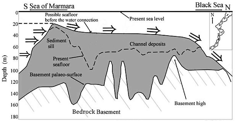
The Bosphorus is the northern part of the connection between the Mediterranean Sea and the Black Sea. It consists of a canyon 31 km long and around 3000 m wide at both entrances, but its narrowest section is only 700 m wide. One might distinguish a narrow part 24 km long and around 1 km wide between Dolmabatçe Palace near Istanbul and Yavuz Sultan Selim bridge at the northern end, even if that is quite a rough schematisation. The water depth varies between 13 and 110 m. As a matter of fact, the whole stream behaves much like a river with several curves and lateral deep and shallow areas. The bottom consists of alluvial sediment over a thickness ranging from 10 to 100 m on top of a bedrock basement[0].
Considerable volumes of water are exchanged through the Bosphorus between both adjacent seas. Inflow of salty water from the Mediterranean Sea into Black Sea (ca. 11 000 m3/s or 350 km3/year) flows underneath a less salty water outflow from the Black Sea into the Mediterranean Sea (ca. 16 000 m3/s or 500 km3/year). As can be expected, the outflow equals the inflow + discharge of rivers (Danube, Dnieper, Don) + rainfall – evaporation. The figures given above are obviously averaged [1].
It is accepted that the Black Sea was once a fresh-water lake disconnected from the Mediterranean Sea by a sediment sill in the Bosphorus located around -36 m below present sea level (deepest spot of the shallowest cross-section in the present Bosphorus, located in front of Dolmabahçe Palace).
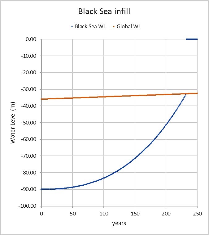
This configuration existed until around 7000 BC when, due to global eustatic Sea Level Rise (SLR), Mediterranean water started to flow over the sediment sill into the Bosphorus and Black Sea-lake. The somewhat controversial questions are: how deep was the lake water level at that time, and how fast did the water level rise? Even if the lake water level was much deeper than the Bosphorus sill, e.g. -80 to -100 m acc. to Yanchilina (2017)[3], flooding must have been rather progressive because, at that time, global SLR was around 14 mm/year … unless the sill in the Bosphorus collapsed, or was massively eroded.
In any case, scholars agree on the fact that after reconnection with the Mediterranean Sea, the Black Sea water level more or less followed the global eustatic SLR. This means that Neolithic and Bronze Age settlements were not affected by the controversy about the Black Sea water levels, i.e. Neolithic settlements dated around 6000-3000 BC might be found at less than 15 m depth below the present sea level.
Let’s get back to the question of how fast the Black Sea water level rose by means of some hydraulic computations with a time-step of one year. We have a formula for the water discharge over a sill as a function of the upstream water level (WL). With this, we can compute the flow velocity inside the schematised Bosphorus. With this velocity, we can compute the volume of sediment transported by the flow as a function of the sediment grain-size. This leads to a rate of erosion of the bottom of the Bosphorus. This in turn gives a new bottom position for the computations to be done for the next year, and so on, until the water level in the Black Sea reaches the Global WL. Obviously, this is a simple approach with rough schematisations and several assumptions for which we will have to perform a sensitivity analysis. However, this approach will show the hydrodynamics and may give an order of magnitude of the water level rising speed in the Black Sea.
Computation details:
Computations were performed on a simple Excel spreadsheet, with one year per line. The input parameters are:
- Sill crest-level at the beginning of overflowing (set
to -36 m below present sea level), - Water level in the Black Sea at the beginning of
overflowing (set to -90 m below present sea level), - Rate of Global Sea Level Rise (set to 14 mm/year),
- Sediment grain-size on the crest of the sill and the
bottom of the Bosphorus (D50, median diameter, set to 20 mm), - Density of sediment grain-size on the crest of the
sill and the bottom of the Bosphorus (Delta, set to 1.65, as for common stone), - Bosphorus schematised to a prismatic section (width of
1 km, length of 24 km).
The upstream water level at the sill is the Global WL which starts to overflow the sill in year 1. The initial discharge is obviously very small as the water sheet on top of the sill is only 14 mm. Therefore, the flow velocity inside the Bosphorus is too small to induce any erosion. But after a number of years, erosion starts, and processes accelerate drastically, e.g. the water sheet on the crest of the sill reaches several meters. After some more years, the water level in the Black Sea reaches the Global WL and the infilling process terminates.
Formulation[4]:
H: water depth on sill: WL at sill – sill-level (including erosion of previous year) (m)
Q: discharge over sill with sill formula: Q = 1.5 b H1.5
with Q = V b (m3/s)
V: flow velocity on sill (m/s)
b: constant sill width and Bosphorus width (m)
C: Chézy friction coefficient: C = 18 Log (12 H/D50) (m1/2/s)
i: slope of water surface deduced from Chézy formula:
i = (V/C)2/H (-)
Vo: flow velocity at initiation of movement of sediment with D50 and Delta: Vo = 0.2 C sqrt(Delta D50) (m/s)
Delta : relative density of sediment (e.g. 1.65 for granite) (-)
D50: median diameter of sediment (m)
Qo: discharge at initiation of sediment movement: = Vo b H (m3/s)
Qs: sediment discharge acc. to Meyer-Peter formula:
Qs = 0.91 i7/6 [1 – (Qo/Q)3/8] Q (m3/s)
Erosion: yearly eroded layer in schematised Bosphorus (m/year)
Yearly discharge of water over sill (km3/year)
Cumulated volume of infill water flowing into the Black Sea (km3 = 1000 Million m3)
Cumulated volume of erosion of the Bosphorus bottom (Million m3)
Computation results:
As explained above, the Global WL increases each year and so does the discharge over the sill. After some time (around one century), erosion of the crest of the sill and of the bottom of the Bosphorus starts. This accelerates the processes and after some more time (another century), the Black Sea water level reaches the Global WL.
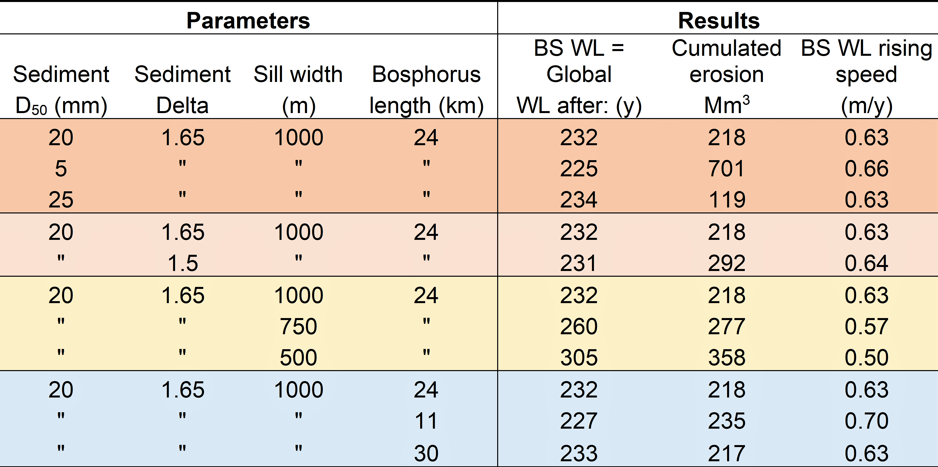
With the parameter settings given above, the detailed computation results are as follows:
- No erosion occurs during the first 128 years.
- The Black Sea is completely filled when its WL reaches the Global WL of that time, that is after: 232 years, with sediment D50 = 20 mm.
- At that time, cumulated erosion in the Bosphorus is: 218 Mm3, which is close to the 200 Mm3 estimated by Gökasan et al. (2005) and Lericolais et al. (2019)[5].
- The infill process is thus quite progressive: The Black Sea WL rising speed is never larger than 1 m/year. Hence, no catastrophic deluge.
These results are valid for the above-mentioned parameter settings only. Some of the parameter values are rather uncertain and it is therefore required to check the sensitivity to parameter variations.
Sensitivity analysis
Hence,
- Reducing sediment D50 leads to a large
increase of the eroded volume and it would be really useful to find more
information on the sediment characteristics on the bottom of the Bosphorus, - Reducing sediment Delta (e.g. changing from granite to
limestone) leads to an increased eroded volume, - Reducing the Bosphorus width leads to an increased
eroded volume, - Changing the Bosphorus length leads to small changes
in results.
Conclusion:
This simple hydraulic computation with a sill at -36 m shows that a 14 mm/year global sea level rise would induce a rise of the Black Sea level (from -90 m to -36 m) within around 200-300 years, inducing a gradually increasing water level rise in the Black Sea never exceeding 1 m/year. This is fast, but it is not a catastrophic flood. The « deluge hypothesis » could therefore only be explained by a sudden collapse of (a part of) the Bosphorus sill, perhaps during an earthquake, but there is no archaeological evidence (yet) for this.
Notes
[0] ALGAN, O., et al., 2001, “Stratigraphy of the sediment infill in Bosphorus Strait: water exchange between the Black and Mediterranean Seas during the last glacial-Holocene”, Geo-Marine Letters 20(4), p 209-218.
[1] GREGG, M., & Özsoy, E., 2002, “Flow, water mass changes, and hydraulics in the Bosphorus”, J. Geophys. Res., Vol. 107, DOI 10.1029/2000JC000485, (23 p).
Note that today’s salinity of deep Black Sea waters (below 200 m depth) is still no more than 22 psu compared to 34 psu for Med waters (psu: Practical Salinity Unit, or g/kg). This means that some mixing between fresh surface waters and deeper waters occurs, yielding a stable 22 psu deep salinity and 17 psu surface salinity. Caricaturing, it is not 0 psu at the surface and 34 psu at the bottom, but resp. 17 and 22.
Another note is to compare the less salty water outflow from the Black Sea into the Mediterranean Sea (ca. 16 000 m3/s) to the less salty water inflow from the Atlantic Ocean into the Mediterranean Sea of around one million m3/s.
[2] GÖKASAN, E., et al., 2005, “Evidence and implications of massive erosion along the Strait of Istanbul (Bosphorus)”, Geo-Mar. Lett. 25, p 324–342, DOI 10.1007/s00367-005-0216-3.
[3] YANCHILINA, A., et al., 2017, “Compilation of geophysical, geochronological, and geochemical evidence indicates a rapid Mediterranean-derived submergence of the Black Sea’s shelf and subsequent substantial salinification in the early Holocene”, Marine Geology, 383 (2017), p 14-34.
See also a nice summary of this controversy by:
YANKO-HOMBACH, V., et al., 2011, “Was the Black Sea Catastrophically Flooded during the Holocene? – geological evidence and archaeological impacts”, in “Submerged Prehistory”, ed. J. Benjamin, et al., Oxford Books, 2011, (p 245-262), concluding that “there is no underwater archaeological evidence to support any catastrophic submergence of prehistoric Black Sea settlements during the Late Pleistocene or Early Holocene intervals”.
See also: “Noah’s Not-so-big Flood”, 2009, by Lonny Lippsett, https://www.whoi.edu/oceanus/feature/noahs-not-so-big-flood/.
[4] All hydraulic formulae used in this section are well known to river hydraulicians, the Meyer-Peter sediment discharge formula is to be found in:
COUVERT, B., et al., 1999, “La gestion des rivières, Transport solide et atterrissements”, Les études des agences de l’eau, N° 65.
[5] LERICOLAIS G, et al., 2019, “Overview of the Bosphorus Depositional Fan from Data Sets Recovered on the Black Sea Shelf off the Strait of Istanbul”. Int J Environ Sci Nat Res. 2019; 17(1): 555959, DOI: 10.19080/IJESNR.2019.17.555959. 016.