Location: 30°N 48.5°E
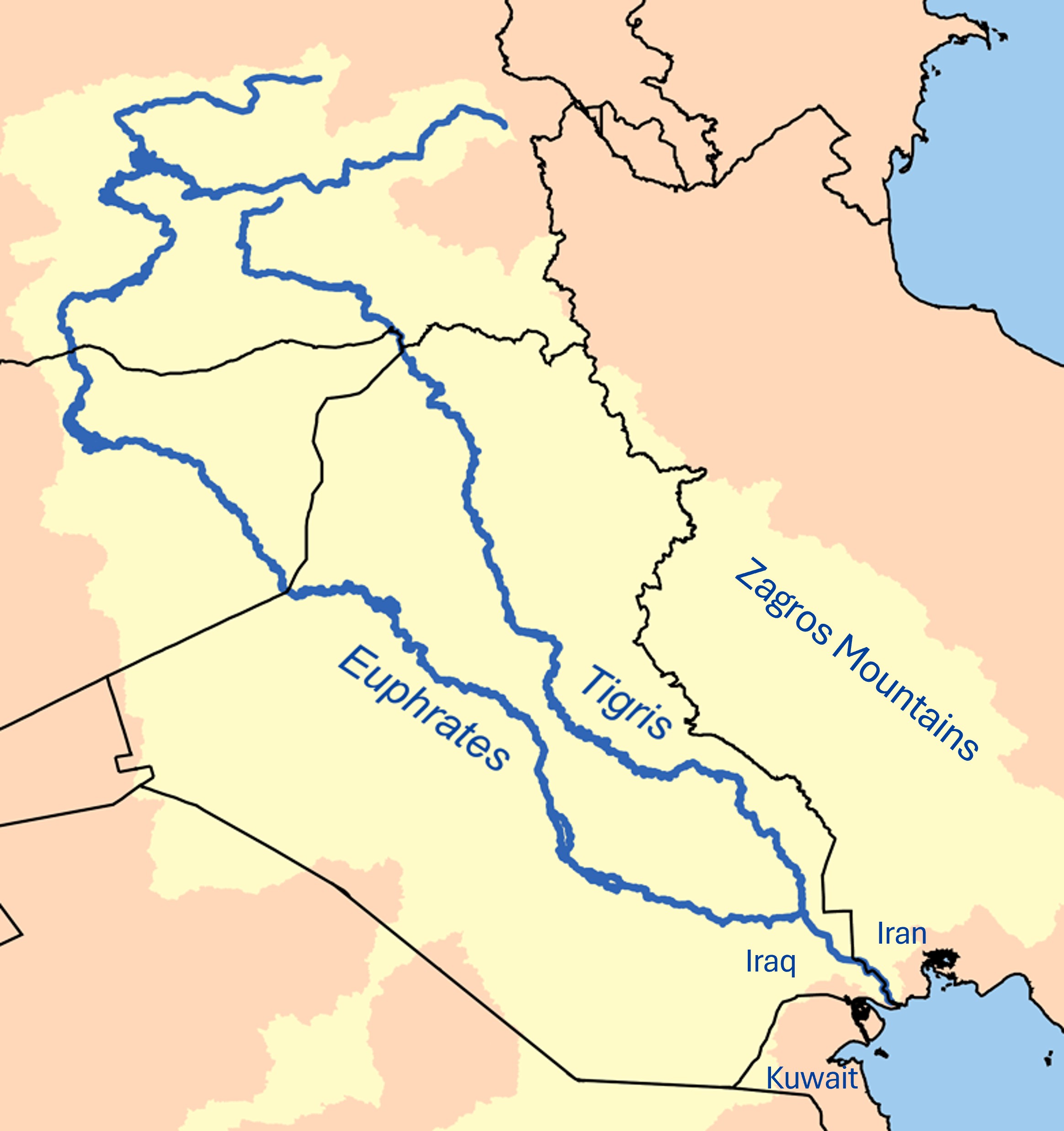
The Tigris-Euphrates “delta” is singular as it comprises two major rivers, (Tigris and Euphrates) and several local rivers from the Zagros Mountains. In that sense, it differs from the Nile or other deltas where a single river splits up into several branches. The total sea-front width of the delta is around 140 km covering three modern countries (Kuwait, Iraq, Iran). Our aim is to reconstruct the evolution of this ancient delta by means of geomorphological and archaeological data, and with textual descriptions by ancient authors. However, this task is very challenging given the scarcity of data (Adams, 1981; Pournelle, 2003 & 2007; Sherratt, 2004; Cole & Gasche, 2007; Walstra et al., 2010; Heyvaert et al., 2012-2013; Verkinderen, 2015; Giosan & Goodman, 2025), along with modern war damage and land reclamation (Curtis, 2008).
Thanks to Martin Sauvage’s recent mapping (Sauvage, 2020) and to geomorphological studies (Heyvaert, 2013; Sanlaville, 1989), we can provide a rough picture of the geomorphological evolutions of the delta since ancient times. Furthermore, some ancient texts reference rivers and locations in the delta. Since these sources date from the 1st c. CE (Strabo, Pliny), from the 2nd c. CE but reporting on a 4th c. BCE description (Arrian), and from the 5th c. CE (Marcian), the descriptions may reflect historical geomorphological evolutions and changing place-names over time (see appended texts hereafter), and distances mentioned in these ancient texts are obviously approximate.
With these constraints in mind, we will attempt to reconstruct the ancient delta.
It is difficult to give an overview on such a small map, but please refer to the attached kml file to be used with Google Earth.
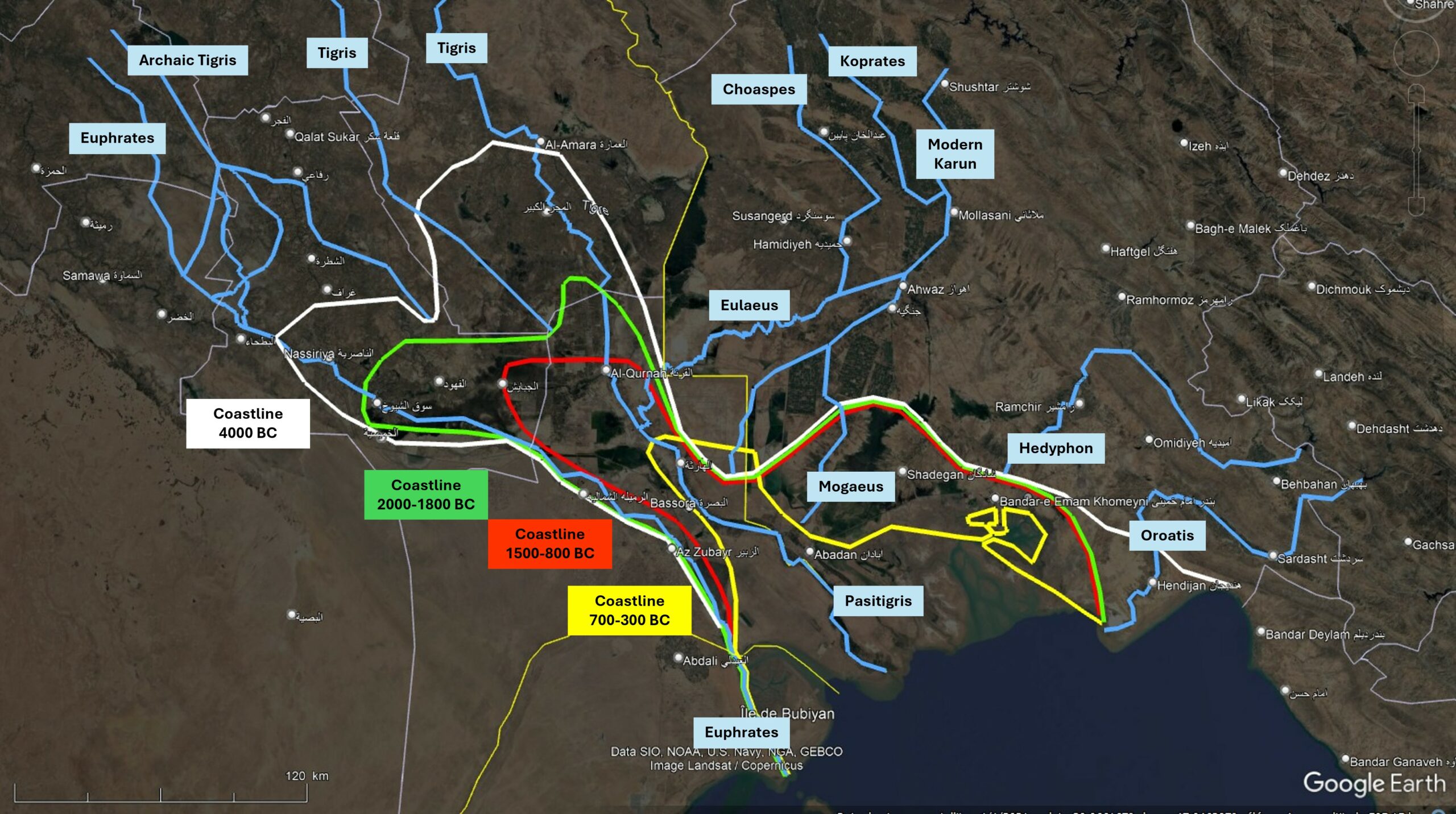
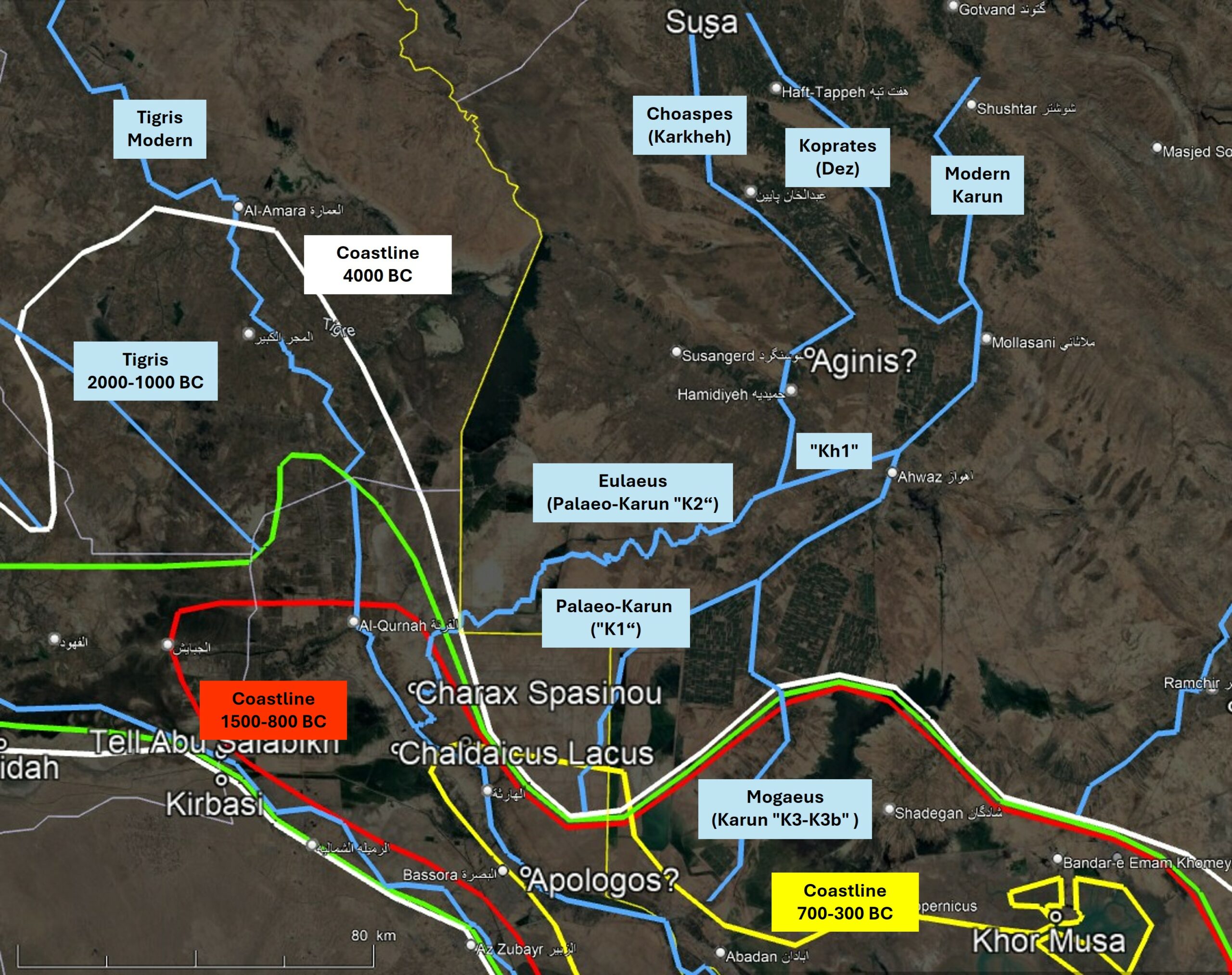
During the Holocene sea level rise, sea level “stabilised” around 3-4 m below present Mean Sea Level between 5000-4000 BCE (7000-6000 BP). From this time onwards, the progradation of river sediments was stronger than marine transgression, so that many deltas in the world advanced towards the sea. During the past five millennia, both the Tigris and the Euphrates brought much fine silty sediment to the delta, and local rivers like the Karun produced coarser sediment. The map above shows that in 2000 BCE, both main rivers still had separate outlets (green coastline). The famous city of Uruk was near the outlet of the Euphrates. Lagash was on an ancient track of the Tigris while the river was moving eastward and gradually filling the northern bay near al-Amara (Aqrawi, 2001). Around 1000 BCE, both major rivers had their outlet in the area of modern al-Qurnah (red coastline), where they still converge today in extensive marshlands. From that time until the present, sedimentation has caused the lake’s outlet (Pasitigris River, now called Shatt el-Arab) to extend further south-eastward towards the sea (yellow coastline).
On the north side of the Pasitigris, the outlet of the Eulaeus (modern Karun) built a large alluvial fan of coarser sediment than that of the Tigris-Euphrates, and similarly, on the south side, the Batin provided large volumes of coarser sediment that further pinched the Pasitigris. As the slow-flowing Pasitigris could not erode all these sediments, large lakes and marshes formed upstream of Basra. In addition to these geomorphological evolutions, compaction and tectonic movements probably induced relative sea level changes (Sanlaville, 1989).
A list of the rivers and places is drawn up hereafter from West to East, with places from upstream to downstream. It is to be noted that, early in 324 BCE, Nearchus travelled from East to West, sailing some rivers upstream from the sea, he was therefore present in several places (Vincent, 1797).
River Euphrates: around 2800 km long, flowing on the western side of Mesopotamia, on Khor al-Zubayr with an ancient 4th c. BCE outlet on Khor al-Subiya, west of Bubiyan Island (Kuwait) (Wikipedia, Hansman, 1978).
The following places may be considered as ports on the Euphrates:
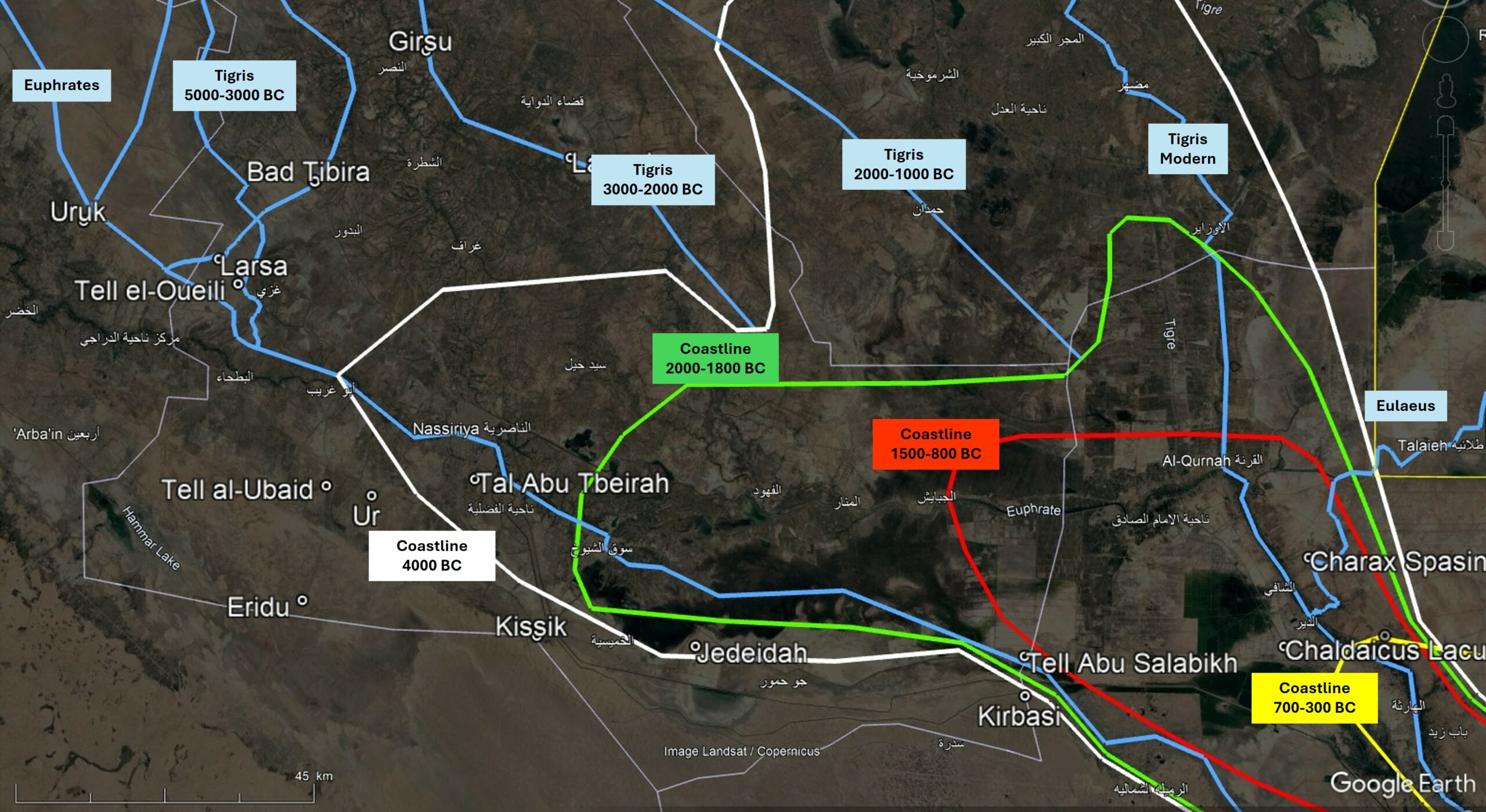
4000 BCE (white coastline)
and 1500-800 BCE (red coastline).
- Uruk (also: Orchoe, Erech, Orikut, Borcoe?) founded around 4000 BCE at Tell al-Warka (Pournelle, 2003 & 2007).
- Ur (also: Uri, Sumerian Urim) founded around 4000 BCE at Tell el-Muqayyar, with “two off-river basins enclosed within the walls of Ur” (acc. to Blackman, 1982, p 92) (Curtis et al., 2008).
- Larsa (also: Larancha, Laranchon, Biblical Ellasar) founded around 3000 BCE at Tell as-Senkereh, with a harbour basin (Vallet, 2024).
- Tell Abu Tbeirah, 15 km east of Ur, dated 2900-2000 BCE (D’Agostino and Romano, 2013).
- Kissik (also: Kisig, Kuara) at Tell al-Lahm, 33 km SE of Ur, dated 2900-2000 BCE (Wikipedia, Curtis et al., 2008).
- Jedeidah, 54 km SE of Ur, probably operational around 2000 BCE (Djabellaoui, 2020).
- Tell Abu Salabikh, 102 km SE of Ur, operational around 1500 BCE as a capital city of the “The Sealands” (Hritz, Pournelle and Smith, 2013).
- Kirbasi, 103 km SE of Ur, 6 km due South of Tell Abu Salabikh, probably operational around 1500 BCE (Djabellaoui, 2020).
- Teredon (also: Teriton (Pliny), Didotis, Diritotis (Arrian), Adarou (Ptolemy), Adarupolis (Marcian)), on the Euphrates: very uncertain location north of Bubiyan island, said to have been founded around 600 BCE (Salles, 2012).
It is observed that places tend to emerge in synchrony with the progression of river sedimentation at the mouth of the Euphrates.
Ikaros, Icarus insula (also: Akarum, Agarum, Ichara, Marcian’s Apphana insula?) is mentioned by Strabo (16, 3) and Arrian (Anabase, 7, 5), belonging to the archaic Dilmun empire, and located at modern Failaka Island (Kuwait) (Pawlicki, 2016).
River Tigris: around 1750 km down to the modern confluence with the Euphrates at al-Qurnah (Wikipedia). Before 4000 BCE, the Tigris flowed into the Euphrates near Sippar (near Baghdad). Around 4000 BCE, the Tigris avulsed/separated from the Euphrates and flowed to Adab, Nagsu, Larsa (Engel & Brückner, 2018; Le Doaré, 2023). Later, the Tigris avulsed again to Girsu, Lagash, Nigin. This may mean that when the Tigris shifted eastward, it silted up the area between Bad Tibira and Girsu.The Tigris appears to have altered its course again from the vicinity of Lagash to its present course further east, likely between 2500 and 2000 BCE (Steinkeller, 2001; Aqrawi, 2001). The ancient outlet of the Tigris was in a large lake and marshland called Chaldaicus Lacus by Pliny (6, 31).
Chaldaicus Lacus: large lake into which the Tigris, the Eulaeus and even the Euphrates flowed (Strabo, Pliny, Arrian, Marcian), extending possibly from al-Hammar and al-Qurnah down to Basra. This lake has now mostly been reclaimed and remnants are found at lake Khor al-Hammar and lake Hawr al-Hawiza near ad-Dayr. Its outlet to the sea was called River Pasitigris (modern Shatt el-Arab), (Sanlaville, 1989, Cole & Gasche, 2007).
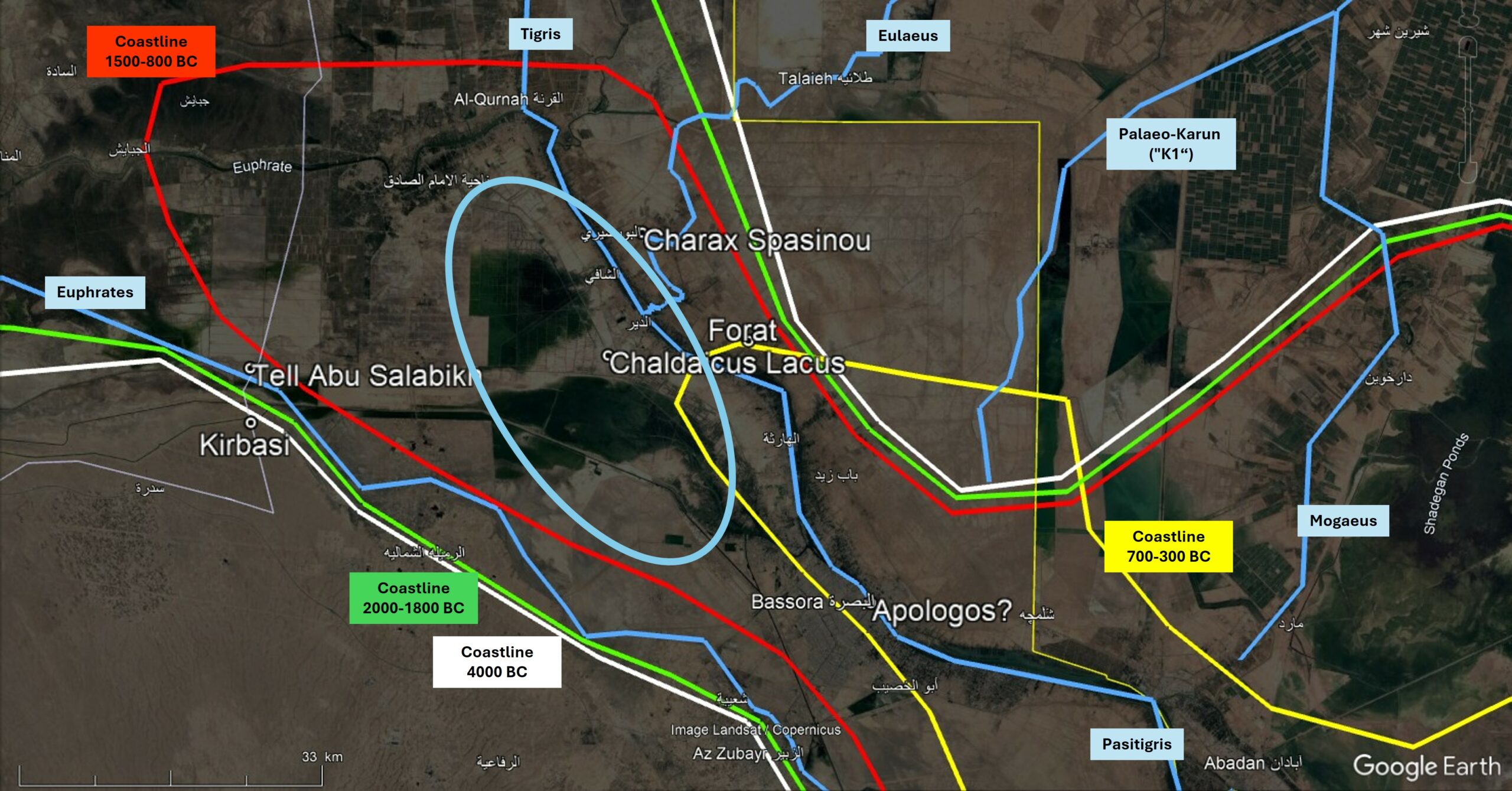
Charax Spasinou is at the outlet of the Eulaeus on the lake.
River Eulaeus (also: Ulai, Ulaya): mentioned by Strabo, Pliny, Arrian and Marcian connecting the city of Susa to the Tigris. Hence, the Tigris and the Eulaeus both flowed into Chaldaicus Lacus, enabling sailing upstream from the sea via the Pasitigris to the lake, and then via the Eulaeus to Susa. The southern part of the Eulaeus is now called Palaeo-Karun “K2”, and its northern part is the modern River Karkheh. In Antiquity, there was a connection known as “Kh1” between the two rivers near present-day Ahwaz (Cole & Gasche, 2007, Walstra et al., 2010, Heyvaert et al., 2012, Heyvaert & Baeteman, 2007). The oldest track of the Karun is called “K1”, and it moved from this old central track first to the north (“K2”) around 300 BCE or later, and then to the south to its present course (“K3-K3b”) around 750-1000 CE (Heyvaert, 2007). As Charax Spasinou was founded by Alexander-the-Great at the outlet of the Eulaeus (“K2”), it must be accepted that the K2 track was operational in 325 BCE and that Nearchus sailed it early 324 BCE on his way to Susa.
The following places may be considered as ports on the Eulaeus:
- Susa (also: Shushan, Seleucia ad Eulaeum) is located between two rivers: the Choaspes (modern River Karkheh) and the Koprates (modern River Dez). This very old city was a regional capital where Alexandre-the-Great met his fleet admiral, Nearchus, when returning from the Indus Valley.
- Aginis is mentioned solely by Arrian during Nearchus’ journey from Chaldaicus Lacus to Susa, placing it 500 stadia (about 90 km) from Susa. It might therefore be located on a tell in the area of the modern Karkheh Deviation Dam (e.g., 31.557°N, 48.493°E).
- Charax Spasinou (also: Spasinu Caras, Charax of Hyspaosines, Alexandria, Antiochia, Maysan on Mesanites Sinus?). Emporium mentioned by Strabo and by the anonymous author of the “Periplous Maris Erythraei”, located at Naisan, Jebel Khayabir, about 18 km SE of el-Qurnah. This city was strategically established in 324 BCE by Alexander-the-Great on Chaldaicus Lacus and the Tigris, at the outlet of the Eulaeus, serving as an emporium where seagoing ships and riverboats could meet for the exchange and transfer of goods (Cole & Gasche, 2007, Walstra et al., 2010, Heyvaert et al., 2012, Moon, 2016).
River Pasitigris: Shatt el-Arab, around 150 km from the supposed outlet of the Chaldaicus Lacus. The following places may be considered as ports on the Pasitigris:
- Forat: mentioned by Pliny, at Maghlub, about 16 km SE of Charax (Cole & Gasche, 2007).
- Apologos (also: Coromane (Marcian)? Koromanis (Ptolemy)?). Possibly located at al-Ubullah? al-Abelah? al-Ashar in modern Bassora, Basra? This port is mentioned solely by the anonymous author of the “Periplous Maris Erythraei” and its location, probably around modern Bassora, is very uncertain (Salles, 2012).
River Mogaeus (also: Mogeus, Mogaios, Mosaios): this river is mentioned only by Marcian, at 700 stadia (ca. 130 km) downstream of Charax. This distance is perhaps somewhat exaggerated as it leads to Bahar not far from the modern sea outlet of the Shatt el-Arab. The mouth of the modern River Karun at Khorramshahr would be a better choice as only at 500 stadia (ca. 90 km) from Charax. In this hypothetical case, the Mogaeus would correspond to the “K3-K3b” track of the Karun (Heyvaert et al., 2013, fig. 3) supposing that the “modern” Karun course was already operational in Marcian’s time (5th c. CE).
River Hedyphon: River Jarrahi, called River Marun, Maroon further upstream. Its hypothetical ancient outlet might have been near Khor Musa (Heyvaert et al., 2013, fig. 3): following the “J2” track starting west of Tell Tendy (30.8548°N, 49.4717°E). Note that the “J1” track might be much older than “J2”, and modern “J3” is too recent. The “J2” choice is very hypothetical and ancient authors do not mention it. This outlet might explain the muddy shallows mentioned by Nearchus, as this river seems to carry much sediment). Note that the “J1” track might be much older than “J2”, and modern “J3” is too recent. The “J2” choice is very hypothetical and ancient authors do not mention it. This outlet might explain the muddy shallows mentioned by Nearchus, as this river seems to carry much sediment.
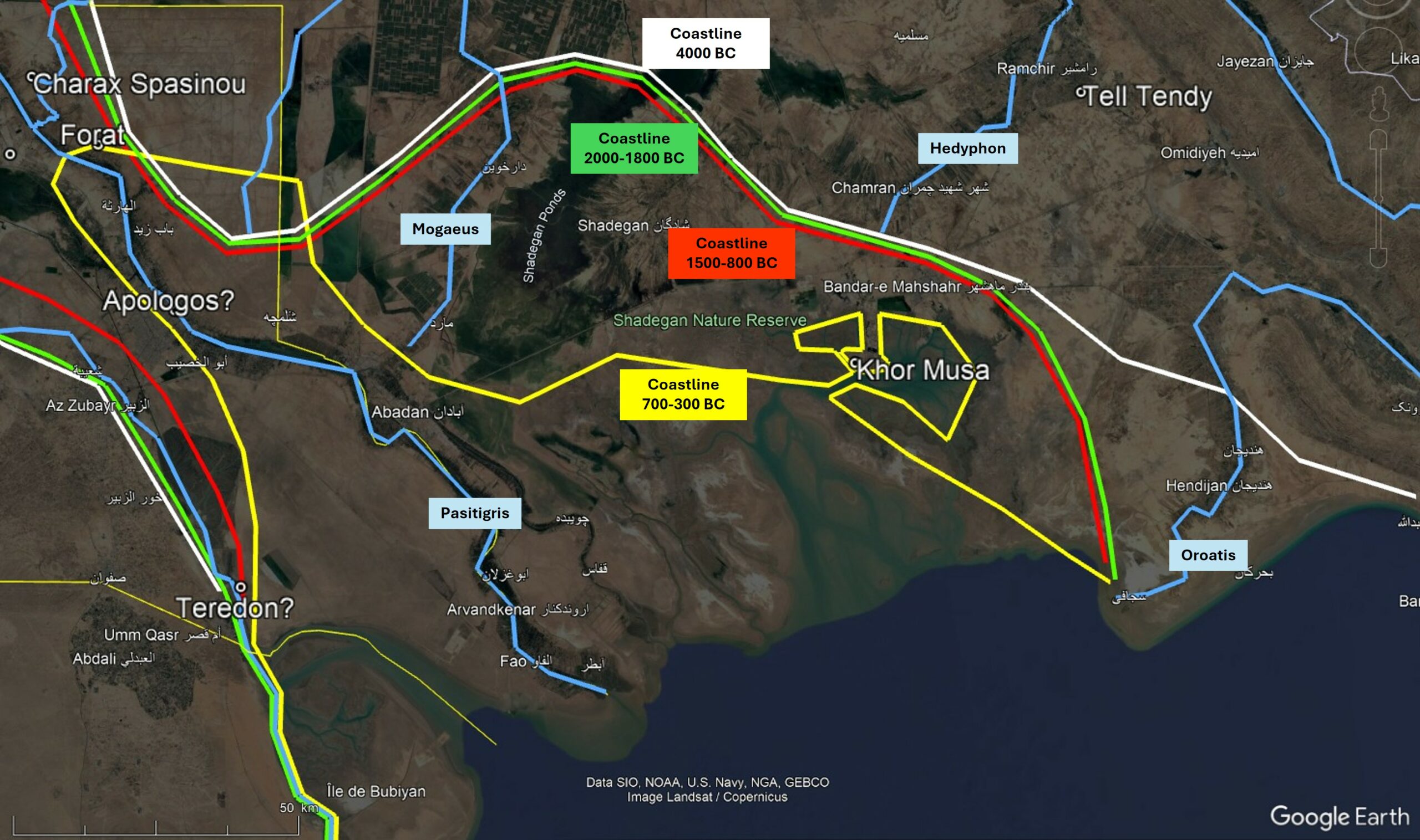
Margastana insula (Arrian) very hypothetically located at Bandar-e Emam Khomeyni, inside Khor Musa.
Kataderbis Lake: very hypothetically located at Khor Musa. Nearchus mentions a lake full of fish where his fleet anchored for the night (Arrian, 8, 41). Its access was rather narrow, as they had to sail in a single line when leaving the next morning. Dangerous muddy shallows were encountered at the lake exit, marked by wooden poles by local sailors.
Margastana insula: this could be Bandar-e Emam Khomeyni, inside Khor Musa (very hypothetically). This island is mentioned by Nearchus (Arrian, 8, 41) and located at the entrance of Kataderbis Lake. Potts (1999) mentions Bandar Mahshahr as unlikely because it is not an island today. It is nevertheless an old 3rd c. CE city. Perhaps nearby Bandar-e Emam Khomeyni is an interesting alternative.
Similarly to the above description of Margastana insula and Kataderbis Lake, Marcian (1, 21) mentions a Taxiana insula, located in front of Sinus Pelodes, (also: lake Palode, Sinus Steloas). Again very hypothetically, it is tempting to consider that Arrian and Marcian talk about the same places.
River Oroatis (also: Arosis, Shirin): River Zohreh, where Nearchus anchored (Arrian, 8, 39; Marcian, 1, 21). This is the river mentioned most easterly in the delta of the Tigris-Euphrates.
The maps above and the kml file provide new insights aimed at solving the complex puzzle of the ancient Tigris-Euphrates Delta. They help understand the historical context of the area inside the changing geographical framework, and how new port-cities were founded as the coastline shifted seaward. However, much work remains to be done…
References
Adams, R. M. (1981). Heartland of Cities: Surveys of Ancient Settlement and Land Use on the Central Floodplain of the Euphrates | Institute for the Study of Ancient Cultures. University of Chicago Press. https://isac.uchicago.edu/sites/default/files/uploads/shared/docs/heartland_of_cities.pdf
Aqrawi, A. (2001). Stratigraphic signatures of climatic change during the Holocene evolution of the Tigris-Euphrates delta, Lower Mesopotamia. Global and Planetary Change, 28, 267–283. https://doi.org/10.1016/S0921-8181(00)00078-3
Blackman, D. (1982) ‘Ancient Harbours in the Mediterranean, Part 1’, International Journal of Nautical Archaeology, 1, pp. 79–104. Available at: https://doi.org/10.1111/j.1095-9270.1982.tb00064.x.
Cole, S. and Gasche, H. (2007) ‘Documentary and Other Archaeological and Environmental Evidence Bearing on the Identification and Location of the Rivers of Lower Khuzestan and the Position of the Head of the Persian Gulf, ca. 1200 BC – 200 AD’, in The Persian Gulf Shorelines and the Karkheh, Karun, and Jarrahi Rivers: A Geo-Archaeological Approach. (First Progress Report), pp. 5–72. Available at: https://www.academia.edu/7531835 (Accessed: 16 June 2025).
Curtis, J., Raheed, Q.H., Clarke, H., Hamdani, A.M.A., Stone, E., Van Ess, M., Collins, P. and Ali, M. (2008) ‘An Assessment of Archaeological Sites in June 2008: An Iraqi-British Project’, Iraq, 70, pp. 215–237.
D’Agostino, F. and Romano, L. (2013) ‘Abu Tbeirah. Preliminary Report of the 2012-2013 Campaigns’, in. 9th International Congress on the Archaeology of the Ancient Near East (ICAANE), Basel (Switzerland). Available at: https://www.academia.edu/25715089 (Accessed: 10 May 2025).
Djabellaoui, M. (2020) ‘L’organisation territoriale de la Babylonie sous les Kassites’, in Atlas historique du Proche-Orient ancien. Available at: https://www.lesbelleslettres.com/livre/9782251451138/atlas-historique-du-proche-orient-ancien (Accessed: 17 May 2025).
Engel, M., & Brückner, H. (2021). Holocene climate variability of Mesopotamia and its impact on the history of civilisation. In Holocene climate and civilization response (Middle East and North Africa, pp. 77–113). Brill. https://doi.org/10.1163/9789004444973_005
Geyer, B., & Sanlaville, P. (1996). Nouvelle contribution à l’étude géomorphologique de la région de Larsa—Oueili (Iraq). In Oueili—Travaux de 1987 et 1989 (pp. 391–408). ADPF, Paris. https://www.researchgate.net/publication/279187093
Geyer, B. and Sauvage, M. (2020) ‘Les variations du tracé de la côte et des fleuves en basse Mésopotamie’, in Atlas historique du Proche-Orient ancien. Available at: https://www.lesbelleslettres.com/livre/9782251451138/atlas-historique-du-proche-orient-ancien (Accessed: 17 May 2025).
Giosan, L. and Goodman, R. (2025) ‘Morphodynamic Foundations of Sumer’, PLOS ONE, 20(8), pp. 1–17. Available at: https://doi.org/10.1371/journal.pone.0329084.
Hansman, J.F. (1978) ‘The Mesopotamian Delta in The First Millennium, BC’, The Geographical Journal, 144(1), pp. 49–61. Available at: https://doi.org/10.2307/634649.
Heyvaert, V.M.A., Verkinderen, P. and Walstra, J. (2013) ‘Geoarchaeological Research in Lower Khuzestan: State of the Art’, in Susa and Elam. Archaeological, Philological, Historical and Geographical Perspectives. Brill, pp. 493–534. Available at: https://doi.org/10.1163/9789004207417_029.
Heyvaert, V.M.A., Walstra, J., Verkinderen, P., Weerts, H.J.T. and Ooghe, B. (2012) ‘The role of human interference on the channel shifting of the Karkheh River in the Lower Khuzestan plain (Mesopotamia, SW Iran)’, Quaternary International, 251, pp. 52–63. Available at: https://doi.org/10.1016/j.quaint.2011.07.018.
Heyvaert, V. M. A., & Baeteman, C. (2007). Holocene sedimentary evolution and palaeocoastlines of the Lower Khuzestan plain (southwest Iran). Marine Geology, 242(1), 83–108. https://doi.org/10.1016/j.margeo.2007.01.008.
Hritz, C., Pournelle, J. and Smith, J. (2013) ‘Revisiting the Sealands: Report of Preliminary Ground Reconnaissance in the Hammar District, Dhi Qar and Basra Governorates, Iraq’, Iraq. The British Institute for the Study of Iraq Journal, 74, pp. 37–49. Available at: https://doi.org/10.1017/S0021088900000243.
Le Doaré, M., Mura, M., & Giraud, J. (2023). Contribution to the mapping of ancient watercourses of the Uruk – Larsa region (Southern Mesopotamia, Iraq) through remote sensing. Journal of Archaeological Science: Reports, 49, 1–11. https://doi.org/10.1016/j.jasrep.2023.104021.
Moon, J. (2016) ‘Charax Spasinou – Alexander’s lost city in Iraq’. Available at: https://www.charaxspasinou.org/ (Accessed: 10 May 2025).
Pawlicki, F. (2016) ‘Preliminary report on the archaeological survey of the joint Kuwaiti–Polish Mission, Failaka Island, 2012’, Polish Archaeology in the Mediterranean, XXIV, pp. 547–559. Available at: https://doi.org/10.5604/01.3001.0010.0093.
Potts, D.T. (1999) ‘The islands of the XIVth Satrapy’, in Oetjen, R., ed. New perspectives in Seleucid history, archaeology and numismatics: Studies in honor of Getzel M. Cohen. Berlin: Beiträge zur Altertumskunde 355., pp. 375–396. Available at: https://www.academia.edu/41642340 (Accessed: 10 May 2025).
Pournelle, J. (2003) ‘Marshland of Cities: Deltaic Landscapes and the Evolution of Early Mesopotamian Civilization’ [PhD Thesis, Univ. South Carolina]. Available at: https://doi.org/10.13140/RG.2.2.34918.11847
Pournelle, J. (2003). The Littoral Foundations of The Uruk State: Using Satellite Photography Toward a New Understanding Of 5th/4th Millenium BCE Landscapes in the Warka Survey Area, Iraq. In Chalcolithic and Early Bronze Age Hydrostrategies (pp. 5–23). https://www.researchgate.net/publication/258858442
Pournelle, J. (2007). From KLM to Corona: A Bird’s Eye View of Cultural Ecology and Early Mesopotamian Urbanization. In Settlement and Society: Ecology, Urbanism, Trace and Technology in Ancient Mesopotamia (pp. 26–62). https://doi.org/10.2307/j.ctvdjrqjp.8
Salles, J.-F. (2012) ‘Le Golfe persique dans le Périple de la mer Erythrée : connaissances fondées et ignorances réelles ?’, TOPOI. Supplément. 11. Autour du Périple de la Mer Érythrée / Ed. M.-Fr. Boussac, J.-Fr. Salles et J.-B. Yon [Preprint]. Available at: https://www.academia.edu/127152276 (Accessed: 17 April 2025).
Sanlaville, P. (1989) ‘Considérations sur l’évolution de la Basse Mésopotamie au cours des derniers millénaires’, Paléorient, 15(2), pp. 5–27. Available at: https://doi.org/10.3406/paleo.1989.4506.
Sauvage, M. (2020) Atlas historique du Proche-Orient ancien. Available at: https://www.lesbelleslettres.com/livre/9782251451138/atlas-historique-du-proche-orient-ancien (Accessed: 17 May 2025).
Schoff, W. and Marcianus of Heraclea (1927) Periplus of the Outer Sea, East and West, and of the Great Islands Therein. Commercial museum.
Sherratt, A. (2004) Environmental Change: The evolution of Mesopotamia, ArchAtlas. Available at: https://www.archatlas.org/journal/asherratt/environmentalchange/ (Accessed: 27 August 2025).
Steinkeller, P. (2001). New Light on the Hydrology and Topography of Southern Babylonia in the Third Millennium. Zeitschrift Für Assyriologie Und Vorderasiatische Archäologie, 91, 22–84. https://doi.org/10.1515/ZAVA.2001.91.1.22
Vallet, R. (2024). Découvertes récentes à Larsa (Iraq). Comptes Rendus de l’Académie Des Inscriptions et Belles-Lettres, 167, 1–23.
Verkinderen, P. (2015) Waterways of Iraq and Iran in the Early Islamic Period: Changing Rivers and Landscapes of the Mesopotamian Plain. London: I.B. Tauris. Available at: https://www.researchgate.net/publication/312353747.
Vincent, W. (1797) Voyage de Néarque, des bouches de l’Indus jusqu’à l’Euphrate, ou Journal de l’expédition de la flotte d’Alexandre , rédigé sur le journal original de Néarque conservé par Arrien, à l’aide des éclaircissements puisés dans les écrits et relations des auteurs, géographes ou voyageurs, tant anciens que modernes, et contenant l’histoire de la première navigation que les Européens aient tentée dans la mer des Indes. Translated by J.B.L.J. Billecocq. Available at: https://gallica.bnf.fr/ark:/12148/bpt6k5657594s (Accessed: 10 May 2025).
Walstra, J., Verkinderen, P. and Heyvaert, V. (2010) ‘Reconstructing landscape evolution in the Lower Khuzestan plain (SW Iran): Integrating imagery, historical and sedimentary archives’, in Developments in Earth Surface Processes, pp. 111–128. Available at: https://doi.org/10.1016/B978-0-444-53446-0.00022-7.
Descriptions provided by some ancient authors
Strabo (15, 3), (early 1st century CE)
(https://penelope.uchicago.edu/Thayer/E/Roman/Texts/Strabo/15C*.html ):
“4 Now Susa is situated in the interior on the Choaspes River at the far end of the bridge, but its territory extends down to the sea; and its seaboard is about three thousand stadia in length [ca. 550 km], extending from boundaries of the Persian seaboard approximately to the outlets of the Tigris. […] Polycleitus says that the Choaspes, the Eulaeus, and also the Tigris meet in a kind of lake, and then empty from that lake into the sea; and that there is an emporium near the lake, since, on account of the cataracts, [dams] purposely constructed, the rivers cannot receive the merchandise that comes in from the sea nor bring down any either, and that all traffic is carried on by land; for the distance to Susa is said to be eight hundred stadia [ca. 150 km]. Others, however, say that the rivers which flow through Susis meet in one stream, that of the Tigris, oppose the intermediate canals of the Euphrates; and that on this account the Tigris, at its outlets, has the name of Pasitigris.
5 Nearchus says that the coast of Persis is covered with shoal-waters and that it ends at the Euphrates River; and that at the mouth of this river there is an inhabited village which receives the merchandise from Arabia; for the seaboard of the Arabians borders next on the mouth of the Euphrates and the Pasitigris, the whole of the intervening space being occupied by a lake, that is, the lake that receives the Tigris; and that on sailing up the Pasitigris one hundred and fifty stadia [ca. 30 km] one comes to the raft-bridge that leads from Persis to Susa, being sixty stadia [ca. 11 km] distant from Susa; and that the Pasitigris is about two thousand stadia [ca. 370 km] distant from the Oroatis; and that the inland voyage on the lake to the mouth of the Tigris is six hundred stadia [ca. 110 km]; and that near the mouth there is an inhabited Susian village, which is five hundred stadia [ca. 90 km] distant from Susa; and that the voyage inland from the mouth of the Euphrates to Babylon, through a very prosperous land, is more than three thousand stadia [ca. 550 km]. Onesicritus says that all the rivers empty into the lake, both the Euphrates and the Tigris; but that the Euphrates, again issuing from the lake, joins with the sea by its own separate mouth.”
Pliny (6, 26 & 31), (late 1st century CE)
(http://attalus.org/translate/pliny_hn6b.html ):
“31. […] Then comes a shallow stretch of water like a marsh which nevertheless is navigable by way of certain channels; the mouth of the Euphrates; a lake formed in the neighbourhood of Charax by the Eulaeus and the Tigris; then by the Tigris they reached Susa. […] when the two streams [of R Tigris] have reunited, the river is called Pasitigris. Afterwards it is joined by the Choaspes from Media, and, as we have said, after flowing between Seleucia and Ctesiphon empties itself into the Chaldaean Lakes [this is confirmed in 6, 26], and broadens them out to a width of 62 miles. Then it flows out of the Lakes in a vast channel and passing on the right-hand side of the town of Charax discharges into the Persian Sea, the mouth of the river being 10 miles wide. The mouths of the two rivers used to be 25 miles apart, or as others record 7 miles, and both were navigable; but a long time ago the Euphrates was dammed by the Orcheni and other neighbouring tribes in order to irrigate their lands, and its water is only discharged into the sea by way of the Tigris.”
Arrian (8, 41-42), (2nd century CE)
(https://sourcebooks.fordham.edu/ancient/arrian-bookVIII-India.asp ):
“39. […] Then when the flood duly returned, they sailed out, and anchored in a river called Oroatis, greatest, according to Nearchus, of all the rivers which on this coast run into the Ocean. […]
41. Then after traversing five hundred stades they anchored in the mouth of a lake, full of fish, called Kataderbis : at the mouth was a small island called Margastana. Thence about daybreak they sailed out and passed the shallows in columns of single ships ; the shallows were marked on either side by poles driven down, just as in the strait between the island Leucas and Acarnania signposts have been set up for navigators so that the ships should not ground on the shallows. However, the shallows round Leucas are sandy and render it easy for those aground to get off ; but here it is mud on both sides of the channel, both deep and tenacious ; once aground there, they could not possibly get off. For the punt-poles sank into the mud and gave them no help, and it proved impossible for the crews to disembark and push the ships off, for they sank up to their breasts in the ooze. Thus then they sailed out with great difficulty and traversed six hundred stades, each crew abiding by its ship ; and then they took thought for supper. During the night, however, they were fortunate in reaching deep sailing water and next day also, up to the evening ; they sailed nine hundred stades, and anchored in the mouth of the Euphrates near a village of Babylonia, called Didotis ; here the merchants gather together frankincense from the neighbouring country and all other sweet-smelling spices which Arabia produces. From the mouth of the Euphrates to Babylon Nearchus says it is a voyage of three thousand three hundred stades.
42. There they heard that Alexander was departing towards Susa. They therefore sailed back, in order to sail up the Pasitigris and meet Alexander. So they sailed back, with the land of Susia on their left, and they went along the lake into which the Tigris runs. It flows from Armenia past the city of Ninus, which once was a great and rich city, and so makes the region between itself and the Euphrates ; that is why it is called ‘Between the Rivers.’ The voyage from the lake up to the river [Eulaeus] itself is six hundred stades, and there is a village of Susia called Aginis ; this village is five hundred stades from Susa. The length of the voyage along Susian territory to the mouth of the Pasitigris is two thousand stades. From there they sailed up the Pasitigris through inhabited and prosperous country. Then they had sailed up about a hundred and fifty stades they moored there, waiting for the scouts whom Nearchus had sent to see where the King was. He himself sacrificed to the Saviour gods, and held an athletic meeting, and the whole naval force made merry. And when news was brought that Alexander was now approaching, they sailed again up the river ; and they moored near the pontoon bridge on which Alexander intended to take his army over to Susa. There the two forces met ; […]”
Marcian (1, 21), (5th century CE) (Schoff, 1927):
“21. From the eastern mouth of the river Tigris to Charax Spasini 80 stadia [ca. 15 km]. Off this coast lies an island called Apphana, which some include in the sailing course of Arabia Felix, counting 35 islands in that course. From Charax Spasini to the mouths of the river Mogaeus 700 stadia [ca. 130 km]. From the river Mogaeus to the bay of Pelode [Coenosus] 400 stadia [ca. 75 km]. On this bay and in the neighbouring district dwell the Elymaei, who are of the region of Susiana. Off the coast of this bay lies the island of Taxiana. From this bay to the mouths of the river Eulaeus 690 stadia [ca. 130 km]. Inland on this river is the city of Susa, the metropolis of Susiana. From the river Eulaeus to the [sandy] shoal 110 [stadia, ca. 20 km]. From the sandy [shoal] to the mouths of the river Oroatis 1450 stadia [ca. 270 km].”