Location: 28.889N 32.681E
This page is based on the work of Pierre Tallet and his team (Tallet, 2015, 2016, 2024).
Location and harbour layout
The purpose of a port located in this region was to collect products from Sinai (turquoise, malachite and copper from Wadi Ameyra, Serabit el-Khadim and Wadi Maghara in the ‘Land of Mafka’ and ‘Land of Turquoise’). The demand for copper for tools used in the construction of the pyramids of King Snefru and King Khufu was very high.
Sailing across the Gulf of Suez between Wadi al-Jarf and al-Markha (Ras Budran), located on the coast of Sinai, 27 nautical miles away, is not easy with often strong beam winds (5-6 Bft). Whether sailing or rowing, the boat drifts significantly and the beam waves (usually less than 1 m) causes it to roll. It probably took a day to make a single trip, and since Wadi al-Jarf is at roughly the same latitude as al-Markha, the outward and return journeys must have posed much the same navigational problems (Heikell, 2015). Anyway, this port was probably in use for less than a century, as it was replaced by King Khafre by the port at Ayn Sokhna which is still operational nowadays.
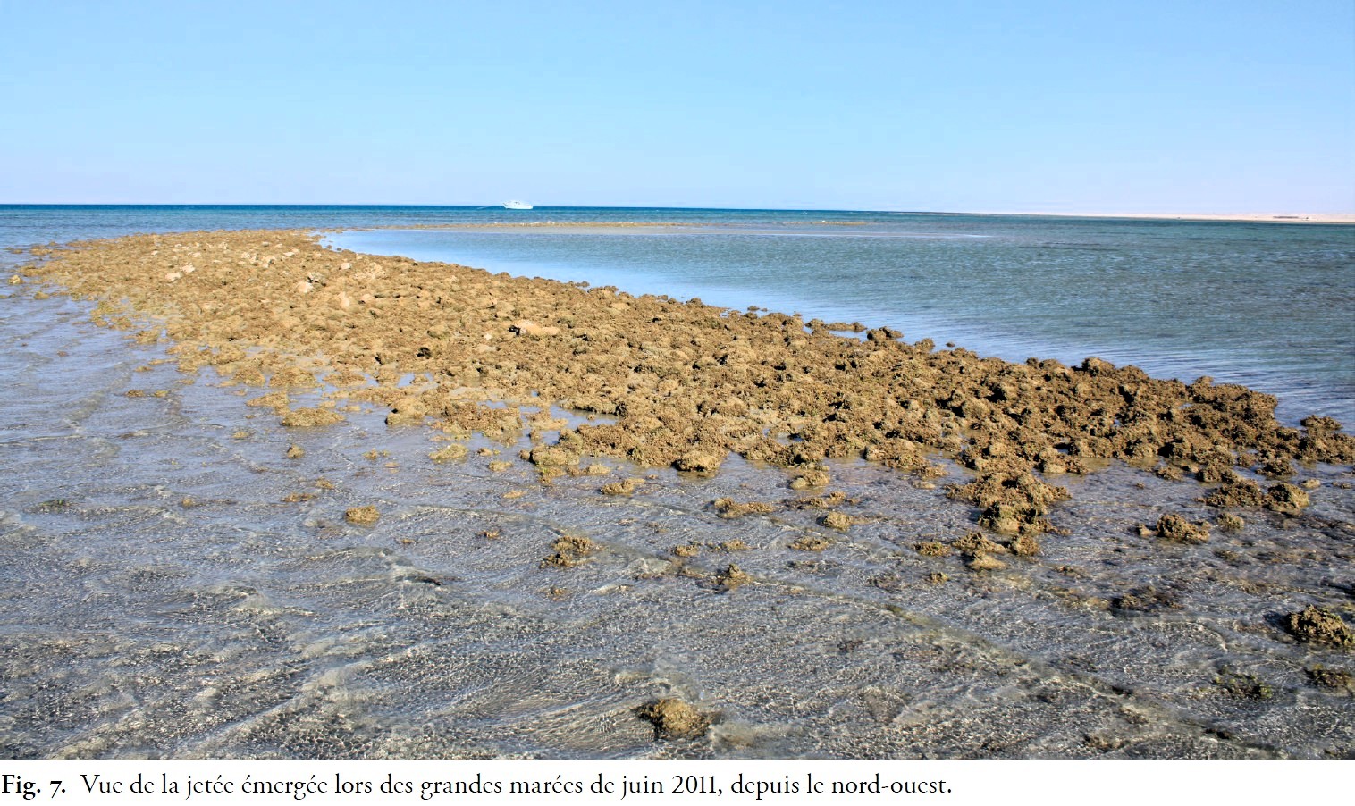
The harbour breakwater is not really in the sea but on the 500 m wide, almost horizontal coral plateau. This area is very well protected from offshore waves (from the N and NW) and the depth there is 1 to 2 m under local Mean Sea Level (MSL). This water depth is sufficient to allow small boats to pass through the breach in the reef, except in the event of strong winds blowing from the land, which can cause the water level to drop by one metre. On the open sea side of the reef, the depth is immediately 5-10 m.
Tidal data indicate a tidal range of approximately 0.5 m (maximum 1 m). When it is Low Water (LW) at the southern entrance of the gulf, it is nearly High Water (HW) at its northern end (e.g., LW at 2:00 a.m. at Ashrafi Island, and HW at 0:28 a.m. at Suez). The HW tidal wave propagates from the entrance of the Gulf of Suez (Ashrafi Island) to its end at Suez, with an increasing tidal range (e.g., HW at 7:56 a.m. at Ashrafi Island, at 10:20 a.m. at el-Tor, at 12:56 p.m. at Zaafrana and Suez; the tidal range increases from 0.6 m to 1.6-1.7 m).
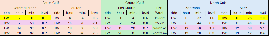
(source: https://www.tidetablechart.com/tides/region/Egypt%20To%20Eritrea )
Wadi al-Jarf is located in the central area of the Gulf of Suez and we assumed that its tidal regime would be close to that of Ras Gharib (but this is open for discussion!). From this data, we deduced a mean LW level at +0.10 m above Chart Datum (CD) and mean HW at +0.60 m CD, yielding a tidal range of 0.5 m. Installing a tidal gauge at Wadi al-Jarf would be most welcome…
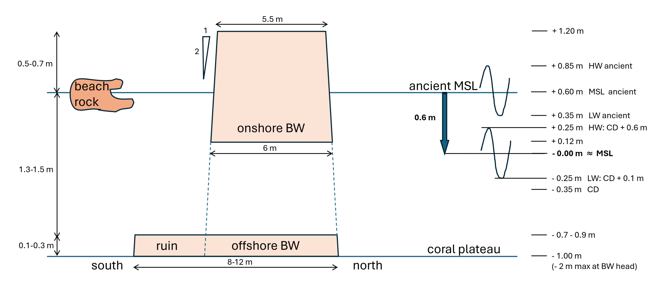
Based on beachrock found on the beach and dated to approximately 4 600 years ago, the former MSL was +0.60 m above the current MSL (probably due to land uplift). The crest of the onshore breakwater (at +1.20 m above current MSL) was therefore 0.35 m above the former mean HW, and can be supposed to have been (almost) always dry.
(beware 1/5 horiz./vertic. distortion!)
The reference level on this sketch was set at an approximate MSL estimated from visual observation of the tides over several months. The coral plateau is around 1.00 m below current MSL, and 1.60 m below ancient MSL. The onshore breakwater is between +0.12 m above current MSL, with its crest around +1.20 m. The offshore breakwater is only 0.1 to 0.3 m high on the coral plateau at 0.7 to 0.9 m below current MSL.
One might imagine that the onshore crest level at +1.20 m was also that of the original offshore breakwater, but the volume of ruins is too small. The offshore crest was therefore probably lower than the onshore crest, perhaps around -0.50 m below current MSL? The offshore breakwater would then have been only 0.5 m high above the coral plateau and would have been covered by 0.8 to 1.3 m of water during ancient tides. It would have allowed the passage of 0.5 m waves generated by the N to NW wind on the coral plateau. A poor shelter! Future excavations around the offshore breakwater will hopefully provide a better understanding of the breakwater’s structure.
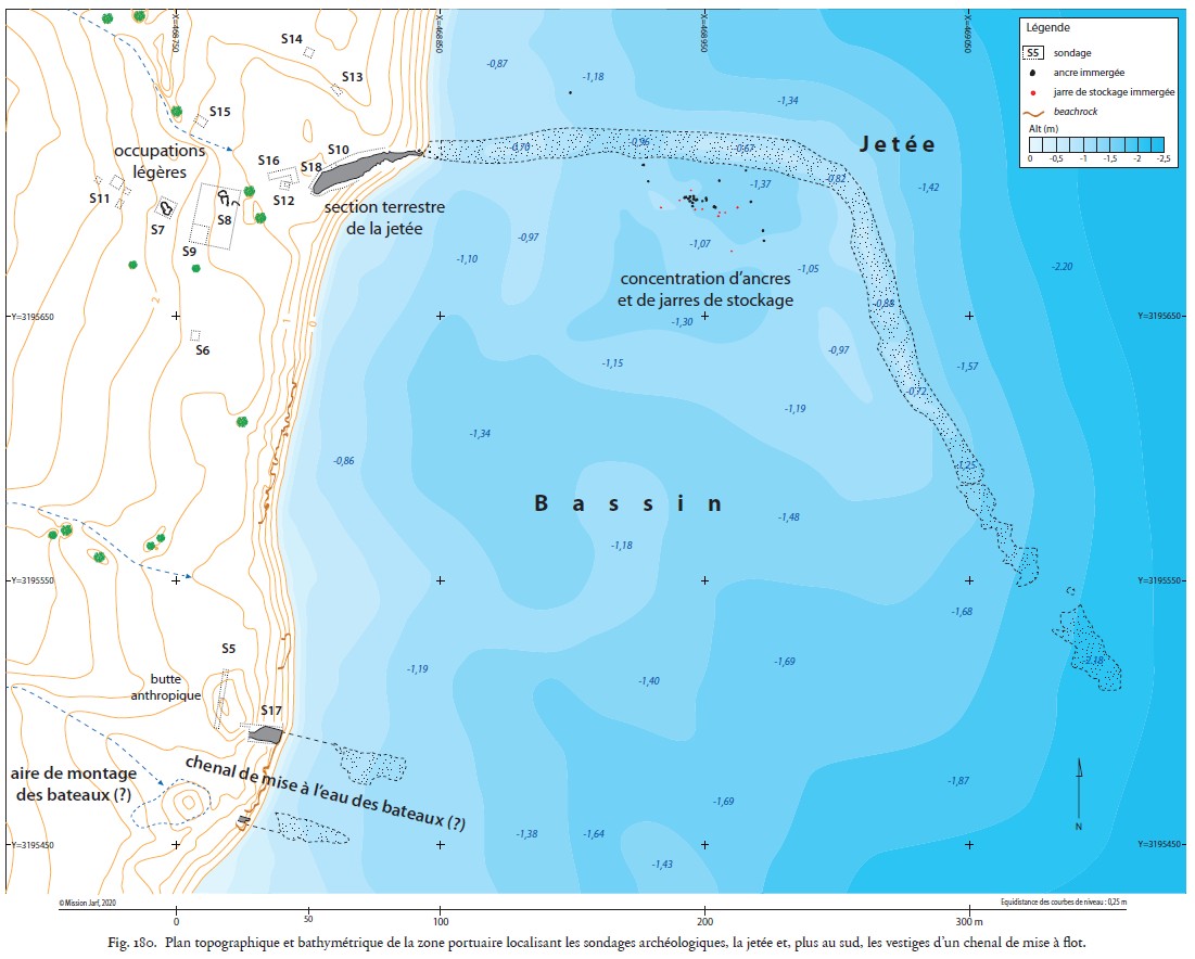
The preferred anchorage seems to have been at the corner of the breakwater, where depths of 1 to 2 m were probably available in ancient times. Abandoned anchors and jars have been found there. But the boats must have beached to unload their cargo, as can still be seen today on the beaches of Senegal. A slipway may have existed 250 m south of the breakwater, and it should be remembered that the boats were dismantled and then reassembled each season in this “intermittent port” (Tallet, 2015).
Breakwater structure
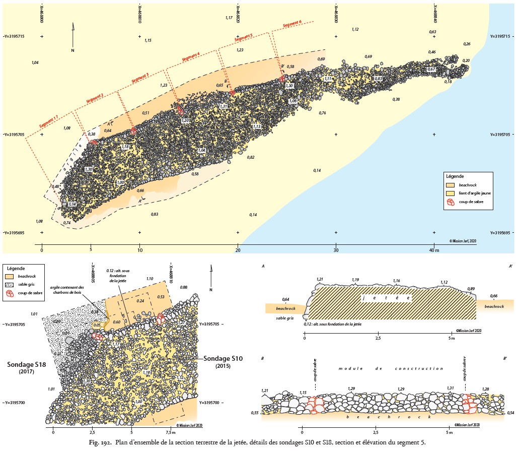
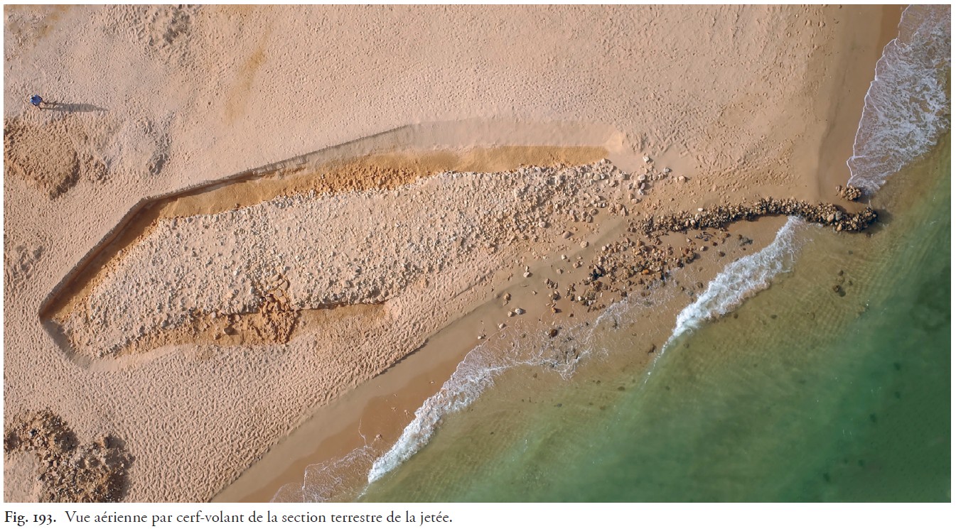
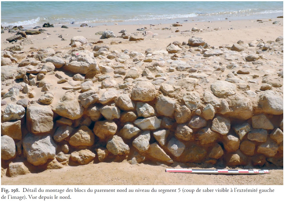
The structure of the offshore breakwater has not been studied by archaeologists. The onshore breakwater appears to be composed of square cells measuring 5.5 to 6 m across. Cobblestones measuring 20-30 cm are used as facing, between which heavily compacted smaller pebbles mixed with clay have been used to fill in. So what is this miracle formula (never seen elsewhere in maritime structures) that has enabled this onshore breakwater to be preserved for 4 600 years?! It should be noted that it has probably spent most of its life out of the water, but further analysis of the clay composition would be welcome.
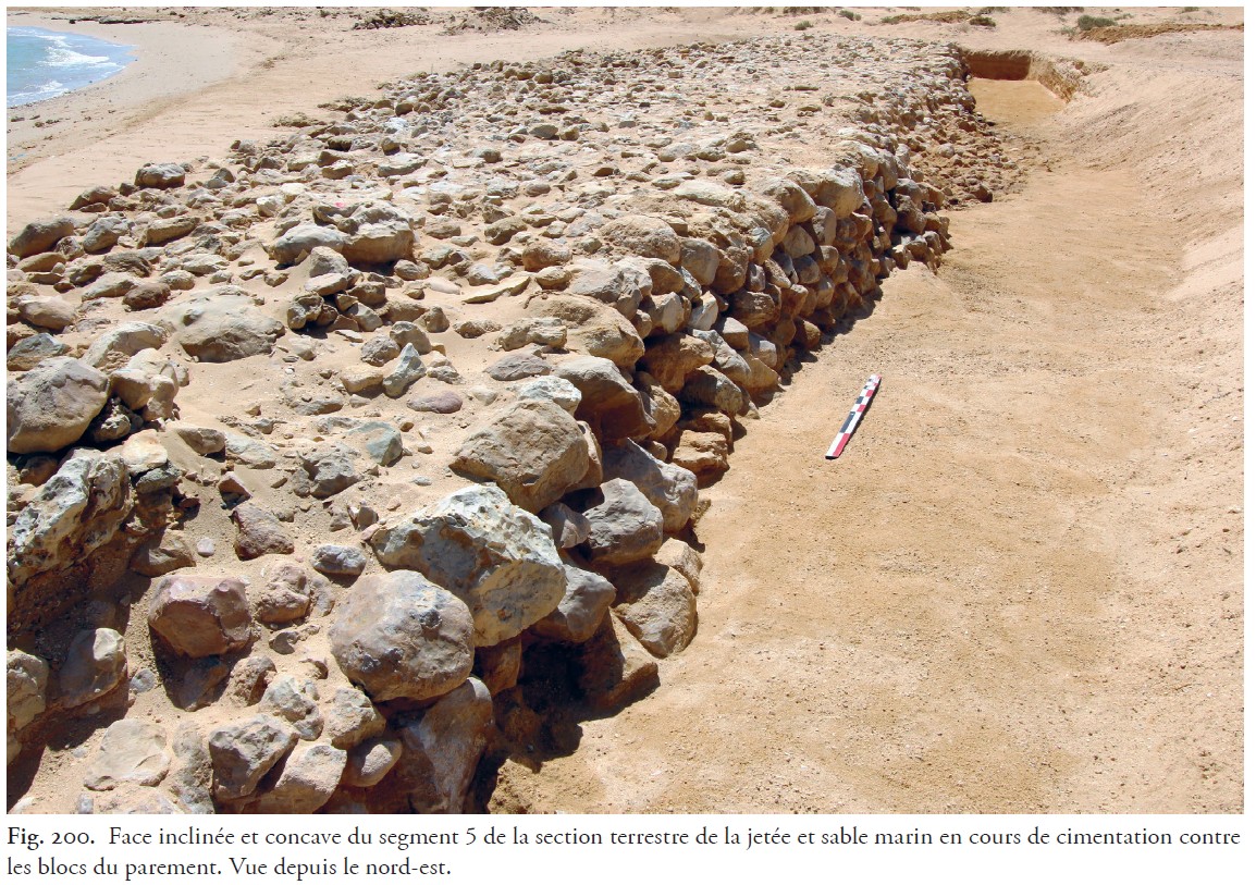
Archaeologists have noted that the northern facing of the onshore jetty is slightly concave, which is quite unusual for maritime structures. The reason for this shape is not yet clear, but it is possible that the ancients used the outside of the hull of one of their boats as a formwork for the construction of the facing, as there is no wood in this region.
The base of the onshore breakwater on “grey sand” is at +0.12 m above current MSL. If MSL was at +0.6 m at the time of construction, it was thus built in 0.5 m of water. Its root was therefore not onshore and left a passage for water from the outset. This is not a problem, as the (small) north-south coastal littoral drift must have quickly filled this water passage.
References
Tallet, P. (2015). Les Ports Intermittents de La Mer Rouge à l’époque pharaonique: Caractéristiques et chronologie. Nehet, 3. https://fr.scribd.com/document/333021695/Les-ports-intermittents-de-la-mer-Rouge-pdf
Tallet, P., & Marouard, G. (2016). The Harbor Facilities of King Khufu on the Red Sea Shore: The Wadi al-Jarf/Tell Ras Budran System. Journal of the American Research Center in Egypt, 52, 135–177. https://doi.org/10.5913/jarce.52.2016.a009
Tallet, P., Marouard, G., & Laisney, D. (2024). Ouadi el-Jarf I: Les installations du littoral (Vols 1 & 2). IFAO. https://www.amazon.fr/Ouadi-el-Jarf-installations-Pierre-Tallet/dp/2724709926
Heikell, R., 2015, “Sailing Ancient Seas”, Taniwha Press, UK, (170 p).